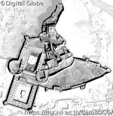
District located at the north of the Citadel, consisting of the governor residence (Governor’s House, governor’s Bath, water well, and the Chāhār-Fasl edifice), defensive buildings (barracks, stable, watch tower), supporting buildings (house of the commander, wind mill). Also consisted of the second gate, Old Gate and Kod (Kot) e kerm gate, and second, third and forth defensive walls. Located on the slope and on top of the cliff
Historical Summary--Core Data Index Metadata
Probably the oldest part of the Citadel is located in this district, which is hidden beneath the newer layers of construction. It might date back to the Sassanid (226-651 AD) period or earlier. The water well and the Kod (kot) e kerm are examples of buildings belonging to this period or earlier (Mehriyar, 1383 Hijri Shamsi (solar)). The buildings in the Governor’s District, on top of the cliff of the Citadel, resemble the city of Firuzabad [built by Ardeshir, founder of the Sassanid dynasty]. The similar elements are as follows (Nourbakhsh 2535 [1353]). • Fire tower, (watch tower of the Citadel) • Four-Vault building (Chartaghi) for holding fire (Atashgah), (Four Season or ChaharFasl building of the Citadel) • Water resource like a spring or a water well that is dug inside a rock as it is believed by ancient Persians that Nahid, or the Water Goddess, was born from stone, (deep water well in the Governor ‘s District of the Citadel)
Copyright (C) 2004-2024 National Institute of Informatics. Copyright is reserved as cited on every data.
کپی رایت (C) 2004-2024 انستیتو ملی انفورماتیک. کپی رایت هر داده بطور جداگانه ذکر شده و محفوظ است. تنها استفاده علمی و پژوهشی از داده ها و مطالب این وبسایت با ذکر مشترک نام دارنده های کپی رایت امکان پذیر است.


