District name from the Konar tree in the middle of the quarter at the north end of the Citadel (Nourbakhsh, 2535)
Historical Summary--Core Data Index Metadata
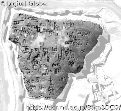
There is ambiguity about the historical date of this quarter. It was built north of the city wall, so it seems it was added to the Citadel. The houses are small and similar to village houses (Gaube 1370 Hijri Shamsi (solar)). [It was Probably built by the inhabitants who remained after the vast destruction in the bigger city and came inside the walls of the present day Citadel]. This event might have happened in 1409 AD by the order of Teimorid governor of the city (Tayyari, 1378 Hijri Shamsi (solar))
Copyright (C) 2004-2024 National Institute of Informatics. Copyright is reserved as cited on every data.
کپی رایت (C) 2004-2024 انستیتو ملی انفورماتیک. کپی رایت هر داده بطور جداگانه ذکر شده و محفوظ است. تنها استفاده علمی و پژوهشی از داده ها و مطالب این وبسایت با ذکر مشترک نام دارنده های کپی رایت امکان پذیر است.


