Silk Road in Rare Books
Narratives on cultural heritage along Silk Road with figures and photographs from rare books.
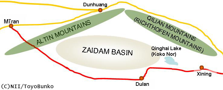
A Lesser Known Route: the Qinghai RouteAnother Route Linking Central Asia and China
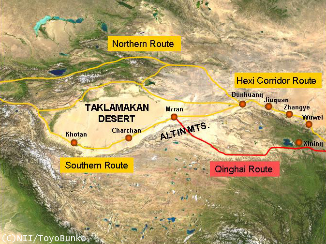
China is connected to Central Asia by a long, narrow corridor-like passage called the Hexi Corridor, which in Chinese means the “west of the Yellow River.” With important oasis cities such as Dunhuang, Jiuquan, Zhangye, and Wuwei located along its path, the corridor has long served as an artery connecting Central Asia and China. In contrast to this much-traveled passageway, the region directly to the south, which is located on the Tibetan Plateau with highlands of more than 3,000 meters above sea level, had long been considered utterly unsuitable as a transport and trade route because of its severe climate and rough terrain. Recent excavations, however, have found that the region had also played an important role in connecting Central Asia and China—functioning as a southern alternative route. Almost completely neglected till now, this alternative route, known as the Qinghai route, has recently been gaining attention.(Map(1)). A new theory suggests that the main Silk Road route running from Central Asia to China divided in two at Mīran: one path following the Hexi Corridor through Dunhuang, and the other more southern route passing through the Qinghai region. This southern Qinghai Route began at Mīran and continued through Altin Tag to the west of the Qilian Mountain Range. It then entered the Zaidam Basin passing Lake Qinghai, continuing on to the valley of HuangShui, which is near modern day Xining. From HuangShui, the route then led on to the Wei Basin to the east or in to the Sichuan Basin to the southeast.
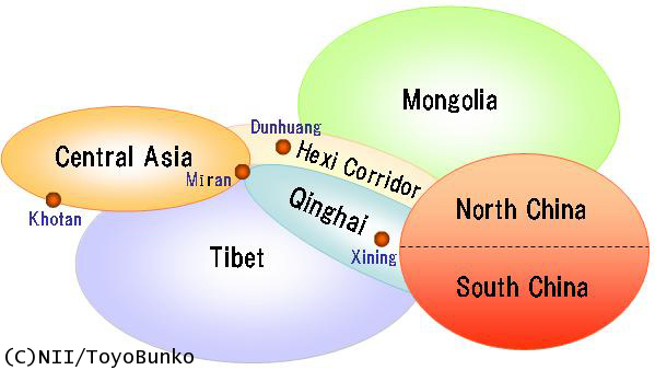
The Qinghai region, at first glance appears to be a very out-of-the-way place surrounded by towering mountains and far from the center of Chinese culture. But considering its geography- with Mongolia to the north, Northern and Southern China to the east, Tibet to the south, and Central Asia to the west- it became an obvious trade route standing as a practical intersection of five routes (The Positional Relationship Between the Qinghai Regions and the Neighboring Areas(2)). In short, the region occupied one of the important areas connecting Central Asian countries to Northern and Southern China, andrecent excavations have gradually been revealing various till now unknown aspects of the Qinghai route. An Unexpectedly Important Route: QinghaiThe Tuyuhun and the Tubo were the Tibetan tribes that dominated the Qinghai region and facilitated trade and transportation between west and the east through the Qinghai route. The Tuyuhun, in particular, actively utilized the trade route. The Tuyuhun were a nomadic tribe that flourished in this area from the fourth to the seventh century, corresponding to the period when China was divided between the Northern and Southern Dynasties. It is said that their origins can be traced back to the Murong clan, a tribe related to the Xianbei from Northeast China. This clan broke away to found the Tuyuhun tribe and came to dominate the native Tibetans in the Qinghai region. The tribe got its name from an ancestor of the royal family, called Murong Tuyuhun. Because of a feud with his siblings, Murong left the tribe, escaping with his family to the west, traveling to the the Yinshan area on the southern Mongolian Plateau. Then at the beginning of the fourth century, when the Eastern Jin Dynasty relocated its government to the south during the Yongjia turmoil, Murong took advantage of this state of political turmoil and entered the Qinghai region. Excerpts from the Travels of Song-Yun, written by the Buddhist monks and travelers Song-Yun and Hui-Sheng, tell us something of the importance of the Qinghai route as a transportation route. In 518, by the order of Empress Dowager Hu, the monk Song-Yun headed for India from the Tang capital of Luoyang with the aim of obtaining Buddhist scriptures. Instead of taking the main route through the Hexi Corridor, Song-Yun took the Qinghai route, which was under the control of the Tuyuhun and traveled along the Qinghai Route to Shan-shan (Loulan), which was located on the southern route of the Silk Road. The fact that such an important person used the Qinghai route suggests that not a few people did in fact utilize this alternative route, which was under the protection of Tuyuhun. The Tuyuhun, it seems, served as the intermediaries in trade the various nations of Central Asia and China along the Qinghai route. One of the Chinese histories, the Book of Zhou, features a story about a provincial governor (Cishi 刺史) of the Northern Zhou who ordered the attack of a royal envoy of the Tuyuhun, on their way back from a visit to the Northern Qi, in Northeast China in 553. The scale of the envoy’s traveling party was so large that it included 240 Iranian merchants and 600 camels, carrying an enormous amount of silk. This record shows that the Tuyuhun generated large profits by acting as the middlemen for Central Asian merchants to China. At the same time, records from the Southern Dynasties tell us that the Tuyuhun also mediated between Central Asian countries and Southern China. According to a chapter from the Book of Liang, people of the Tuyuhun tribe, known as “Henan” in the Book of Liang, worked as interpreters between the Central Asian nomadic Hephthalite tribe (also known as the “White Huns”) and China. The Southern Qi History also tells us that when people from Loulan traveled to the Sichuan Basin, they took the Qinghai route, which was controlled by the Tuyuhun. By serving as mediators in the trade between the countries ofCentral Asia and Northern and Southern China, the Tuyuhun must have made tremendousprofits. In additions, they were able to extend their power as far as far north as Mīran and Charchan along the Silk Road’s Southern Route. By controlling Mīran, which stood at the junction of the Hexi Corridor and the Qinghai Route, the Tuyuhun were able to make sure that more goods would be routed along the Qinghai route, instead of the Hexi Corridor, providing for themselves even greater advantage in the east-west trade. Watching the Tuyuhun growing rich, dynasties such as the Northern Wei (Emperor Taiwu), Sui (Emperor Yang of Sui), Tang (Emperor Taizong) attempted in turn to subdue their power. In 445, when the Northern Wei subjugated the Tuyuhun, the chieftain of the time, Muliyan, left the area and invaded Khotan, killing the king and many people there, before continuing on westward to Kashmir.
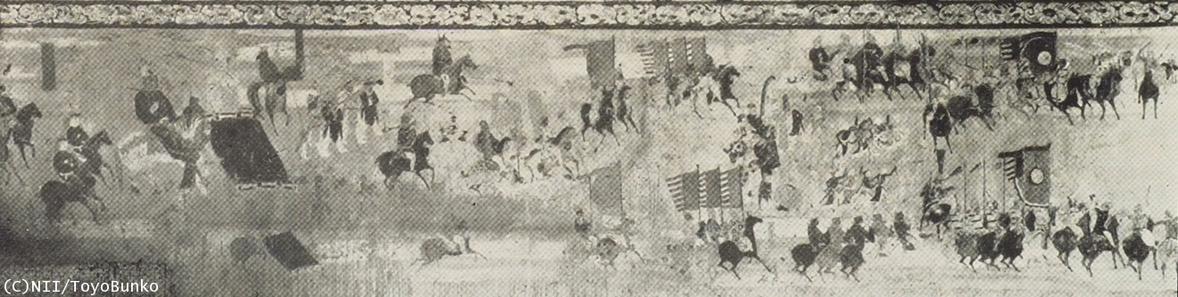
Later, another Tibetan tribe, the Tubo, overthrew the Tuyuhun and came to control the Tibetan Plateau from the seventh to the mid-ninth century. In 663, the Tubo occupied the Qinghai (Koko Nor) region, and after defeating the Tuyuhun, they then invaded the territory of Chinese under the Tang Dynasty. When the An Shi Rebellion (755-763) weakened the Tang court, the Tubo poised a grave threat to the Tang capital of Chang’an, and seized the Hexi Corridor in order to strengthen their base. Around that time, the Mogao Caves in Dunhuang were also under the control of the Tubo. For a certain period, the Tubo controlled the traffic routes between the Tarim Basin and the Hexi Corridor, wielding enormous power over the area. But its territory was gradually reoccupied by the Tang, which had formed a coalition with the Uighurs. In 855, when the Provincial Governor of Dunhuang, Zhang Yichao, formally submitted to the Tang, the Tubo had at last lost its control over the region (Painting of Zhang Yichao’s Troops on the South Wall in Cave 156(3)). After the Tang dynasty, the Qinghai route has rarely been mentioned in historical records. Mīran: Standing on the Southern Route of the Silk RoadFor the Tuyuhun and the Tubo, the town of Mīran was an important and strategic gateway between the Southern Route of the Silk Road and the Qinghai Route. Meanwhile, due to its location on the Southern Route of the Silk Road, Miran was also a city in which culture from the West made its existence known . And representing this dual heritage, two completely different kinds of ruins are to be found in Miran, dating from different periods. The first are Buddhist shrines dating back to before the end of the third century.
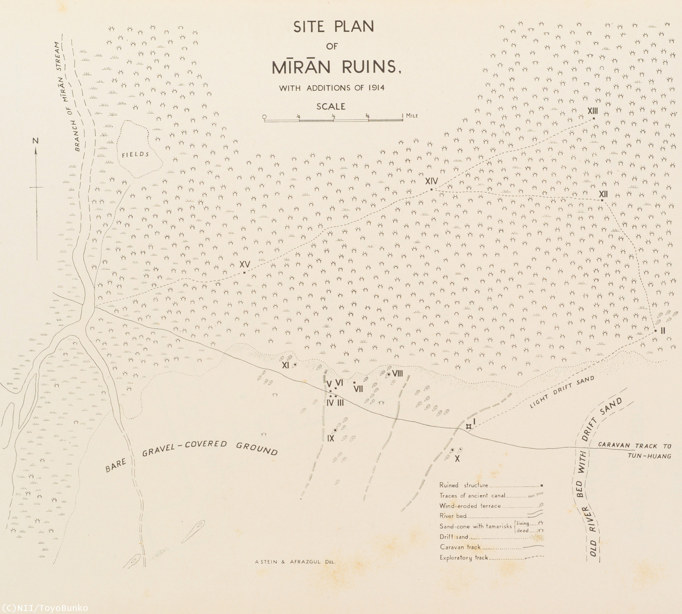
Marc Aurel Stein, a British archeologist, discovered and surveyed the remains of Buddhist shrines in Mīran in December 1906 and in January 1907 (Photos of M.III-VI(4), Site Plan of Mīran Ruins(5)). At Miran, he found murals and stucco images created in the Greek and Roman style. As Stein put it, the designs and colors were more obviously Greek and Roman-influenced than any other paintings he had encountered north or south of the Kunlun Mountains (On Ancient Central-Asian Tracks). The art seemed to have been strongly influenced by western cultures.
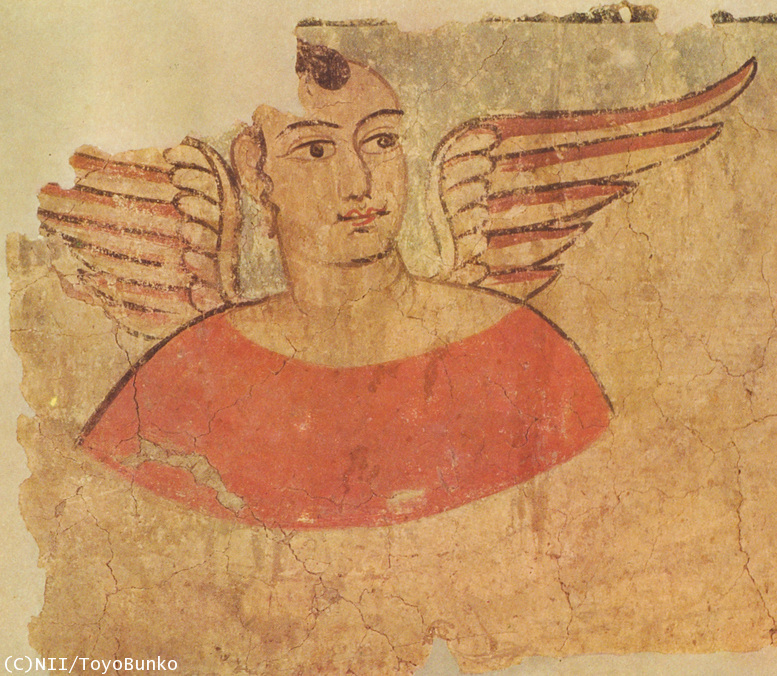
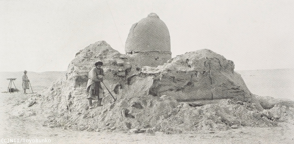
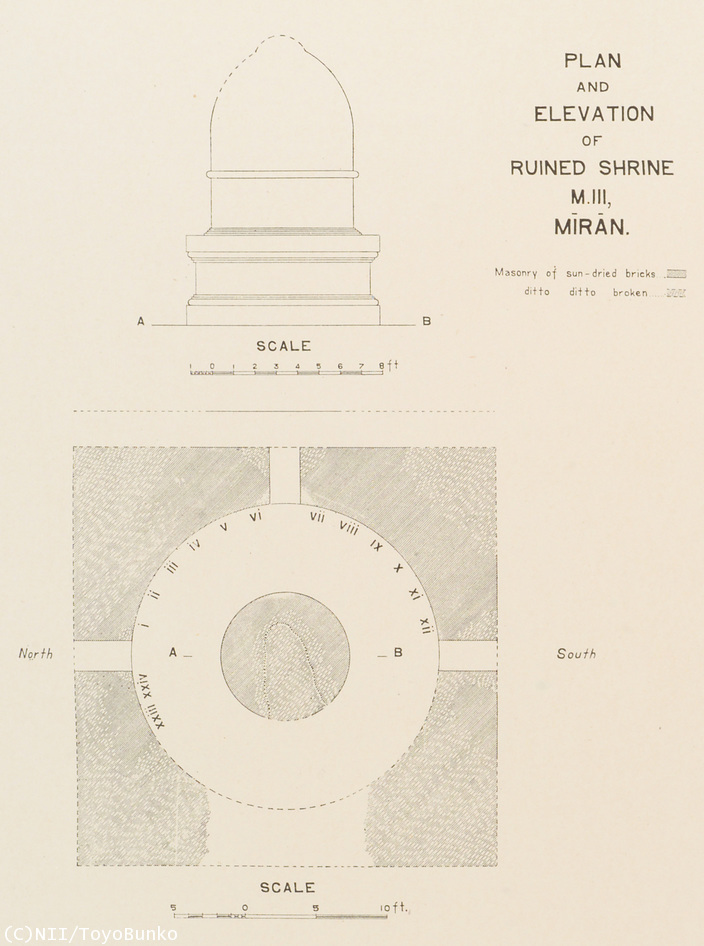
Among the most surprising art works discovered by Stein was a painting of a Winged Angel(6), which was discovered in ruined shrine M.III, Mīran (Photo(7), Plan and Elevation of Ruined Shrine M.III(8)). The corridors on the foundations of the stupa were stacked with rubble fallen from the vaulted ceiling or the upper parts of the surrounding walls. Among the debris, a part of the wall painting on the stucco suddenly came into sight. When I saw the angel elaborately painted on the dado 1.2 meters above the floor, I was first caught off guard and stood there motionless. How could I imagine that I would come across cherubim painted in Greek and Roman style at the desolate shore of Lake Lop Nor in the interior of Central Asia? (On Ancient Central-Asian Tracks)
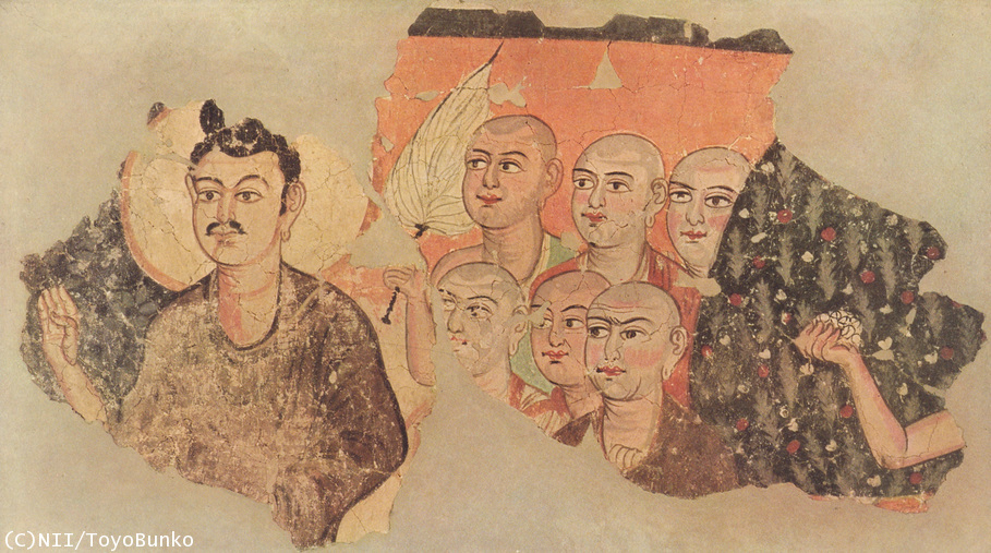
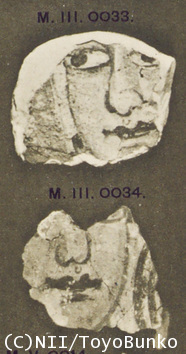
In the same M.III shrine, Stein also discovered other wall paintings in vibrant colors, where the Buddhist figures were with cheerful expressions; with widely-opened eyes and wavy lips (Painting of Buddha and the Disciples(9), Fragments of Murals(10)).
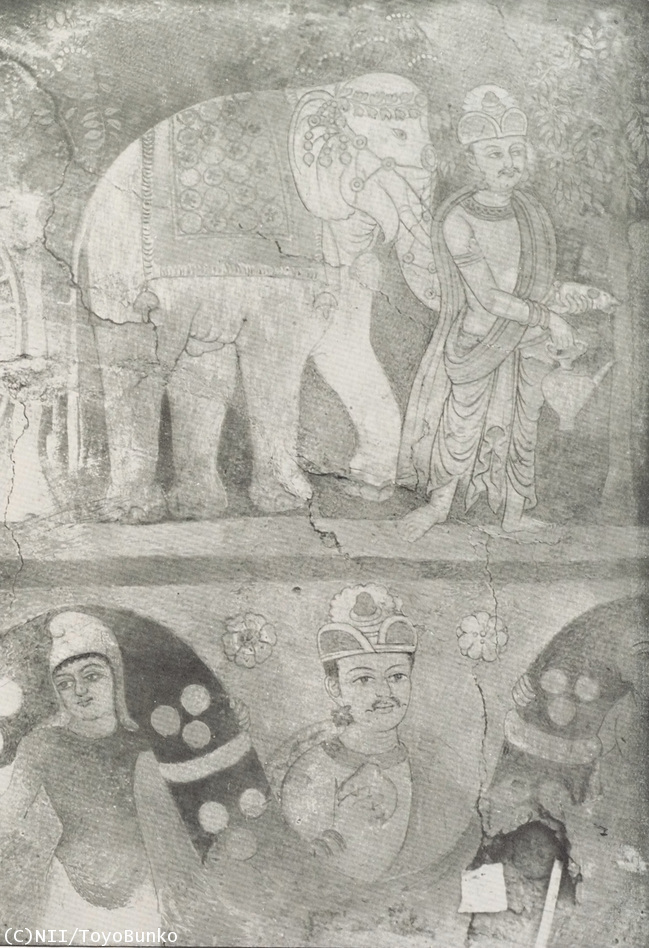
Similar to the M.III shrine, the fifth shrine had a square-shaped structure with a stupa in the s center. There, Stein found a 5.5-meter-long wall painting which portrayed one of the stories of the Buddha’s previous lives the story of Vishvantara (Vessantara or Sudhana) Jataka (Painting of Vishvantara Offering a White Elephant(11)). But the mural was too vulnerable to remove, and the painting was recorded only in photographs.
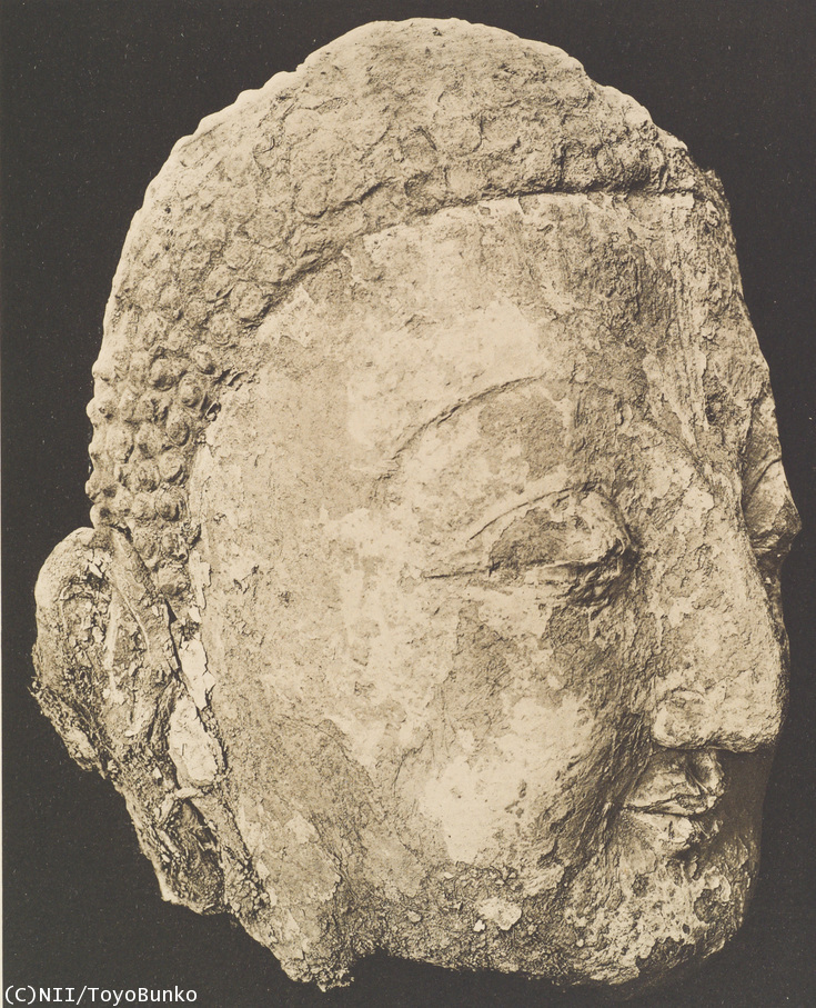
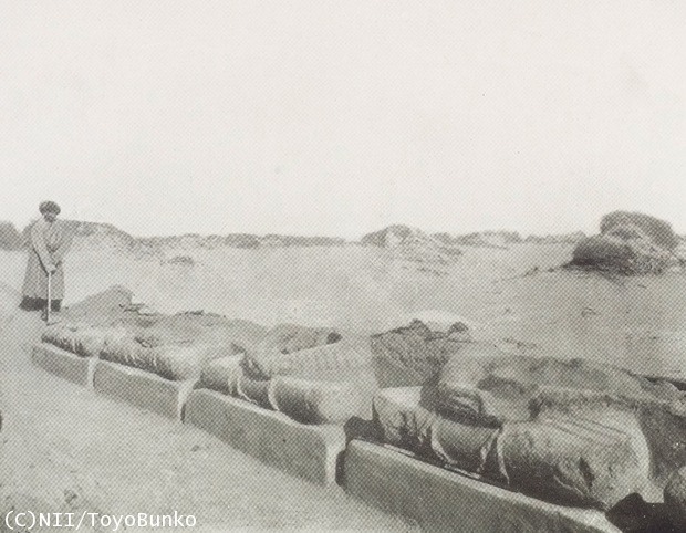
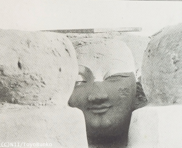
At M.II shrine, Stein found several stucco images of Buddhas (Colossal Head of Buddha in Stucco(12), larger‐than‐life, laid in rows (Remains of Colossal Stucco Images of Seated Buddhas(13), Heads of Buddha Dropped Between the Laps(14)). Inscriptions in Kharoshthi script written on the paintings showed that these shrines had been abandoned at the end of the third century. Other documents in Kharoshthi were also found at Loulan, Niya, and Endere, suggesting the way Indian culture influenced these areas. Mīran was a city where both western cultures, which came through the southern route, and Indian culture thrived. More Facts on Qinghai Route are being revealed
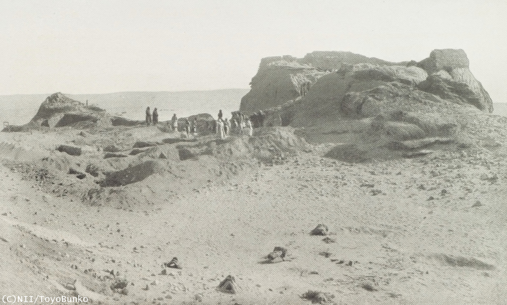
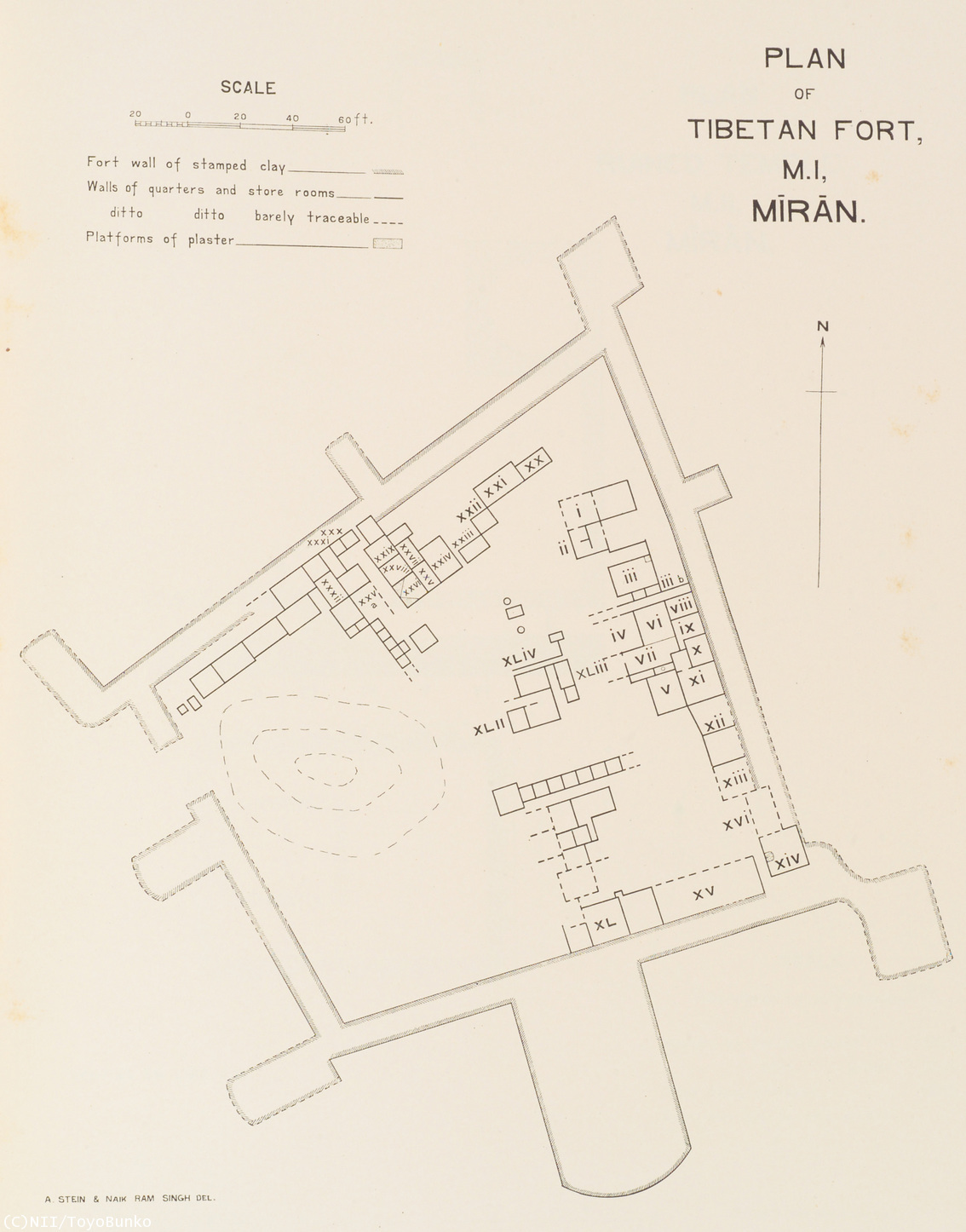
Influenced by western cultures, Buddhism thrived in Mīran. But the city seems to have been deserted around the end of the third century. Experts found other ruins built several centuries later there. These ruins reflected another side of Miran’s history; specifically its role standing as the gateway between the Silk Road’s Southern Route and thethe Qinghai Route. At Miran, Stein discovered Tibetan forts (Photo(15), Plan(16)). According to the Tibetan Documents(17) gathered from the layers of rubbish, they were built by the Tubo between the eighth and the ninth century. This shows that the Tubo used Mīran as a base to rule Central Asia.
From Stein’s work, it became known that the Tubo wielded power and influence over Mīran. Despite many insights into the history of Miran, still little was known about the Qinghai Route. However, recent excavations have unearthed more and more ruins indicating a vibrant east-west trade that existed along the route. In particular, excavations of the ancient Tubo tombs at Dulan (Map of Qinghai Region(18)), to the south of the Qaidam Basin, have been attracting much attention since the 1980s. At Dulan, more than 1,000 Tubo tombs have been found, which shows that this area served as an important relay point on the Qinghai route. The tomb of Xuewei M1 is a large-size tomb with flat-topped quadrangular mound similar to other royal tombs of the Tubo. It is situated facing the south, is 33 meters high, 55 meters across, and 37 meters long. Inside the tomb, more than 700 horses, cows, and sheep were also interred. Researchers have unearthed leather shoes, Tibetan wooden manuscripts, painted or wooden-carved animals, grains, and a large number of silk products. The tomb is also surrounded by dozens of small accompanied tombs. Around this area, gold coins of the Eastern Roman Empire, silver coins of the Persian Sassanian Empire, and over 350 silk products were found as well. Many of these silks have peal roundel designs which originated in the Sassanian Empire. What role did the Qinghai Route play during Silk Road times? Almost nothing was known about the route historically. But as the excavations progress, more and more facts have been unveiled. To Learn More
English Edition :
2007-11-22
English Revised Edition :
2010-04-14
Japanese Edition :
2005-09-12
Author : Makiko Onishi, Asanobu Kitamoto
Translator : Yasuhiro Itami ; English adaptation by Leanne Ogasawara
|
Table of Content
High Resolution ImagesIndexRelated SitesNotice
|

All Rights Reserved.