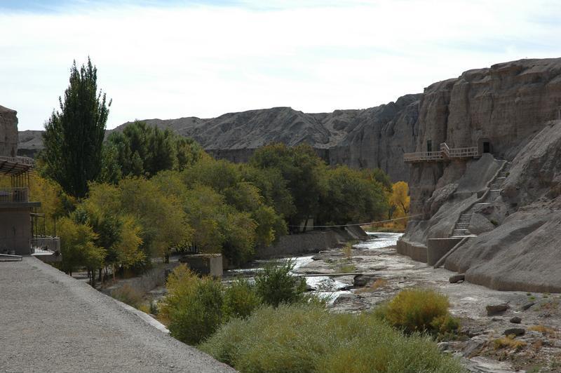
楡林窟と呼ばれるゆえんは、石窟の間を流れる踏実河(またの名を楡林河という)に大きな楡(にれ)の木が生い茂っているからである。 / It is called the Yulin Grottoes,because the Tashi River(also called the Yulin River) lined with the big elm trees, passes through the grottoes.
Card Information
Class
Image Card
Identifier (dcterms:identifier)
http://dsr.nii.ac.jp/photograph/iiif/anxi0006.tif/full/full/0/default.jpg
Spatial Coverage (dcterms:spatial)
楡林窟
Place Card
Is Part Of (dcterms:isPartOf)
http://dsr.nii.ac.jp/photograph/manifest/anxi0006
number (bibo:number)
http://dsr.nii.ac.jp/photograph/iiif/canvas/anxi0006
Source (dcterms:source)
Image
Map
- Stein Place Name - Innermost Asia / Kara-Khoja
- Not Collated
- Hedin Place Name - Central Asia Atlas
- Collated
- German Expeditions Place Name - Idikutschari
- Not Collated (with Image Cards)
- Huang Wenbi Place Name - Archaeological Report in Turfan / Archaeological Report in Tarim Basin
- Collated (with Image Cards)
- DSR Place Name - Silk Road in Photographs
- Ruin Card
Linked Cards
Filter by property
| Title | Alternate label | Class |
|---|---|---|
| Canvas Indexer search result | Curation Card |
Graph of Related Cards
Ruin Card
Image Card
Image Matching Card
Place Card
Place Matching Card
Reference Card
Curation Card