National Institute of Informatics - Digital Silk Road Project
| |||||||||
|
| Scientific Results of a Journey in Central Asia, 1899-1902 : vol.1 |
 |
| Kijik-tele-tschöl, Sept. 29. | |
| TRANSVERSE SECTION OF SHARP BENDS, SEPT. 30TH. |
THE JARKENT-DARJA FROM LAJLIK TO KURUK-ASTI. 27
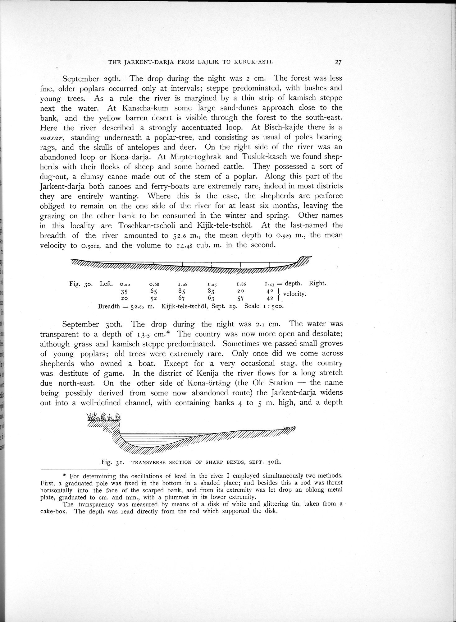
September 29th. The drop during the night was 2 cm. The forest was less fine, older poplars occurred only at intervals; steppe predominated, with bushes and young trees. As a rule the river is margined by a thin strip of kamisch steppe next the water. At Kanscha-kum some large sand-dunes approach close to the bank, and the yellow barren desert is visible through the forest to the south-east. Here the river described a strongly accentuated loop. At Bisch-kajde there is a rasar, standing underneath a poplar-tree, and consisting as usual of poles bearing rags, and the skulls of antelopes and deer. On the right side of the river was an abandoned loop or Kona-darja. At Mupte-toghrak and Tusluk-kasch we found shepherds with their flocks of sheep and some horned cattle. They possessed a sort of dug-out, a clumsy canoe made out of the stem of a poplar. Along this part of the Jarkent-darja both canoes and ferry-boats are extremely rare, indeed in most districts they are entirely wanting. Where this is the case, the shepherds are perforce obliged to remain on the one side of the river for at least six months, leaving the grazing on the other bank to be consumed in the winter and spring. Other names in this locality are Toschkan-tscholi and Kijik-tele-tschöl. At the last-named the breadth of the river amounted to 5 2.6 m., the mean depth to 0.929 m., the mean velocity to 0.5012, and the volume to 24.48 cub. m. in the second.
Fig. 3o. Left. 0.20 0.68 I .o8 1.25 1.86 I.43 = depth. Right.
35 65 85 83 2O 42 I velocity.
20 52 67 63 57 42
Breadth = 52.60 m. Kijik-tele-tschöl, Sept. 29. Scale 1 : boo.
September 3oth. The drop during the night was 2.1 cm. The water was transparent to a depth of I3.5 cm.* The country was now more open and desolate; although grass and kamisch-steppe predominated. Sometimes we passed small groves of young poplars; old trees were extremely rare. Only once did we come across shepherds who owned a boat. Except for a very occasional stag, the country was destitute of game. In the district of Kenija the river flows for a long stretch due north-east. On the other side of Kona-örtäng (the Old Station — the name being possibly derived from some now abandoned route) the Jarkent-darja widens out into a well-defined channel, with containing banks 4 to 5 m. high, and a depth
Fig. 31. TRANSVERSE SECTION OF SHARP BENDS, SEPT. 30th.
* For determining the oscillations of level in the river I employed simultaneously two methods. First, a graduated pole was fixed in the bottom in a shaded place; and besides this a rod was thrust horizontally into the face of the scarped bank, and from its extremity was let drop an oblong metal plate, graduated to cm. and mm., with a plummet in its lower extremity.
The transparency was measured by means of a disk of white and glittering tin, taken from a cake-box. The depth was read directly from the rod which supported the disk.
|
Copyright (C) 2003-2019 National Institute of Informatics and The Toyo Bunko. All Rights Reserved.