National Institute of Informatics - Digital Silk Road Project
| |||||||||
|
| Scientific Results of a Journey in Central Asia, 1899-1902 : vol.1 |
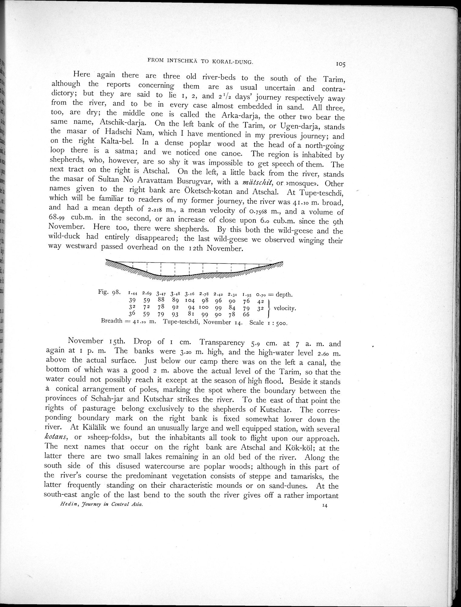 |
| Tupe-teschdi, November 14. |
FROM INTSCIiKÄ TO KORAL-DUNG. 105
Here again there are three old river-beds to the south of the Tarim, although the reports concerning them are as usual uncertain and contradictory; but they are said to lie 1, 2, and 2 '/2 days' journey respectively away from the river, and to be in every case almost embedded in sand. All three, too, are dry; the middle one is called the Arka-darja, the other two bear the same name, Atschik-darja. On the left bank of the Tarim, or Ugen-darja, stands the masar of Hadschi Nam, which I have mentioned in my previous journey; and on the right Kalta-bel. In a dense poplar wood at the head of a north-going loop there is a satma; and we noticed one canoe. The region is inhabited by shepherds, who, however, are so shy it was impossible to get speech of them. The next tract on the right is Atschal. On the left, a little back from the river, stands the masar of Sultan No Aravattam Busrugvar, with a mätschit, or »mosque». Other names given to the right bank are Öketsch-kotan and Atschal. At Tupe-teschdi, which will be familiar to readers of my former journey, the river was 41.10 m. broad, and had a mean depth of 2.218 m., a mean velocity of 0.7568 m., and a volume of 68.99 cub.m. in the second, or an increase of close upon 6.0 cub.m. since the 9th November. Here too, there were shepherds. By this both the wild-geese and the wild-duck had entirely disappeared; the last wild-geese we observed winging their way westward passed overhead on the I2th November.
Fig. 98. I.44 2.69 3.47 3.48 3.16 2.78 2.42 2.31 1.95 0.70 = depth.
39 59 88 89 104 98 96 90 76 42
32 72 78 92 94 100 99 84 79 32 velocity.
36 59 79 93 81 99 90 78 66 J
Breadth = 41.10 m. Tupe-teschdi, November 14. Scale 1 : 500.
November 15th. Drop of 1 cm. Transparency 5.9 cm. at 7 a. m. and again at 1 p. m. The banks were 3.20 m. high, and the high-water level 2.60 m. above the actual surface. Just below our camp there was on the left a canal, the bottom of which was a good 2 m. above the actual level of the Tarim, so that the water could not possibly reach it except at the season of high flood. Beside it stands a conical arrangement of poles, marking the spot where the boundary between the provinces of Schah-jar and Kutschar strikes the river. To the east of that point the rights of pasturage belong exclusively to the shepherds of Kutschar. The corresponding boundary mark on the right bank is fixed somewhat lower down the river. At Kälälik we found an unusually large and well equipped station, with several kotans, or »sheep-folds», but the inhabitants all took to flight upon our approach. The next names that occur on the right bank are Atschal and Kök-köl; at the latter there are two small lakes remaining in an old bed of the river. Along the south side of this disused watercourse are poplar woods; although in this part of the river's course the predominant vegetation consists of steppe and tamarisks, the latter frequently standing on their characteristic mounds or on sand-dunes. At the south-east angle of the last bend to the south the river gives off a rather important
Hedin, Journey in Central Asia. 14
|
Copyright (C) 2003-2019 National Institute of Informatics and The Toyo Bunko. All Rights Reserved.