National Institute of Informatics - Digital Silk Road Project
| |||||||||
|
| Scientific Results of a Journey in Central Asia, 1899-1902 : vol.1 |
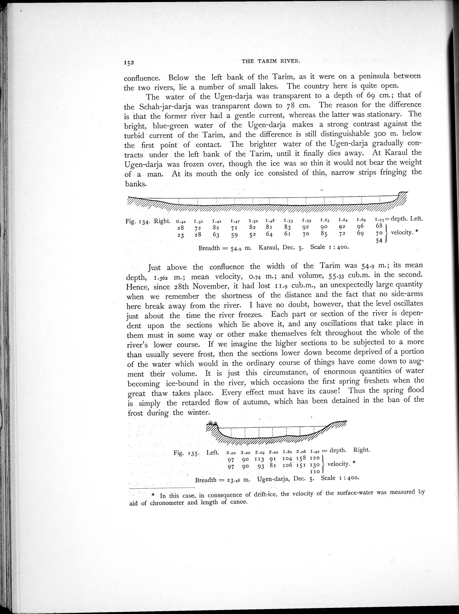 |
| Karaul, Dec. 5. | |
| Ugen-darja, Dec. 5. |
152 THE TARIM RIVER.
confluence. Below the left bank of the Tarim, as it were on a peninsula between the two rivers, lie a number of small lakes. The country here is quite open.
The water of the Ugen-darja was transparent to a depth of 69 cm.; that of the Schah-jar-darja was transparent down to 78 cm. The reason for the difference is that the former river had a gentle current, whereas the latter was stationary. The bright, blue-green water of the Ugeh-darja makes a strong contrast against the turbid current of the Tarim, and the difference is still distinguishable 30o m. below the first point of contact. The brighter water of the Ugen-darja gradually contracts under the left bank of the Tarim, until it finally dies away. At Karaul the Ugen-darja was frozen over, though the ice was so thin it would not bear the weight of a man. At its mouth the only ice consisted of thin, narrow strips fringing the banks.
Fig. 134. Right. 0.42 I.31 I.42 I.47 I.52 1.48 I.53 I.59 I.63 I.64 I.69 I.73= depth. Left.
28 72 82 71 82 81 83 92 90 92 96 68 I
23 28 63 59 52 64 61 7o 85 72 69 7o velocity.*
541
Breadth = 54.9 m. Karaul, Dec. 5. Scale I : 400.
Just above the confluence the width of the Tarim was 54.9 m. ; its mean depth, 1.362 m.; mean velocity, 0.74 m.; and volume, 55.33 cub.m. in the second. Hence, since 28th November, it had lost 11.9 cub.m., an unexpectedly large quantity when we remember the shortness of the distance and the fact that no side-arms here break away from the river. I have no doubt, however, that the level oscillates just about the time the river freezes. Each part or section of the river is dependent upon the sections which lie above it, and any oscillations that take place in them must in some way or other make themselves felt throughout the whole of the river's lower course. If we imagine the higher sections to be subjected to a more than usually severe frost, then the sections lower down become deprived of a portion of the water which would in the ordinary course of things have come down to augment their volume. It is just this circumstance, of enormous quantities of water becoming ice-bound in the river, which occasions the first spring freshets when the great thaw takes place. Every effect must have its cause! Thus the spring flood is simply the retarded flow of autumn, which has been detained in the ban of the frost during the winter.
Fig. 135. Left. 2.02 2.20 2.29 2.22 1.82 2.o8 1.42 = depth. Right.
97 90 113 91 104 158 120
97 90 93 81 196 151 130 velocity.
II0 Breadth = 23.46 m. Ugen-darja, Dec. 5. Scale 1 : 400.
* In this case, in consequence of drift-ice, the velocity of the surface-water was measured by aid of chronometer and length of canoe.
|
Copyright (C) 2003-2019 National Institute of Informatics and The Toyo Bunko. All Rights Reserved.