National Institute of Informatics - Digital Silk Road Project
| |||||||||
|
| Scientific Results of a Journey in Central Asia, 1899-1902 : vol.1 |
 |
| Eroded dunes. | |
| Eroded dunes. |
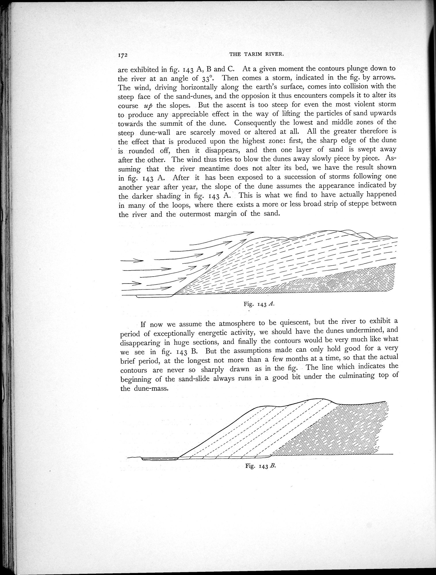
172 THE TARIM RIVER.
are exhibited in fig. 143 A, B and C. At a given moment the contours plunge down to the river at an angle of 33°. Then comes a storm, indicated in the fig. by arrows. The wind, driving horizontally along the earth's surface, comes into collision with the steep face of the sand-dunes, and the opposion it thus encounters compels it to alter its course up the slopes. But the ascent is too steep for even the most violent storm to produce any appreciable effect in the way of lifting the particles of sand upwards towards the summit of the dune. Consequently the lowest and middle zones of the steep dune-wall are scarcely moved or altered at all. All the greater therefore is the effect that is produced upon the highest zone: first, the sharp edge of the dune is rounded off, then it disappears, and then one layer of sand is swept away after the other. The wind thus tries to blow the dunes away slowly piece by piece. Assuming that the river meantime does not alter its bed, we have the result shown in fig. 143 A. After it has been exposed to a succession of storms following one another year after year, the slope of the dune assumes the appearance indicated by the darker shading in fig. 143 A. This is what we find to have actually happened in many of the loops, where there exists a more or less broad strip of steppe between the river and the outermost margin of the sand.
--•■••■•■••••••• l ...••••••
~'
51,
-
7.2 ~~
//i~/j%i~%~~~/ji
_
Fig. 143 A.
If now we assume the atmosphere to be quiescent, but the river to exhibit a period of exceptionally energetic activity, we should have the dunes undermined, and disappearing in huge sections, and finally the contours would be very much like what we see in fig. 143 B. But the assumptions made can only hold good for a very brief period, at the longest not more than a few months at a time, so that the actual contours are never so sharply drawn as in the fig. The line which indicates the beginning of the sand-slide always runs in a good bit under the culminating top of the dune-mass.
Fig. 143 B.
|
Copyright (C) 2003-2019 National Institute of Informatics and The Toyo Bunko. All Rights Reserved.