National Institute of Informatics - Digital Silk Road Project
| |||||||||
|
| Scientific Results of a Journey in Central Asia, 1899-1902 : vol.1 |
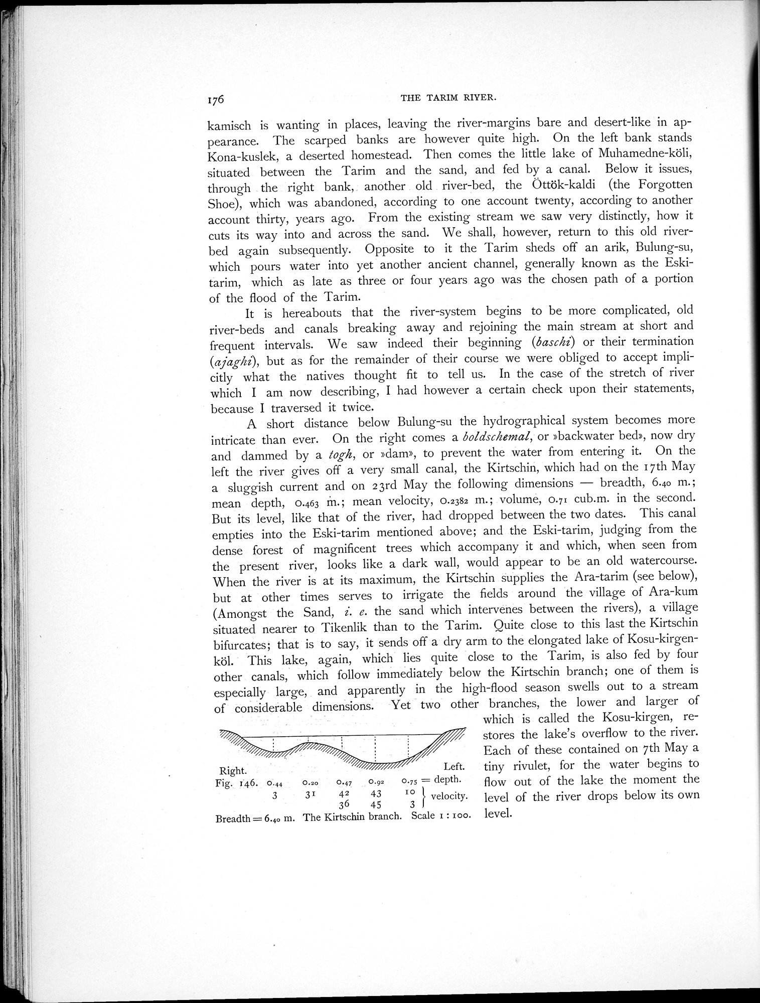 |
| The Kirtschin branch. |
176 THE TARIM RIVER.
kamisch is wanting in places, leaving the river-margins bare and desert-like in appearance. The scarped banks are however quite high. On the left bank stands Kona-kuslek, a deserted homestead. Then comes the little lake of Muhamedne-köli, situated between the Tarim and the sand, and fed by a canal. Below it issues, through the right bank, . another . old . river-bed, the Öttök-kaldi (the Forgotten Shoe), which was abandoned, according to one account twenty, according to another account thirty, years ago. From the existing stream we saw very distinctly, how it cuts its way into and across the sand. We shall, however, return to this old riverbed again subsequently. Opposite to it the Tarim sheds off an arik, Bulung-su, which pours water into yet another ancient channel, generally known as the Eskitarim, which as late as three or four years ago was the chosen path of a portion of the flood of the Tarim.
It is hereabouts that the river-system begins to be more complicated, old river-beds and canals breaking away and rejoining the main stream at short and frequent intervals. We saw indeed their beginning (baschi) or their termination (ajaghi), but as for the remainder of their course we were obliged to accept implicitly what the natives thought fit to tell us. In the case of the stretch of river which I am now describing, I had however a certain check upon their statements, because I traversed it twice.
A short distance below Bulung-su the hydrographical system becomes more intricate than ever. On the right comes a boldschemal, or »backwater bed», now dry and dammed by a Josh, or »dam», to prevent the water from entering it. On the left the river gives off a very small canal, the Kirtschin, which had on the 17th May a sluggish current and on 23rd May the following dimensions — breadth, 6.40 m.; mean depth, 0.463 m. ; mean velocity, 0.2382 m. ; volume, 0.71 cub.m. in the second. But its level, like that of the river, had dropped between the two dates. This canal empties into the Eski-tarim mentioned above; and the Eski-tarim, judging from the dense forest of magnificent trees which accompany it and which, when seen from the present river, looks like a dark wall, would appear to be an old watercourse. When the river is at its maximum, the Kirtschin supplies the Ara-tarim (see below), but at other times serves to irrigate the fields around the village of Ara-kum (Amongst the Sand, i. e. the sand which intervenes between the rivers), a village situated nearer to Tikenlik than to the Tarim. Quite close to this last the Kirtschin bifurcates; that is to say, it sends off a dry arm to the elongated lake of Kosu-kirgenköl. This lake, again, which lies quite close to the Tarim, is also fed by four other canals, which follow immediately below the Kirtschin branch; one of them is especially large, and apparently in the high-flood season swells out to a stream of considerable dimensions. Yet two other branches, the lower and larger of
which is called the Kosu-kirgen, re- stores the lake's overflow to the river. Each of these contained on 7th May a
Right. Left. tiny rivulet, for the water begins to
Fig.. 46. 0:44 0.20 0.47 0.92 0,75 depth. flow out of the lake the moment thep
3 3 42 43 zO
36 45 3 velocity. level of the river drops below its own
~
Breadth= 6.40 m. The Kirtschin branch. Scale z : zoo. level.
|
Copyright (C) 2003-2019 National Institute of Informatics and The Toyo Bunko. All Rights Reserved.