National Institute of Informatics - Digital Silk Road Project
| |||||||||
|
| Scientific Results of a Journey in Central Asia, 1899-1902 : vol.1 |
 |
| Jemischek-kok-akasi, June 3. |
192 THE TARIM RIVER.
vailing direction of the wind throughout the whole country. I was repeatedly assured, that the violence of the wind abates in the beginning of the summer, and that the warmest months of the year are generally very still and calm. At noon I made a little trip in a canoe to the Jätim-tarim and the arm which issues from the Tschivilik-köl. After paddling 38 minutes north-west above Ajagharghan, we reached the confluence of these two rivers; their united currents made a stream considerably larger than that on which we had hitherto been travelling. About eleven years ago a boldschemal was left on the right of the united stream; it still contains an almost ring-shaped pool, separated from the river by merely a narrow isthmus. It bears the name of Paschalik-otak, or the Gnat Place, apparently a very suitable name, for no sooner did the wind drop than the air literally swarmed with mosquitoes and gnats, which, in conjunction with the kökön or »gad-flies», whose, sting burns like fire, plagued us horribly.
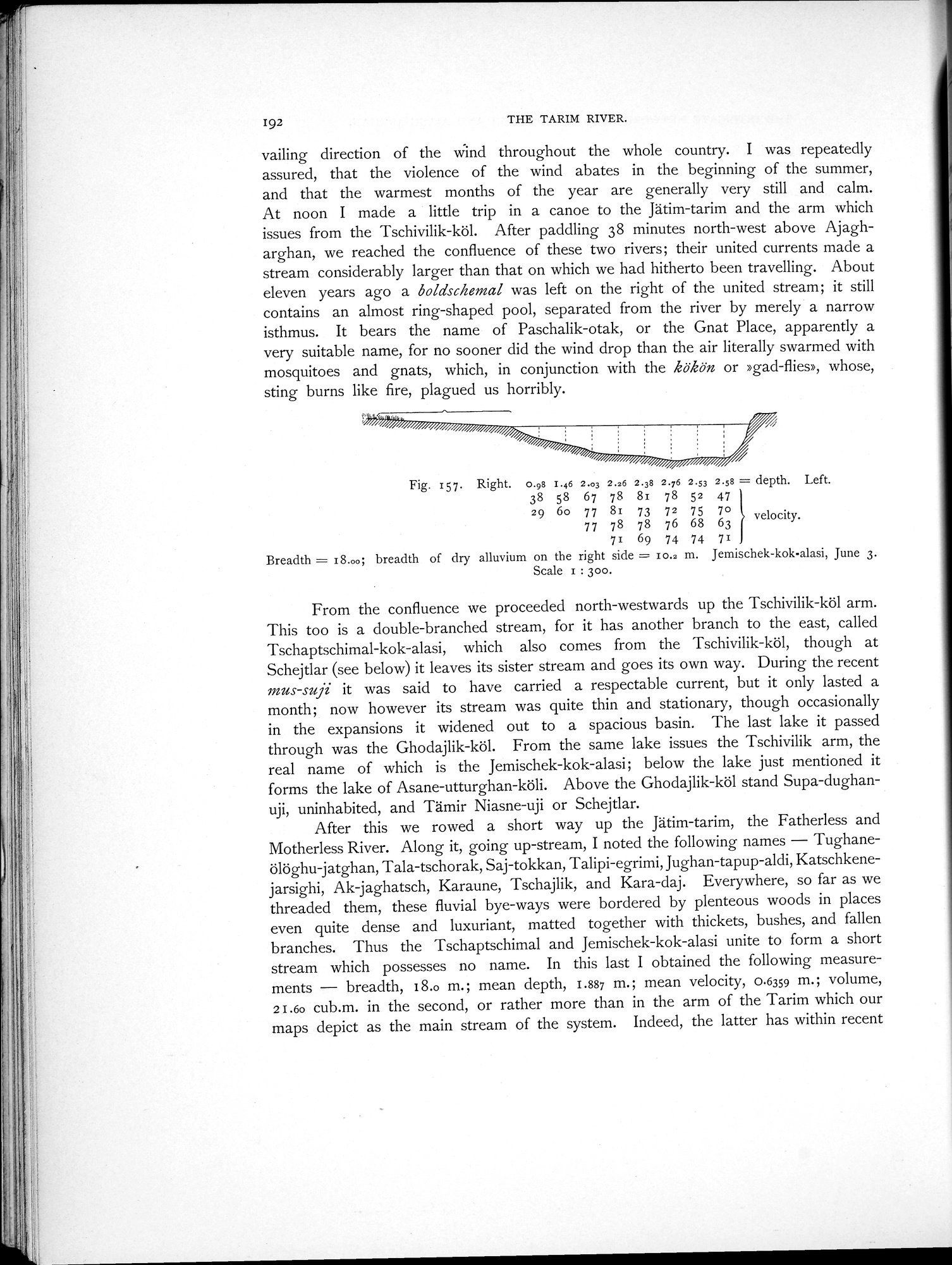
Fig. 157. Right. 0.98 I.46 2.03 2.26 2.38 2.76 2.53 2.58 = depth. Left.
38 58 67 78 81 78 52 47
29 6o 77 81 73 72 75 7ovelocity.
77 78 78 76 68 63
71 69 74 74 71
Breadth = 18.00; breadth of dry alluvium on the right side = 10.2 m. Jemischek-kok-alasi, June 3.
Scale 1 : 300.
From the confluence we proceeded north-westwards up the Tschivilik-köl arm. This too is a double-branched stream, for it has another branch to the east, called Tschaptschimal-kok-alasi, which also comes from the Tschivilik-köl, though at Schejtlar (see below) it leaves its sister stream and goes its own way. During the recent mus-suji it was said to have carried a respectable current, but it only lasted a month; now however its stream was quite thin and stationary, though occasionally in the expansions it widened out to a spacious basin. The last lake it passed through was the Ghodajlik-köl. From the same lake issues the Tschivilik arm, the real name of which is the Jemischek-kok-alasi; below the lake just mentioned it forms the lake of Asane-utturghan-köli. Above the Ghodajlik-köl stand Supa-dughanuji, uninhabited, and Tämir Niasne-uji or Schejtlar.
After this we rowed a short way up the Jätim-tarim, the Fatherless and Motherless River. Along it, going up-stream, I noted the following names — Tughaneölöghu-jatghan, Tala-tschorak, Saj-tokkan, Talipi-egrimi, Jughan-tapup-aldi, Katschkenejarsighi, Ak-jaghatsch, Karaune, Tschajlik, and Kara-daj. Everywhere, so far as we threaded them, these fluvial bye-ways were bordered by plenteous woods in places even quite dense and luxuriant, matted together with thickets, bushes, and fallen branches. Thus the Tschaptschimal and Jemischek-kok-alasi unite to form a short stream which possesses no name. In this last I obtained the following measurements — breadth, 18.o m.; mean depth, 1.887 m.; mean velocity, 0.6359 m.; volume, 2I.6o cub.m. in the second, or rather more than in the arm of the Tarim which our maps depict as the main stream of the system. Indeed, the latter has within recent
|
Copyright (C) 2003-2019 National Institute of Informatics and The Toyo Bunko. All Rights Reserved.