National Institute of Informatics - Digital Silk Road Project
| |||||||||
|
| Scientific Results of a Journey in Central Asia, 1899-1902 : vol.1 |
 |
| Lajlik-darja at Camp XXXII; April 21st. |
460 THE TARIM DELTA.
your is to fill up all these lake-basins, and it is only the river-arms which carve their way through it that are able to withstand it. Here the steep leeward flanks are regularly turned towards the south-west, not towards the west-south-west, as they usually are in the Desert of Tschertschen. In the Desert of Lop the prevailing wind appears to blow from the north-east, and still farther west to incline towards the west-south-west, so that its general course appears to describe a gentle curve round by the west.
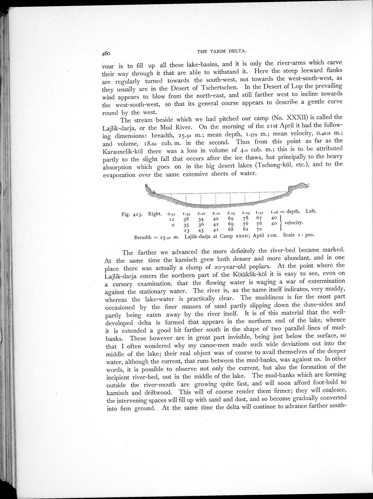
The stream beside which we had pitched our camp (No. XXXII) is called the Lajlik-darja, or the Mud River. On the morning of the 2 I st April it had the following dimensions: breadth, 25.52 m.; mean depth, 1.579 m.; mean velocity, 0.4616 m.; and volume, 18.60 cub. m. in the second. Thus from this point as far as the Karaunelik-köl there was a loss in volume of 4.0 cub. m.; this is to be attributed partly to the slight fall that occurs after the ice thaws, but principally to the heavy absorption which goes on in the big desert lakes (Tschong-köl, etc.), and to the evaporation over the same extensive sheets of water.
Fig. 403. Right.0.77 I.93 2.26 2.22 2.:5 2.03 1.97 r.os = depth. Left.
I2 38 34 40 69 78 67 40
o 35 36 42 69 76 76 4o r velocity.
23 43 41 68 62 7o
Breadth = 25.52 m. Lajlik-darja at Camp xxxii; April 21st. Scale i : 300.
The farther we advanced the more definitely the river-bed became marked. At the same time the kamisch grew both denser and more abundant, and in one place there was actually a clump of 20-year-old poplars. At the point where the Lajlik-darja enters the northern part of the Kötäklik-köl it is easy to see, even on a cursory examination, that the flowing water is waging a war of extermination against the stationary water. The river is, as the name itself indicates, very muddy, whereas the lake-water is practically clear. The muddiness is for the most part occasioned by the finer masses of sand partly slipping down the dune-sides and partly being eaten away by the river itself. It is of this material that the well-developed delta is formed that appears in the northern end of the lake, whence it is extended a good bit farther south in the shape of two parallel lines of mud-banks. These however are in great part invisible, being just below the surface, so that I often wondered why my canoe-men made such wide deviations out into the middle of the lake; their real object was of course to avail themselves of the deeper water, although the current, that runs between the mud-banks, was against us. In other words, it is possible to observe not only the current, but also the formation of the incipient river-bed, out in the middle of the lake. The mud-banks which are forming outside the river-mouth are growing quite fast, and will soon afford foot-hold to kamisch and driftwood. This will of course render them firmer; they will coalesce, the intervening spaces will fill up with sand and dust, and so become gradually converted into firm ground. At the same time the delta will continue to advance farther south-
|
Copyright (C) 2003-2019 National Institute of Informatics and The Toyo Bunko. All Rights Reserved.