国立情報学研究所 - ディジタル・シルクロード・プロジェクト
| |||||||||
|
| Across Asia : vol.1 | |
| アジア横断 : vol.1 |
 |
|
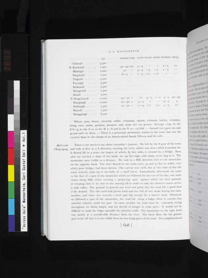
| tja | C. G. MANNERHEIM annual crop cattle horses mules donkeys sheep | ||||||
| Chihsali | 4,50o |
|
|
|
|
|
| |
| W Kuohsiali , | I,000 | 30-40 tan | 3-4 | I | I | 2-3 | 10 | |
| Mafangli | 2,000 | 20 | » | 3-4 | 1/3 | I/3 | 2-3 | — |
| Pingshuili | I,000 | 8-9 | » | 2-3 | I /IO |
| I |
|
| Tingtuli | 4,50o |
|
|
|
|
|
|
|
| Fuyangli | 3,50o |
|
|
|
|
|
|
|
| Kukuanli | 5,50o |
|
|
|
|
|
|
|
| Shyngtseili | 2,50o |
|
|
|
|
|
|
|
| Sienili | 3,000 |
|
|
|
|
|
|
|
| N Wingchuenli | I o,000 | 40-50 | » | 10 | 4-5 | I —2 | 4-5 | 30-40 |
| Hueipingli | 10,000 | 20-30 | » | 4-5 | 1 | 1 | 4-5 | 4 |
| Hsiliangli | 5,50o | I0-20 | » | 2-3 | 1 /2 | 1 /2 | 4-5 | I0 |
| Peineili | 2,50o |
|
|
|
|
|
|
|
| Hsingpingli | 8,50o |
|
|
|
|
|
|
|
April 22nd. Cheng-ngang.
Wheat, peas, beans, mustard, millet, tchumiza, opium, tchoumi, barley, tchinkho, hemp, oats, maize, gaolyan, potatoes and some rice are grown. Average crop: in the E 8-9, in the S Io, in the W 7-8 and in the N 12-13 fold. — Annual tax 3,90o tan and 30,70o taels in silver. — There is a protestant missionary station in the town that has for 13 years been in the charge of an Americanised Swede Nilsson and his wife.
There is not much to say about yesterday's journey. We left by the S gate of the town and rode at first in a S direction, crossing the river, which was now called Lunchow ho. It flowed SE in 3 arms, the largest of which, 85 feet wide, is crossed by a bridge. Soon after we reached a slope of the bank, 20-30 feet high, with many caves dug in it. The mountains were visible at a distance. We rode in a SSE direction over to the mountains on the opposite bank. The river flowed in two main arms, 40 and 5o feet in width, over which poor bridges had been thrown. The current was swift, but at this time of day the water scarcely came up to the belly of a small horse. Immediately afterwards we came to the foot of a spur of the mountains which we followed for the rest of the day, our main course being SSE, either crossing a projecting spur, against which the river pressed, or creeping close to its foot or else moving off in order to take the shortest course across a wide valley. The ground in general was level and good, but the road left a good deal to be desired. The soft earth had grown hard and was full of ruts made during the rainy weather, and there was scarcely a level spot big enough for a horse's hoof. Whenever we followed a spur of the mountains, the road led along a ledge, often so narrow that wheeled vehicles could not pass. In rainy weather the road must be extremely trying throughout its whole length, and not devoid of danger in some parts. It would not be difficult to make the ledges passable for wheeled traffic. The mountains on the right bank run mostly at a considerable distance from the river. The latter flows for the greater part so far off that it is not visible from the low-lying parts of the road. The neighbourhood
)6o8(
|
Copyright (C) 2003-2019
National Institute of Informatics(国立情報学研究所)
and
The Toyo Bunko(東洋文庫). All Rights Reserved.
本ウェブサイトに掲載するデジタル文化資源の無断転載は固くお断りいたします。