National Institute of Informatics - Digital Silk Road Project
| |||||||||
|
| Report of a Mission to Yarkund in 1873 : vol.1 |
 |
| ROUTE XIV. Route from Karghalik viâ KHOTAN to Tankse. Authority Captain Trotter from Pundit Kishen Singh.-(Continued.) |
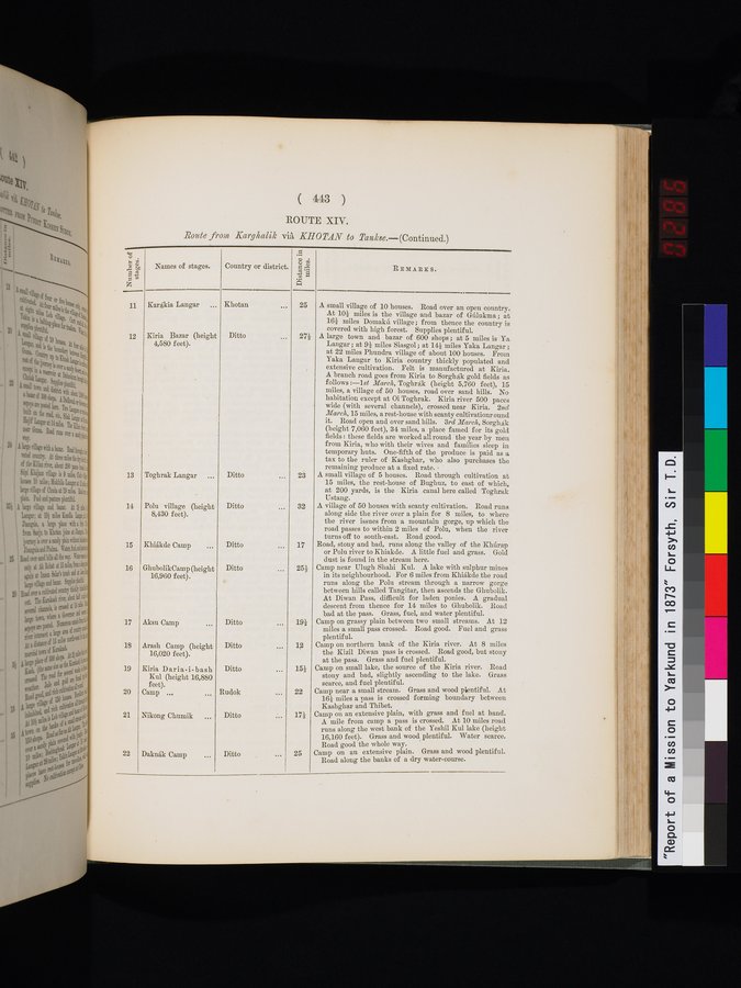
( 443 )
ROUTE XIV.
Route from Kary1 alik via KHOTAN to Tank8e.—(Continued.)
| Number of stages. | Names of stages. | Country or district. | Distance in miles. | REMARKS. |
| 11 12 13 14 15 16 17 18 19 20 21 22 | Kar$kia Langar ... Kiria Bazar (height 4,580 feet). ' Toghrak Langar ... Polu village (height 8,430 feet). Khiâ,kde Camp ... GhubolikCamp (height 16,960 feet). Aksu Camp ... Arash Camp (height 16,020 feet). Kiria Daria-i-bash Kul (height 16,880 feet). Camp ... .., Nikong Chumik ... Daknâk Camp ... | Khotan ,.. Ditto ... Ditto ... Ditto ... Ditto ... Ditto ... Ditto .., Ditto ... Ditto... Rudok ... Ditto ... Ditto ... | 25 272 23 32 17 252 i92 12 152 22 172 25 | A small village of 10 houses. Road over an open country. At 102 miles is the village and bazar of Gûlukma; at 162 miles Domakû village ; from thence the country is covered with high forest. Supplies plentiful. A large town and bazar of 600 shops ; at 5 miles is Ya Langar ; at 92 miles Siasgol; at 142 miles Yaka Langar; at 22 miles Phundra village of about 100 houses. From extensive cultivation. Felt is manufactured at Kiria. miles, a village of 50 houses, road over sand hills. No habitation except at Oi Toghrak. Kiria river 500 paces wide (with several channels), crossed near Kiria. 2nd March, 15 miles, a rest-house with scanty cultivationround it. Road open and over sand bills. 3rd March, Sorghak temporary huts. One-fifth of the produce is paid as a A small village of 5 houses. Road through cultivation at at 200 yards, is the Kiria canal here called Toghrak A village of 50 houses with scanty cultivation. Road runs turns off to south-east. Road good. Road, stony and bad, runs along the valley of the Khûrap or Polu river to Khiakde. A little fuel and grass. Gold Camp near Ulugh Shahi Kul. A lake with sulphur mines At Diwan Pass, difficult for laden ponies. A gradual descent from thence for 14 miles to Ghubolik. Road bad at the pass. Grass, fuel, and water plentiful. Camp on grassy plain between two small streams. At 12 miles a small pass crossed. Road good. Fuel and grass Camp on northern bank of the Kiria river. At 8 miles the Kizil Diwan pass is crossed. Road good, but stony at the pass. Grass and fuel plentiful. Camp on small lake, the source of the Kiria river. Road stony and bad, slightly ascending to the lake. Grass scarce, and fuel plentiful. Camp near a small stream. Grass and wood plentiful. At Camp on an extensive plain, with grass and fuel at hand. A mile from camp a pass is crossed. At 10 miles road 16,160 feet). Grass 4nd wood plentiful. Water scarce. Camp on an extensive plain. Grass and wood plentiful. |
|
Copyright (C) 2003-2019 National Institute of Informatics and The Toyo Bunko. All Rights Reserved.