National Institute of Informatics - Digital Silk Road Project
| |||||||||
|
| Report of a Mission to Yarkund in 1873 : vol.1 |
 |
| ROUTE XIV. Route from Karghalik viâ KHOTAN to Tankse. Authority Captain Trotter from Pundit Kishen Singh.-(Concluded.) |
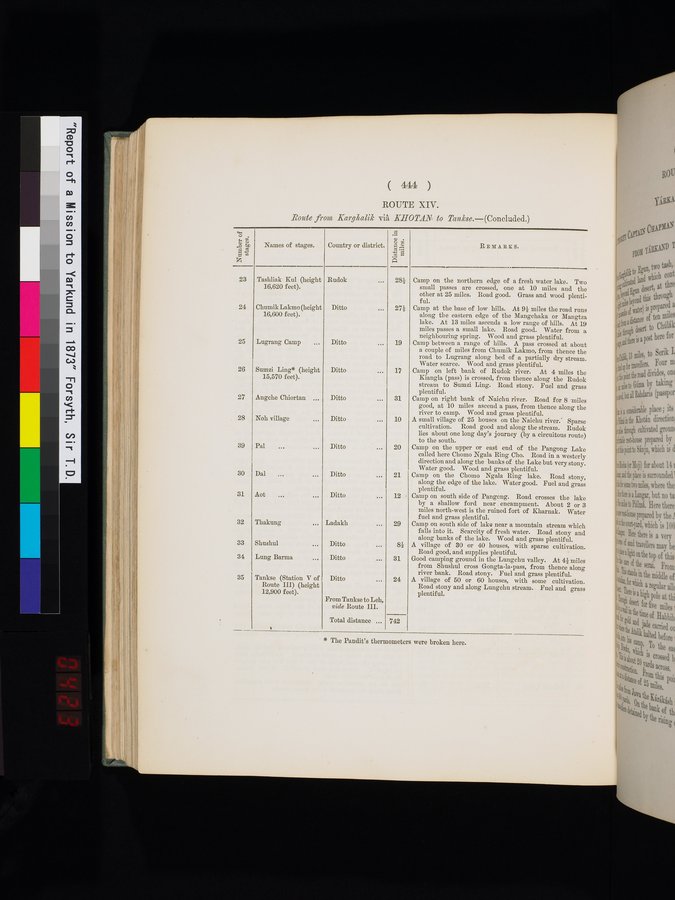
( 444 )
ROUTE XIV.
.Route from Kargltalik via KHOTAN to Tankee.---(Concluded.)
Names of stages.
REMARKS.
Tashliak Kul (height 16,620 feet).
Chumik Lakmo (height 16,600 feet).
25
Lugrang Camp ...
26
Sumzi Ling* (height 15,570 feet).
27
28
Angche Chiortan ...
Noh village
39
Pal
30
Dal ... ...
31
Aot
32
Thakung
33
Shushul
34
Lung Barma
35
Country or district.
Rudok ... 28f
Ditto ... 27/
Ditto ... 19
Ditto ... 17
Ditto ... 31
Ditto ... 10
Ditto ... 20
Ditto ... 21
Ditto ... 12
Ladakh ... 29
Ditto ... 81
Ditto 31
Ditto 24
Tankse (Station V of Route III) (height 12,900 feet).
Camp on the northern edge of a fresh water lake. Two small passes are crossed, one at 10 miles and the other at 25 miles. Road good. Grass and wood plentiful.
Camp at the base of low hills. At 91 miles the road runs along the eastern edge of the Mangchaka or Mangtza lake. At 13 miles ascends a low range of hills. At 19 miles passes a small lake. Road good. Water from a neighbouring spring. Wood and grass plentiful.
Camp between a range of hills. A pass crossed at about a couple of miles from Chumik Lakmo, from thence the road to Lugrang along bed of a partially dry stream. Water scarce. Wood and grass plentiful.
Camp on left bank of Rudok river. At 4 miles the Kiangla (pass) is crossed, from thence along the Rudok stream to Sumzi Ling. Road stony. Fuel and grass plentiful.
Camp on right bank of Naichu river. Road for 8 miles good, at 10 miles ascend a pass, from thence along the river to camp. Wood and grass plentiful.
A small village of 25 houses on the Naichu river.' Sparse cultivation. Road good and along the stream. Rudok lies about one long day's journey (by a circuitous route) to the south.
Camp on the upper or east end of the Pangong Lake called here Chomo Ngala Ring Cho. Road in a westerly direction and along the banks of the Lake but very stony. Water good. Wood and grass plentiful.
Camp on the Chomo Ngala Ring lake. Road stony, along the edge of the lake. Water good. Fuel and grass plentiful.
Camp on south side of Pangong. Road crosses the lake by a shallow ford near . encampment. About 2 or 3 miles north-west is the ruined fort of Kharnak. Water fuel and grass plentiful.
Camp on south side of lake near a mountain stream which falls into it. Scarcity of fresh water. Road stony and along banks of the lake. Wood and grass plentiful.
A village of 30 or 40 houses, with sparse cultivation. Road good, and supplies plentiful.
Good camping ground in the Lungchu valley. At 41 miles from Shushul cross Gongta-la-pass, from thence along river bank. Road stony. Fuel and grass plentiful.
A village of 50 or 60 houses, with some cultivation. Road stony and along Lungchu stream. Fuel and grass plentiful.
From Tankse to Leh, vide Route III.
Total distance ...
742
* The Pandit's thermometers were broken here.
|
Copyright (C) 2003-2019 National Institute of Informatics and The Toyo Bunko. All Rights Reserved.