国立情報学研究所 - ディジタル・シルクロード・プロジェクト
| |||||||||
|
| Explorations in Turkestan 1903 : vol.1 | |
| トルキスタンの調査 1903年 : vol.1 |
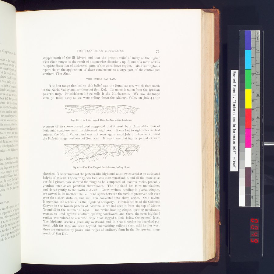 |
| 扁平なBural-bas-tau 南東向きThe Flat-Topped Bural-bas-tau, looking Southeast. | |
| 扁平なBural-bas-tau 南向きThe Flat-Topped Bural-bas-tau, looking South. |
THE TIAN SIIAN MOUNTAINS. 73
steppes north of the Ili River ; and that the present relief of many of the higher Tian Shan ranges is the result of a somewhat disorderly uplift and of a more or less complete dissection of dislocated parts of the worn-down region. Mr. Huntington's report shows the application of these conclusions to a large part of the central and southern Tian Shan.
THE BURAL-BAS-TAU.
The first range that led to this belief was the Bural-bas-tau, which rises north of the Narin Valley and southeast of Son Kul. Its name is taken from the Russian 40-verst map. Friedrichsen (1899) calls it the Mulda-aschu. We saw the range some 50 miles away as we were riding down the Alabuga Valley on July 4 ; the
Fig. 40.—The Flat-Topped Bural-bas-tau, looking Southeast.
evenness of its snow-covered crest suggested that it must be a plateau-like mass of horizontal structure, amid its deformed neighbors. It was lost to sight after we had entered the Narin Valley, and was not seen again until July 9, when we climbed the Kok-tal range northeast of Son Kul. It was there that figures 40 and 41 were
Fig. 41.—The Flat-Topped Bural-bas-tau, looking South.
sketched. The evenness of the plateau-like highland, all snow-covered at an estimated height of at least 12,000 or 13,000 feet, was most remarkable, and all the more so as our field-glasses now showed the range to be composed of massive rocks, probably granites, such as are plentiful thereabouts. The highland has faint undulations, and slopes gently to the north and east. Great ravines, heading in glacial cirques, are carved in its northern flank. The spurs between the ravines preserve their even crest for a short distance, but are then converted into sharp arêtes. One ravine, longer than the others, cuts the highland obliquely. It reminded us of the Colorado
uJ Canyon in the Kanab plateau of Arizona, as we had seen it from the top of Mount
Trumbull in the summer of 1902. One ravine-heading cirque, opening northward, seemed to head against another, opening southward, and there the even highland
60 surface was reduced to a serrate ridge that sagged a little below the general level.
The highland ascends gradually westward, and in that direction its detached por-
140 tions, with flat tops, are seen beyond encroaching valleys ; then, still farther west,
401 these are succeeded by peaks and ridges of ordinary form in the Dongus-tau range
iø south of Son Kul.
|
Copyright (C) 2003-2019
National Institute of Informatics(国立情報学研究所)
and
The Toyo Bunko(東洋文庫). All Rights Reserved.
本ウェブサイトに掲載するデジタル文化資源の無断転載は固くお断りいたします。