国立情報学研究所 - ディジタル・シルクロード・プロジェクト
| |||||||||
|
| Explorations in Turkestan 1903 : vol.1 | |
| トルキスタンの調査 1903年 : vol.1 |
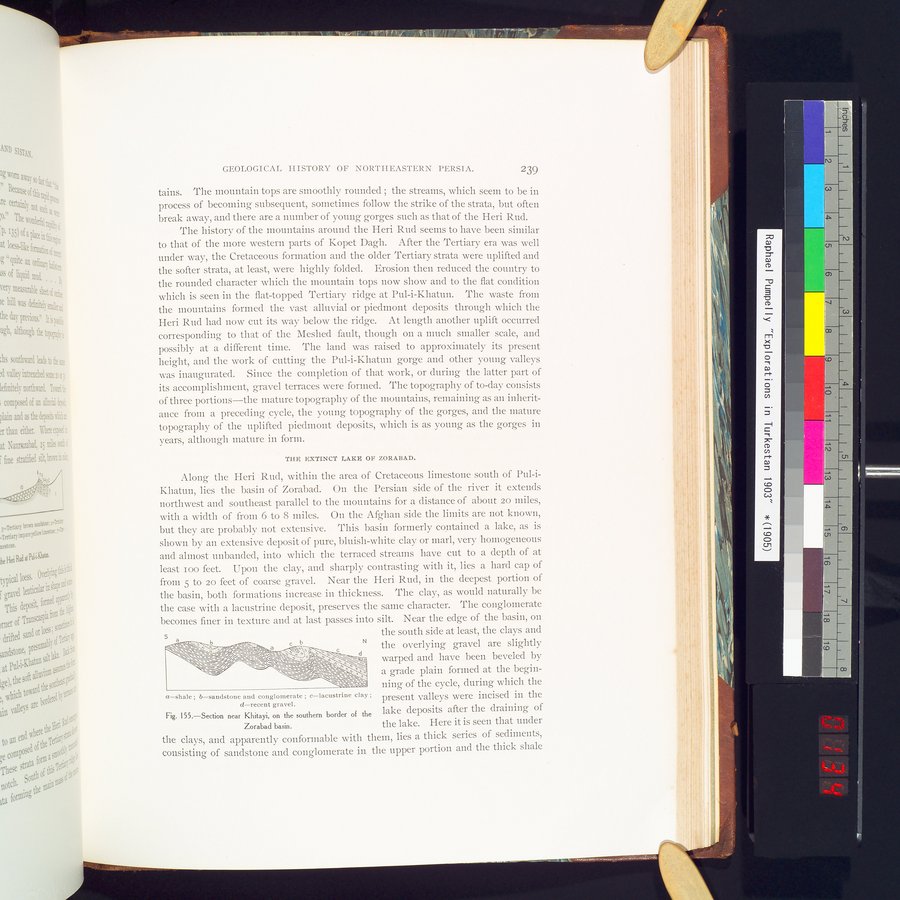 |
| Khitayi近郊の断面 Zorabad盆地の南の境界にある 頁岩Section near Khitayi, on the southern border of the Zorabad basin. Shale. | |
| Khitayi近郊の断面 Zorabad盆地の南の境界にある 砂岩と礫岩Section near Khitayi, on the southern border of the Zorabad basin. Sandstone and conglomerate. | |
| Khitayi近郊の断面 Zorabad盆地の南の境界にある 湖成粘土Section near Khitayi, on the southern border of the Zorabad basin. Lacustrine clay. | |
| Khitayi近郊の断面 Zorabad盆地の南の境界にある 新しい砂利Section near Khitayi, on the southern border of the Zorabad basin. Recent gravel. |
GEOLOGICAL HISTORY OF NORTHEASTERN PERSIA. 239
tains. The mountain tops are smoothly rounded ; the streams, which seem to be in process of becoming subsequent, sometimes follow the strike of the strata, but often break away, and there are a number of young gorges such as that of the Heri Rud.
The history of the mountains around the Heri Rud seems to have been similar to that of the more western parts of Kopet Dagli. After the Tertiary era was well under way, the Cretaceous formation and the older Tertiary strata were uplifted and the softer strata, at least, were highly folded. Erosion then reduced the country to the rounded character which the mountain tops now show and to the flat condition which is seen in the flat-topped Tertiary ridge at Pul-i-Khatun. The waste from the mountains formed the vast alluvial or piedmont deposits through which the Heri Rud had now cut its way below the ridge. At length another uplift occurred corresponding to that of the Meshed fault, though on a much smaller scale, and possibly at a different time. The land was raised to approximately its present height, and the work of cutting the Pul-i-Khatun gorge and other young valleys was inaugurated. Since the completion of that work, or during the latter part of its accomplishment, gravel terraces were formed. The topography of to-day consists of three portions—the mature topography of the mountains, remaining as an inheritance from a preceding cycle, the young topography of the gorges, and the mature topography of the uplifted piedmont deposits, which is as young as the gorges in years, although mature in form.
THE >~%TINCT LAKE OF ZORABAD.
Along the Heri Rud, within the area of Cretaceous limestone south of Pul-iKhatun, lies the basin of Zorabad. On the Persian side of the river it extends northwest and southeast parallel to the mountains for a distance of about zo miles, with a width of from 6 to 8 miles. On the Afghan side the limits are not known, but they are probably not extensive. This basin formerly contained a lake, as is shown by an extensive deposit of pure, bluish-white clay or marl, very homogeneous and almost unbanded, into which the terraced streams have cut to a depth of at least ioo feet. Upon the clay, and sharply contrasting with it, lies a hard cap of from 5 to 20 feet of coarse gravel. Near the Heri Rud, in the deepest portion of the basin, both formations increase in thickness. The clay, as would naturally be the case with a lacustrine deposit, preserves the same character. The conglomerate becomes finer in texture and at last passes into silt. Near the edge of the basin, on
the south side at least, the clays and
. \~ a c b ° _ N the overlying gravel are slightly
~~~~/~//\\~~~\\ß:öÌ 'a..::
~_~~/i-\\~i.~\~~`_~~~~ ° ' ' warped and have been beveled by
a grade plain formed at the begirr-
:. ,, ~ ping of the cycle, during which the
a=shale ; b=sandstone and conglomerate ; c=lacustrine clay ; present valleys were incised in the d=recent gravel.
Fig. 155.—Section near Khitayi, on the southern border of the lake deposits after the draining of
Zorabad basin. the lake. Here it is seen that under
the clays, and apparently conformable with them, lies a thick series of sediments, consisting of sandstone and conglomerate in the upper portion and the thick shale
|
Copyright (C) 2003-2019
National Institute of Informatics(国立情報学研究所)
and
The Toyo Bunko(東洋文庫). All Rights Reserved.
本ウェブサイトに掲載するデジタル文化資源の無断転載は固くお断りいたします。