National Institute of Informatics - Digital Silk Road Project
| |||||||||
|
| Explorations in Turkestan : Expedition of 1904 : vol.2 |
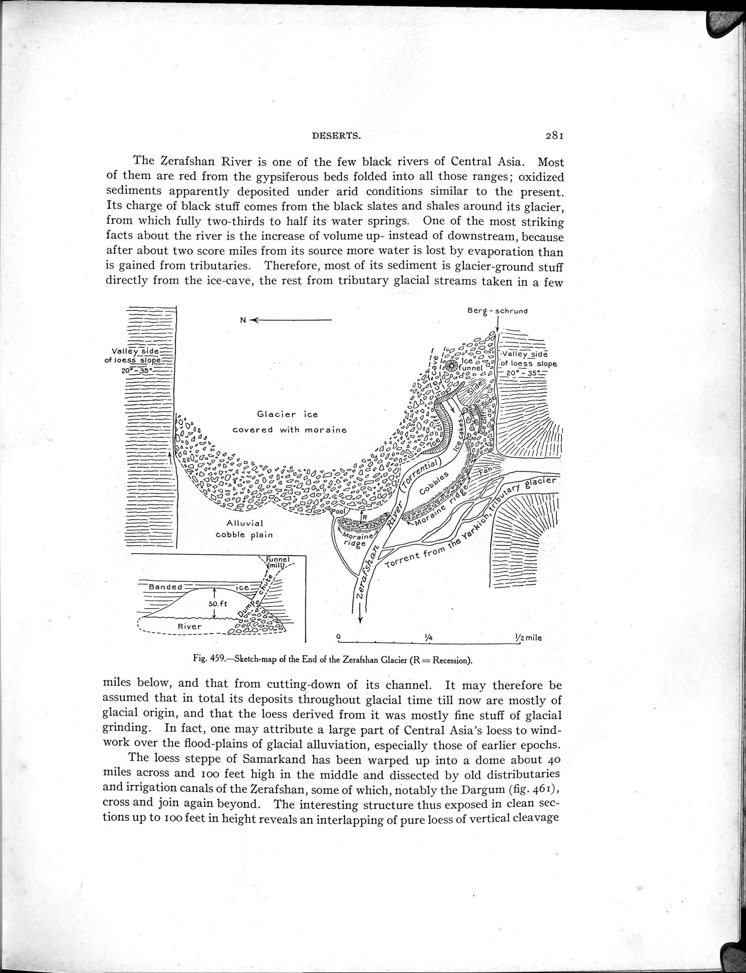 |
| Sketch-map of the End of the Zerafshan Glacier (R=Recession). |
DESERTS. 28I
The Zerafshan River is one of the few black rivers of Central Asia. Most of them are red from the gypsiferous beds folded into all those ranges; oxidized sediments apparently deposited under arid conditions similar to the present. Its charge of black stuff comes from the black slates and shales around its glacier, from which fully two-thirds to half its water springs. One of the most striking facts about the river is the increase of volume up- instead of downstream, because after about two score miles from its source more water is lost by evaporation than is gained from tributaries. Therefore, most of its sediment is glacier-ground stuff directly from the ice-cave, the rest from tributary glacial streams taken in a few
Berg - schrund
~
N
co
Vallé side= ~ 1op ~ ó°o ó --.1-...,-.=—. --
%"_ l ~ IGooc oo~ p -Valley sidó
of loess slope= 1~ lo Ice o da4 of loess slope
m lo,,m: funnel n
20_33° OAéOIDOOÓpóO~pD ^20°~35_
Ot) ó1 Ja ~UD:%€%p° - —
~
V., 0\ ~o`~y ~y~/~~ _ ~
_ âp°ó _~ i ~o~'.a• ~~--r _
, 9~~ 0 .~t.~-~ -
e40 0 s; 2~ 0. -~~
Glacier ice ~7o aa -~~
'06r,
s s`.) O o ~ ~ ~
— Dv a9p0 e uapo~: dl d . e . 0 /~Ali;
— ' Oa covered with moraine D o°~.4-=O0. -. 4 eb °Qo ~t U ~a00 ~O /.G°04 O ó sßo~o ° 4 QO~\ . ~0O~°do ~ /// ~1 ----- 6Q°OQ000 0 0 °~0..0~°.,w~ ~ ?~oo~`C~///1111'~~,
~aa0o ~ ~ W. 4 0 4v Oo 00~ ~
11 ~oo ~° °D °</ ~ ao O O°o'
~Qi 6°0. g°:4~~~~QO~°O"QQ° OAA44a~ 00~1
\ , oa o a o op. o 0 0. 4
OaN1O~°°.o00oâoo°ßdoQoPo°~ooa1 0 ~~~ ..~o>v~~.~ ,taaer
\~Q°°v~ó~óc0 óöv QQCJa0O°0ócó40Oóó 0i~
\O_0.0 O~O~~OQd óQ44° oOÓdo °QO~/
~S ~°avv~°~ooÌ °~~
0
Alluvial
cobble plain
\Funnel
~(millj.
ice
—Banded
50.ft 'Re
Oó óoc',
River ó~oó~,°_° p.,
OOQO-DO_o
o
y4
%z mile
Fig. 459.—Sketch-map of the End of the Zerafshan Glacier (R = Recession).
miles below, and that from cutting-down of its channel. It may therefore be assumed that in total its deposits throughout glacial time till now are mostly of glacial origin, and that the loess derived from it was mostly fine stuff of glacial grinding. In fact, one may attribute a large part of Central Asia's loess to wind-work over the flood-plains of glacial alluviation, especially those of earlier epochs.
The loess steppe of Samarkand has been warped up into a dome about 4o miles across and zoo feet high in the middle and dissected by old distributaries and irrigation canals of the Zerafshan, some of which, notably the Dargum (fig. 461), cross and join again beyond. The interesting structure thus exposed in clean sections up to loo feet in height reveals an interlapping of pure loess of vertical cleavage
|
Copyright (C) 2003-2019 National Institute of Informatics and The Toyo Bunko. All Rights Reserved.