National Institute of Informatics - Digital Silk Road Project
| |||||||||
|
| Memoir on Maps of Chinese Turkistan and Kansu : vol.1 |
 |
No.
Sheet
Latitude
Longitude
Height
ground level
Intersected Point
Height
Latitude
Longitude
Station
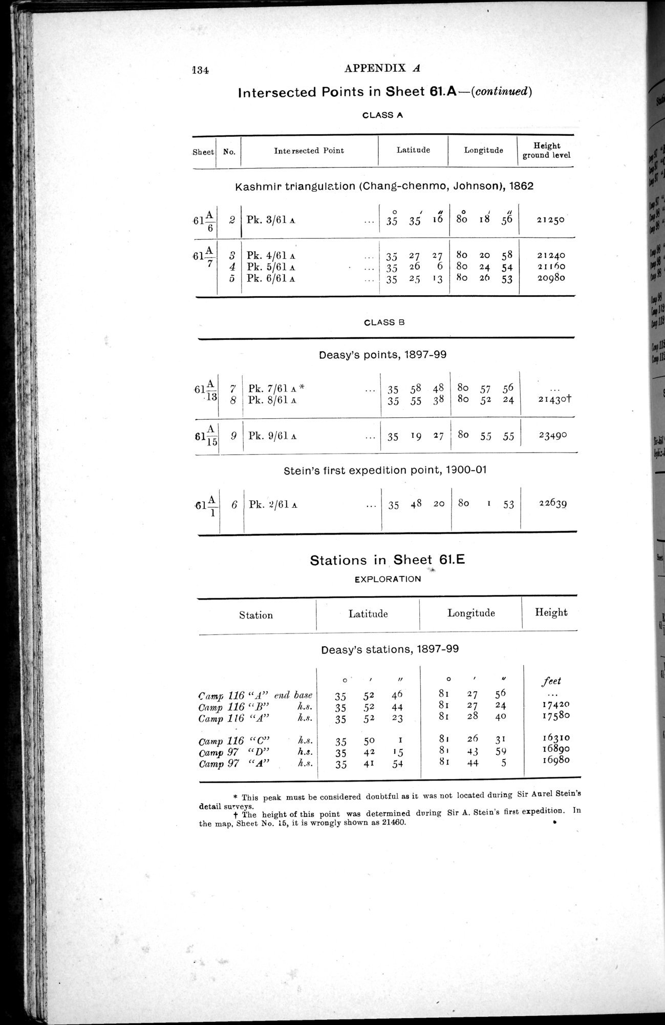
134 APPENDIX A
Intersected Points in Sheet 61.A—(continued)
CLASS A
Kashmir triangulation (Chang-chenmo, Johnson), 1862
| 61:1 | 2 | Pk. 3/61 A |
| ..• | o 35 | , 35 | ii 16 | o | , 18 | ii 56 | 21250 |
| 61 7 3 | 4 5 | Pk. 4/61 A | • | ... ... ... | 35 35 35 | 27 26 25 | 27 6 13 | 8o | 20 24 26 | 58 54 53 | 21240 21160 20980 |
CLASS B
Deasy's points, 1897-99
| .13 6 | 7 8 | Pk. 7/61 A * Pk. 8/61 A | 35 58 48 35 55 38 | 8o 57 56 8o 52 24 | 21430t |
| 6115 |
| Pk. 9/61 A | 35 19 27 8o 55 55 | 23490 | |
| Stein's first expedition point, 1900-01 | |||||
| -61A | 6 | Pk. 2/61 A | 35 48 20 | 8o 1 53 | 22639 |
Stations in Sheet 61.E
EXPLORATION
Deasy's stations, 1897-99
|
|
|
| i | n | 0 |
| 4 | feet |
| Camp 116 "A" end base | 35 | 52 | 46 | 81 | 27 | 56 |
| |
| Camp 116 "B" | I1.s. | 35 | 52 | 44 | 81 | 27 | 24 | 17420 |
| Camp 116 "A" | h.s. | 35 | 52 | 23 | 81 | 28 | 40 | 17580 |
| camp 116 "C" | h.s. | 35 | 50 | 1 | 81 | 26 | 31 | 16310 |
| Camp .97 "D" | h.s. | 35 | 42 | 15 | 81 | 43 | 59 | 16890 |
| Camp 97 "A" | h.s. | 35 | 41 | 54 | 81 | 44 | 5 | 1698o |
* This peak must be considered doubtful as it was not located during Sir Anrel Stein's detail surveys.
t The height of this point was determined during Sir A. Stein's first expedition. In
the map, Sheet No. 16, it is wrongly shown as 21460. •
|
Copyright (C) 2003-2019 National Institute of Informatics and The Toyo Bunko. All Rights Reserved.