国立情報学研究所 - ディジタル・シルクロード・プロジェクト
| |||||||||
|
| Memoir on Maps of Chinese Turkistan and Kansu : vol.1 | |
| 中国領トルキスタンおよび甘粛の地図に関する覚書 : vol.1 |
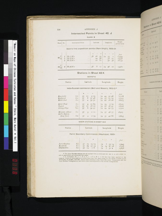 |
116 APPENDIX A
Intersected Points in Sheet 42. J
CLASS B
| Sheet | No. | Intersected Point | Latitude | Longitude | Height |
Stein's first expedition points (Ram Singh), 1900-01
4NJ
15
4216
2
1
3
4
Pk.1/42 a
Pk.2/42 a Pk.3/42 a
Pk.4/42 a
, „
38 26 55
24 38
22 II
38 8 17
ri
74 55 I
58 27
50 56
74 46 22
feet
1599.9
15446
16142
15461
Stations in Sheet 42.K
GEODETIC
Station Latitude Longitude Height
Indo-Russian connexion (Bell and Mason), 1912-13
|
|
|
|
|
| o | • | „ | feet |
| Karalcokli | h.s. | 37 | 12 | 9'05 | 74 | 44 | 30.98 | 17708 |
| K?tktnrnk |
| 37 | 8 | 37'48 | 74 | 37 | 27. 12 | 17237 |
| Kilik East | h.s. | 37 | 4 | 39'31 | 74 | 42 | 28'08 | 18203 |
| Kilik West | 1r...s. | 37 | 4 | 12.83 | 74 | 39 | 3'72 | 18020 |
| Tomtek | h.s. | 37 | II | 18.02 | 74 | 58 | 58'47 | 18608 |
| Jaliiny Jilya | ‘h.s. | 37 | 6 | 59'97 | 74 | 49 | 42'73 | 17510 |
| Mintaka Akksai | 11.s. | 37 | 5 | 0.00 | 74 | 57 | 46'77 | 16907 |
| Bell's Station (Lnp Gaz) | 11.s. | 37 | 4 | 2.79 | 74 | 51 | 42'86 | 17695 |
MINOR STATIONS IN SHEET 42.K
Station Latitude Longitude Height
Pamir Boundary Commission (Wauhope), 1895t
|
|
| O |
| M | o |
| „ | feet |
| Jarti-Gnmbaz | h.s. | 37 | 29 | 24'05 | 74 | 6 | 53'14 | 15240 |
| Benderski | h.s. | 37 | 24 | 52'35 | 74 | 14 | 21•38 | 17058 |
| Chakmaktin | h.s. | 37 | 14 | 7'8 | 74 | 7 | 50'4 | 13838 |
* The Indo-Russiap stations are all marked with a circle and dot cut iu a rock either in situ or embedded, and protected by a cairn.
t A correction of À = — 4".7, L = — 3".3, H — + 17(i feet has been applied to the original values of these stations to bring them into the same terms as the values of three points Pk.15/42x, Pk.16/42x, Pk3/42o, which were common to the Ynmir Boundary Commission and the I ndo-Russian 'triangulation, and which have been adjusted to the Indian triangulation.
|
Copyright (C) 2003-2019
National Institute of Informatics(国立情報学研究所)
and
The Toyo Bunko(東洋文庫). All Rights Reserved.
本ウェブサイトに掲載するデジタル文化資源の無断転載は固くお断りいたします。