国立情報学研究所 - ディジタル・シルクロード・プロジェクト
| |||||||||
|
| Memoir on Maps of Chinese Turkistan and Kansu : vol.1 | |
| 中国領トルキスタンおよび甘粛の地図に関する覚書 : vol.1 |
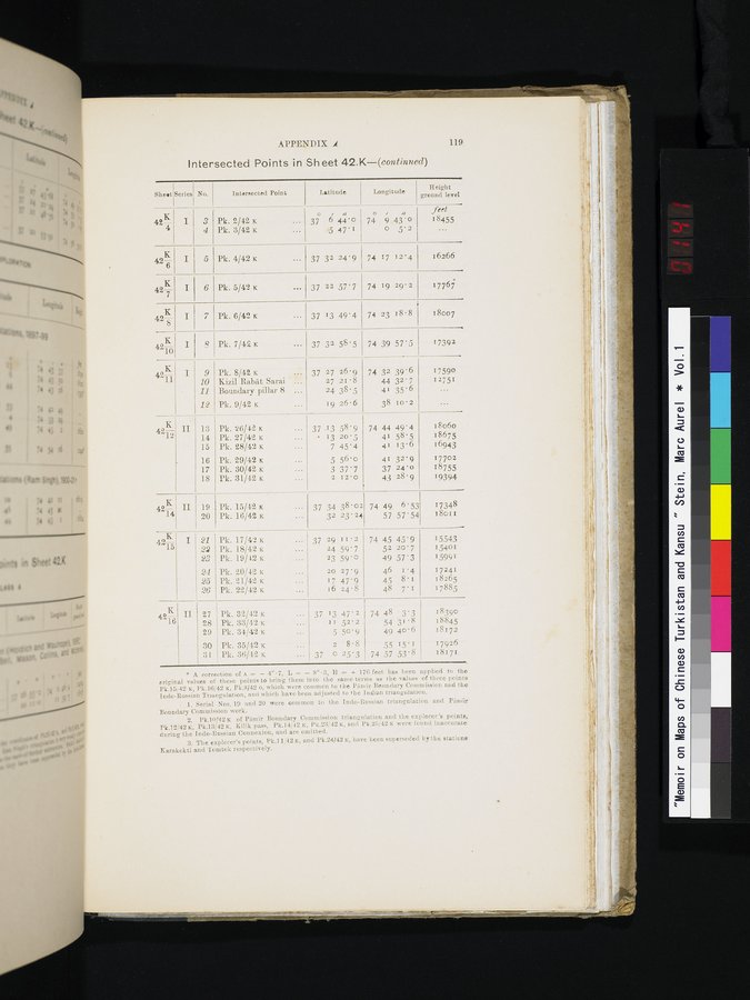 |
| APPENDIX .4 | 119 |
Intersected Points in Sheet 42.K—(eontinuecl)
| Sheet | Series | No. | Intersected Point |
|
| Latitude |
| Longitude | Height | ||
|
|
|
|
|
|
|
|
| feet | |||
| 42— | I | 3 | Pk. 2/42 x | . .. | 37 | 6 | 44 • 0 | 74 | 9 | 43'0 | 18455 |
|
|
| 4 | Pk. 3/42 x | . . . |
| 5 | 47'1 | ~ | 0 | 5'2 | . . . |
| 42Ks | I | 5 | Pk.4/42x | ... | 37 | 32 | 24'9 | 74 | 17 | 12'4 | 16266 |
| 42,E. 7 | I | 6 | Pk. 5/42 x | ... | 37 | 22 | 57'7 | 74 | 19 | 29' 2 | 17767 |
| K 42-g- | I | 7 | Pk. 6/42 K | ... | 37 | 13 | 49'4 | 74 | 23 | 18' 8 | 18007 |
| 4210 | I | ?? | Pk. 7/12 K | ••• | 37 | 32 | 58'5 | 74 | 39 | 57'5 | 17392 |
| 42171 | I | 9 | Pk. 8/42 x | • | 37 | 27 | 26'9 | 74 | 32 | 39'6 | 17590 |
|
|
| 10 | Kizil Rabat Sarai | ... |
| 27 | 21.8 |
| 44 | 32'7 | 12751 |
|
| • | 11 | Boundary pillar 8 | ... |
| 24 | 38'5 |
| 41 | 35'6 |
|
|
|
| 12 | Pk. 9/42 x | . . . |
| 19 | 26.6 |
| 38 | 10'2 | ... |
| 42K | II | 13 | Pk. 26/42 x |
| 37 |
| 58'9 | 74 | 44 | 49'4 | 18o60 |
| .12 |
| 14 | Pk. 27/42 x | ... | • | 13 | 20•5 |
| 41 | 58•5 | 18675 |
|
|
| 15 | Pk. 28/42 x | . . . |
| 7 | 45'4 |
| 41 | 13.6 | 16943 |
|
|
| 16 | Pk. 29/42 x | ... |
| 5 | 56'0 |
| 41 | 32-9 | 17702 |
|
|
| 17 | Pk. 30/42 x | ••. |
| 3 | 37'7 |
| 37 | 24'0 | 18755 |
|
|
| 18 | Pk. 31/42 x | ... |
| 2 | 12'0 |
| 43 | 28•9 | 19394 |
| 4214 | II | 19 | Pk. 15/42x |
| 37 | 34 | 38'02 | 74 | 49 | 6'53 | 17348 |
|
|
| 20 | Pk. 16/42 x | ... |
| 32 | 23.24 |
| 57 | 57'54 | 18o1 t |
| 42K | I | 21 | Pk. 17/42 x | ... | 37 | 29 | 11.2 | 74 | 45 | 45'9 | 15543 |
| 15 |
| 22 | Pk. 18/42 K | ••• |
| 24 | 59'7 |
| 52 | 20'7 | 15401 |
|
|
| 23 | Pk. 19/42 x | ... |
| 23 | 59.0 |
| 49 | 57'3 | 15991 |
|
|
| 24 | Pk. 20/42 x | ... |
| 20 | 27'9 |
| 46 | 1'4 | 17241 |
|
|
| 25 | Pk. 21/42, x |
|
| 17 | 47'9 |
| 45 | 8'1 | 18265 |
|
|
| 26 | Pk. 22/42 K | ... |
| 16 | 24.8 |
| 48 | 7.1 | 17885 |
| 42K | II | 27 | Pk. 32/42 x |
| 37 | 13 | 47' 2 | 74 | 48 | 3'3 | 18390 |
| 16 |
| 28 | Pk. 33/42 K | ... |
| 11 | 52'2 |
| 54 | 31.8 | 18845 |
|
|
| 29 | Pk. 34/42 x | . . . |
| 5 | 50•9 |
| 49 | 40•6 | 18172 |
|
|
| 30 | Pk. 35/42 x | ... |
| 2 | 8.8 |
| 55 | 15.1 | 17926 |
|
|
| 31 | Pk. 36/42 x |
| 37 | 0 | 25'3 | 74 | 57 | 53'8 | 18171 |
* A correction of A •_ — 4"•7, L = — 3"•3, H s + 176 feet has been applied to the original values of these points to bring them into the same terms as the values of three points Pk.15,42 x, Pk.16/42 K, Pk.S/42 o, which were common to the Piimir Boundary Commission and the Indo-Russian Triangulation, and which have been adjusted to the Indian triangulation.
Serial Nos. 19 and 20 were common to the Indo-Russian triangulation and Pamir Boundary Commission work.
Pk.10/42 of Pimir Boundary Commission triangulation and the explorer's points, Pk.12/42 K, Pk.13/42 x, Kilik pass, Pk.14/12 K, Pk.23/42 K, and Pk.25/42 K were found inaccurate during the Indo-Russian Connexion, and are omitted.
The explorer's points, Pk.l 1,142 K, and Pk.24J42 x, have been superseded by the stations Earakokti and 'l'omtek respectively.
|
Copyright (C) 2003-2019
National Institute of Informatics(国立情報学研究所)
and
The Toyo Bunko(東洋文庫). All Rights Reserved.
本ウェブサイトに掲載するデジタル文化資源の無断転載は固くお断りいたします。