国立情報学研究所 - ディジタル・シルクロード・プロジェクト
| |||||||||
|
| Memoir on Maps of Chinese Turkistan and Kansu : vol.1 | |
| 中国領トルキスタンおよび甘粛の地図に関する覚書 : vol.1 |
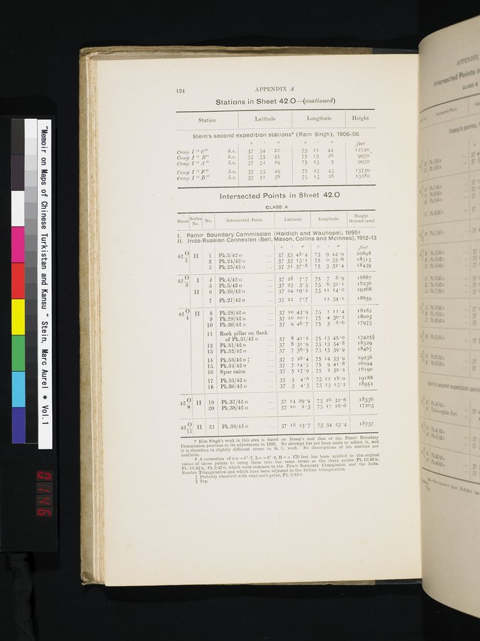 |
124 APPENDIX A
Stations in Sheet 42.0-(continued)
Station Latitude
Longitude
Height
Stein's second expedition stations (Ram Singh), 1906-08
|
|
| o |
| v | o |
| u | feet. |
| Camp 1 " C" | h.8. | 37. | 54 | 22 | 75 | 1I | 44 | 12720 |
| Camp t"B" | h.8. | 37 | 53 | 45 | 75 | 13 | 26 | 9970 |
| Camp I "A" | 4.8. | 37 | 52 | 29 | 75 | 13 | 5 | 9950 |
| Camp 1 " F" | 4.e. | 37 | 55 | 49 | 75 | 25 | 45 | 13730 |
| Camp 1 "D" | 11.8. | 37 | 51 | 58 | 75 | 15 | 28 | 13180 |
Intersected Points in Sheet 42.0
CLASS A
| • Sheet | ||||||
| Series No. | No. | Intersected Point | Latitude | Longitude | Height | |
I. Pamir Boundary Commission (Holdich and Wauhope), 18951
I I. Indo-Russian Connexion (Bell, Mason, Collins and McInnes),1912-13
|
|
|
|
| C | I/ | O • | II | feet. | |
| 42 O | II ~ 1 | Pk.3/42 o |
| 37 | 33 48'4 | 75 9 | 44.9 | 20898 | |
|
| 2 | Pk.24/42 o |
| 37 | 33 15'1 | 75 0 | 55'8 | 18513 | |
|
| ~ 3 | Pk.25/42 o |
| 37 | 31 37'8 | 75 3 | 52'4 | 18439 | |
| 42-0 | I | 4 | Pk.4/42 o |
| 37 | 28 7'7 | 75 7 | 8'9 | 18887 |
|
|
| 5 | Pk.5/42 o |
| 37 | 23 3'5 | 75 6 | 50•I | 18236 |
|
| II | 6 | Pk.26/42 o |
| 37 | 24 19'2 | 75 II | 14.0 | 19268 |
|
|
| 7 | Pk.27/42 o |
| 37 | 22 7.7 | 12 | 54•I | 18659 |
| 42-0 | II | 8 | Pk.28/42 o | . . . | 37 | 10 43'9 | 75 1 | II '4 | 18182 |
|
|
| 9 | Pk.29/42 o | ... | 37 | 10 i o• 1 | 75 4 | 50•2 | 18003 |
|
|
| 10 | Pk.30/42 0 | ... | 37 | 9 46'7 | 75 3 | 6'F | 17975 |
|
|
| 11 | Rock pillar on flank |
|
|
|
|
|
|
|
|
|
| of Pk.31/42 0 |
| 37 | 841 • 2 | 75 13 | 45'0 | 17425§ |
|
|
| 12 | Pk.31/42 o |
| 37 | 8 31.9 | 75 13 | 54'8 | 18329 |
|
|
| 13 | Pk.32/42 o |
| 37 | 7 36'5 | 75 13 | 39'9 | 18467 |
|
|
| 14 | Pk.33/42 o $ |
| 37 | 7 28'4 | 75 14 | 53'9 | 19256 |
|
|
| 15 | Pk.34/42 o |
| 37 | 7 14'5 | 75 9 | 41.•8 | 16194 . |
|
|
| 16 | Spur cairn |
| 37 | 5 17'9 | 75 2 | 30•2 | i61go |
|
| 17 | Pk.35/42 o |
| 37 | 3 4'6 | 75 I2 | 18.0 | 19188 | |
|
| 18 | Pk.36/42 o |
| 37 | 3 4'5 | 75 13 | i5'2 | 18952 | |
| 42- 8 | II | 19 20 | Pk.37/42 o Pk.38/42 o |
| 37 37 | 14 29'9 io 2'5 | 75 16 | 32.6 16.6 | 18336 17203 |
| ~ |
|
|
|
|
|
|
|
| |
| 42 11.I II | 21 | Pk.39/42 o | ••• | 1 37 | 18 23.7 | 75 34 | 23'4 | 18737 | |
* Ram Singh's work in this area is based on Deasy's and that of the Pamir Boundary. Commission previous to its adjustment in 1920. No attempt has yet been made to adjust it, and it is therefore in s ightly different terms to G. 1'. work. No descriptions of his stations are available.
t A correct'on of T=-4"•7, L=-3"•3, H=+ 176 feet has been applied to the original values of these points to bring them into the same terms as the three points Pk.15/42 s. Pk. 16/42 x, Pk.3/42 o, which were common to the Pamir Boundary Commission and the Indo. Russian Triangulation and which have been adjusted to the Indian triangulation.
$ Probably identical with explorer's point, Pk. 6/420.
§ Top.
|
Copyright (C) 2003-2019
National Institute of Informatics(国立情報学研究所)
and
The Toyo Bunko(東洋文庫). All Rights Reserved.
本ウェブサイトに掲載するデジタル文化資源の無断転載は固くお断りいたします。