国立情報学研究所 - ディジタル・シルクロード・プロジェクト
| |||||||||
|
| Memoir on Maps of Chinese Turkistan and Kansu : vol.1 | |
| 中国領トルキスタンおよび甘粛の地図に関する覚書 : vol.1 |
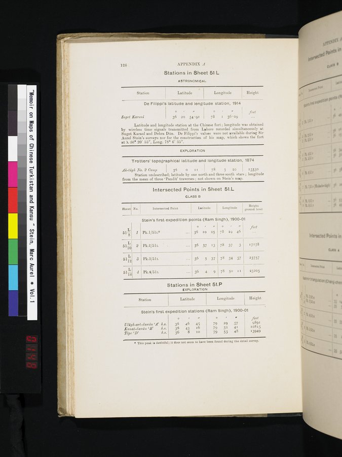 |
126 APPENDIX A
Stations in Sheet 51.L
ASTRONOMICAL
| Station | Latitude | Longitude | Height |
De Filippi's latitude and longitude station, 1914
| Suget Karaul | o 36 | i 20 | " 54'91 | o 78 | I | I/ 36'09 | feet |
Latitude and longitude station at the Chinese fort; longitude was obtained by wireless time signals transmitted from Lahore recorded simultaneously at Suget Karaul and Debra Dan. De Filippi's values were not available during Sir Aurel Stein's surveys nor for the construction of his map, which shows the fort at 7 36° 20' 55", Long. 78° 6' 35".
EXPLORATION
Trotters' topographical latitude and longitude station, 1874
Ak-tâgk No. 2 Camp 36 0 1 1 78 3 20 15330
Station undescribed; latitude by one north and three south stars ; longitude from the mean of three `Pandit' traverses ; not shown on Stein's map.
Intersected Points in Sheet 51.L
CLASS B
| Sheet | No. | Intersected Point | Latitude | Longitude | Height |
Stein's first expedition points (Ram Singh), 1900-01
518
1
feet
36 10 25
° /
78 ~9 46
Pk.1/51L*
36 37
36 5 37
36 4 9
5110 2
L
5112
5116 4
Pk.2/51L
Pk.3/51L
Pk.4/51L
78 37 3
78 34 57
78 50 11
17178
23757
23205
3
Stations in Sheet 51.P
EXPLORATION
Station Latitude Longitude Height
Stein's first expedition stations (Ram Singh), 1900-01
Ulûgh-art-dawân `A' h.s.
guuat-dawci:u `B' h.s.
Tôpe `D' h.s.
o
36 46 4.5
36 .43 16
36 8 10
79 29 57
79 32 41
79 53 48
feet
9891
10815
13949
* This peak is doubtful; it does not seem to have been found during the detail survey.
|
Copyright (C) 2003-2019
National Institute of Informatics(国立情報学研究所)
and
The Toyo Bunko(東洋文庫). All Rights Reserved.
本ウェブサイトに掲載するデジタル文化資源の無断転載は固くお断りいたします。