国立情報学研究所 - ディジタル・シルクロード・プロジェクト
| |||||||||
|
| Memoir on Maps of Chinese Turkistan and Kansu : vol.1 | |
| 中国領トルキスタンおよび甘粛の地図に関する覚書 : vol.1 |
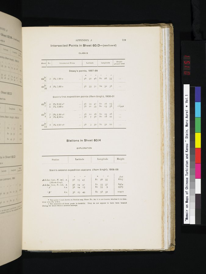 |
APPENDIX A 129
Intersected Points in Sheet 60.D—(continued)
CLASS B
Sheet
No.
Height
ground level
Intersected Point
Latitude Longitude
|
|
| Deasy's points, | 1897-99
|
|
|
| ||
| 601 i 61 | 3 | Pk.1/60 n | 36 | 32 | 46 | 8o | 28, | 35 |
| I |
|
|
|
|
|
|
| |
| 60-1-I | 4 | Pk.7/60D . . . 36 | 33 | 31 8o | 30 | 38 | ||
Stein's first expedition points (Ram Singh), 1900-01
| 60D7 | J | Pk.2/60 n~ |
| 36 | 29 | 47 | 8o | 26 | 15 |
|
|
| 6 | Pk.4/60 n |
| 36 | 2r | 55 | 8o | 23 | 58 | I6542 |
| 60 | 7 | Pk.5/60 ut | ... 36 | 10 | 26 | 80 | 25 | 28 |
| |
|
| 8 | Pk.6/60D | ... j 36 | 7 | 36 | 8o | 16 | 22 |
| |
| fi0~ | 9 Pk.9/60 nt | 36 | 3 | 30 | So | 32 | 22 | |||
Stations in Sheet 60.H
EXPLORATION
| Station | Latitude | Lon gitude | Height |
Stein's second expedition stations (Ram Singh), 1906-08
|
|
| o |
| / v | o |
| u | feet |
| dchehan base, N. end, (8h um-dong) dchchan base, S. end, ` A ' | s. s. h.s. | 36 36 36 | 25 24 24 | 43 41 13 | 81 81 81 | 56 55 55 | 35 57 9 | 8807 8964 9583 |
| `B' | h.s. | 36 | 23 | 49 | 8r | 58 | 52 | 10971 |
* This point is not shown on Stein's map, Sheet No. 14; it is not known whether it is identical with Pk. 3'60 D.
f The existence of these peaks is doubtful. They do not appear to have been located during Sir Anrel Stein's detailed surveys.
|
Copyright (C) 2003-2019
National Institute of Informatics(国立情報学研究所)
and
The Toyo Bunko(東洋文庫). All Rights Reserved.
本ウェブサイトに掲載するデジタル文化資源の無断転載は固くお断りいたします。