国立情報学研究所 - ディジタル・シルクロード・プロジェクト
| |||||||||
|
| Memoir on Maps of Chinese Turkistan and Kansu : vol.1 | |
| 中国領トルキスタンおよび甘粛の地図に関する覚書 : vol.1 |
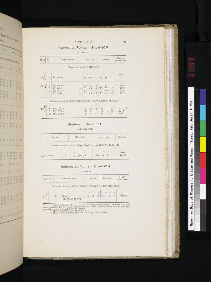 |
APPENDIX A 133
Intersected Points in Sheet 60.P
CLASS B
| Sheet | No. | Intersected Point | Latitude | Longitude | Height |
| 60-- | 1 | Deasy's points,* Pk. 1/60 P | 1897-99
36 50 12 |
83 53 I | feet |
| 6014 | 2 3 | Pk. 2/60 P Pk. 3'/60 | 36 43 24 36 43 9 | 83 53 I 83 58 12 | 13700 |
|
| 4 | Pk. 4/60 P | 36 42 41 | 83 49 49 | 13050 |
|
| 5 | Pk. 5/60 P | 36 42 25 | 83 48 52 | 12900 |
| Stein's second expedition points (Ram Singh), 1906-08 | |||||
| 60— | 6 | Pk. 6/60 P | 36 35 35 | 83 0 34 | 12200 t |
|
| 7 | Pk. 7/60 P | 36 33 5 | 83 0 i8 | 14735 |
|
| 8 | Pk. 8/60 P | 36 31 32 | 83 2 58 | 16606 |
Stations in Sheet 61.A
EXPLORATION
| Station | Latitude J Longitude | Height |
Stein's second expedition station (Lal Singh), 1906-08
Zcail.ik ` D' h.s.
„
35 50 38
0 „
8o 51 48
feet
14486
Intersected Points in Sheet 61.A
CLASS A
| Sheet | No. | Intersected Point. | Latitude | Longitude | Height |
Kashmir triangulation (Chang-chenmo, Johnson), 1862
/ u
1/
feet
61A
35 56 2I
8o 14 to
1 ~ Pk. 1/61 A $ ...
(Muz-tag11 or K 5)
23890
a Deasy's points in 69.D were reported inaccurate in longitude by Râm Singh in 1906-08 and it is possible that these points of his in 60.P, which are not shown on Stein's maps and were therefore probably not located, are also inaccurate.
t Height omitted in map. Sheet No. 19.
*~ 'this peak was originally known in the Survey of India as E 61.
|
Copyright (C) 2003-2019
National Institute of Informatics(国立情報学研究所)
and
The Toyo Bunko(東洋文庫). All Rights Reserved.
本ウェブサイトに掲載するデジタル文化資源の無断転載は固くお断りいたします。