National Institute of Informatics - Digital Silk Road Project
| |||||||||
|
| Memoir on Maps of Chinese Turkistan and Kansu : vol.1 |
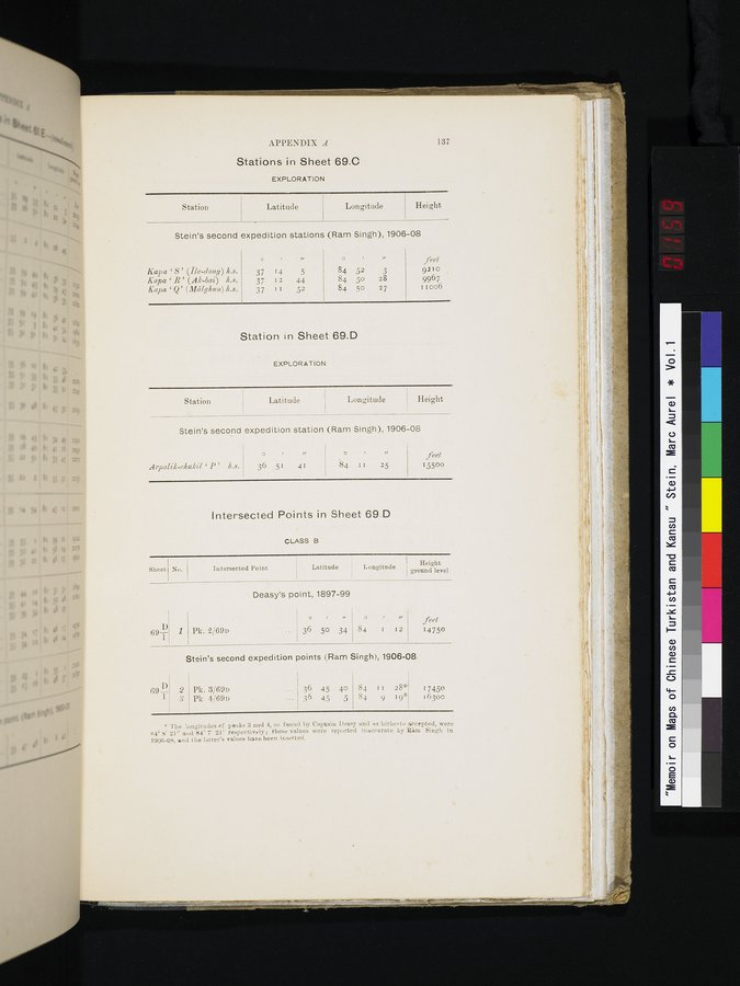 |
APPENDIX A 137
Stations in Sheet 69.0
EXPLORATION
Height
Longitude
| Station | Latitude |
Stein's second expedition stations (Ram Singh), 1906-08
|
|
| o | , | „ | o |
| „ | feet |
| Kapa | S' (Ile-dong) 4.8. | 37 | 14 | 5 | 84 | 52 | 3 | 9210 |
| Kapa | R' (Ak-bai) 4.8. | 37 | 12 | 44 | 84 | 50 | 28 | 9967 |
| Kapa | Q' (Mcilglcun) 4.8. | 37 | I1 | 52 | 84 | 50 | 27 | Iloo6 |
Station in Sheet 69.D
EXPLORATION
Station ; Latitude Longitude Height
| Stein's second expedition station (Ram Singh), 1906-08
o Arpalik-chakil ' P' 11.8. 36 51 41 I 84 1 1 25 | feet 15500 |
Intersected Points in Sheet 69.D
CLASS B
| Sheet) | No. | Height Intersected Point Latitude Longitude ground level | |||
| 691) | 1 | Deasy's point, 1897-99
Pk. 2/69u ~ 50 34 |
84 I 12 | feet 14750 | |
| Stein's second expedition points (Ram Singh), 1906-08. | |||||
| 69 4k | 2 | Pk. 3/69u | 36 45 40 | 84 11 28* | 17450 |
|
| i | Pk. 4/69n | 36 45 5 | 84 9 19* | 16300 |
* The longitudes of peaks 3 and 4, as found by Captain Deasy and as hitherto accepted, were 84° S' 21" and 84' 7' 21" respectively; these values were reported inaccurate by Rim Singh in 1906-08, and the latter's values have been inserted.
|
Copyright (C) 2003-2019 National Institute of Informatics and The Toyo Bunko. All Rights Reserved.