国立情報学研究所 - ディジタル・シルクロード・プロジェクト
| |||||||||
|
| Memoir on Maps of Chinese Turkistan and Kansu : vol.1 | |
| 中国領トルキスタンおよび甘粛の地図に関する覚書 : vol.1 |
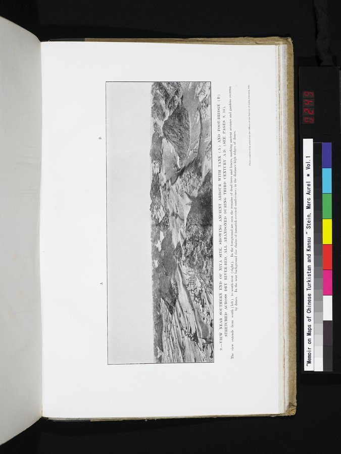 |
| ニヤ遺跡の南端付近の眺め,貯蔵槽(A)のある古代のあずまやと干上がった川床の向こう側まで伸びている歩道橋(B)が見える。これらはすべて西暦3世紀の間に廃棄された(9,14ページ参照)。この写真の視界は南(左)から南西(右)に広がっている。手前には枯れ木と柵の残骸が見えており,古代の通りと砂丘が浸出してきている庭(の位置)を示している。近い背景にはタマリスクで覆われた一続きの砂の堆丘が盛り上がっているのが見える。VIEW NEAR SOUTHERN END OF NIYA SITE, SHOWING ANCIENT ARBOUR WITH TANK (A) AND FOOT-BRIDGE (B) STRETCHED ACROSS DRY RIVER-BED, ALL ABANDONED DURING THIRD CENTURY A.D. (SEE PAGES 9, 14). The view extends from south (left) to south-west (right). In the foreground are seen the remains of dead trees and fences, marking ancient avenues and gardens overrun by dunes. In the near background rise chains of tamarisk-coverd sand-cones; in the distance high ridges of dunes. |
I;
9.—VIEW NEAR SOUTHERN END OF NINA SITE, SHOWING ANCIENT ARBOUR. WITH TANI: ) ANI) Foot-BRIDGE (B)
STRETCHED ACROSS DRY RIVER-BED, ALL ABANDONED DURING THIRD CENTURY A. D. (SEE PAGES 9, 14).
The view extends from south (left) to south-west (right). In the foreground are seen the remains of dead trees and fences, marking ancient avenues and gardens overrun by dunes. In the near background rise chains of tamarisk-covered sand-cones; in the distance high ridges of dunes.
Phutu.-euKntred &Printed at. the• Utlleeu of the Survey ut Iudin. Unlcutta, 192:1
|
Copyright (C) 2003-2019
National Institute of Informatics(国立情報学研究所)
and
The Toyo Bunko(東洋文庫). All Rights Reserved.
本ウェブサイトに掲載するデジタル文化資源の無断転載は固くお断りいたします。