| [Photo] 24. |
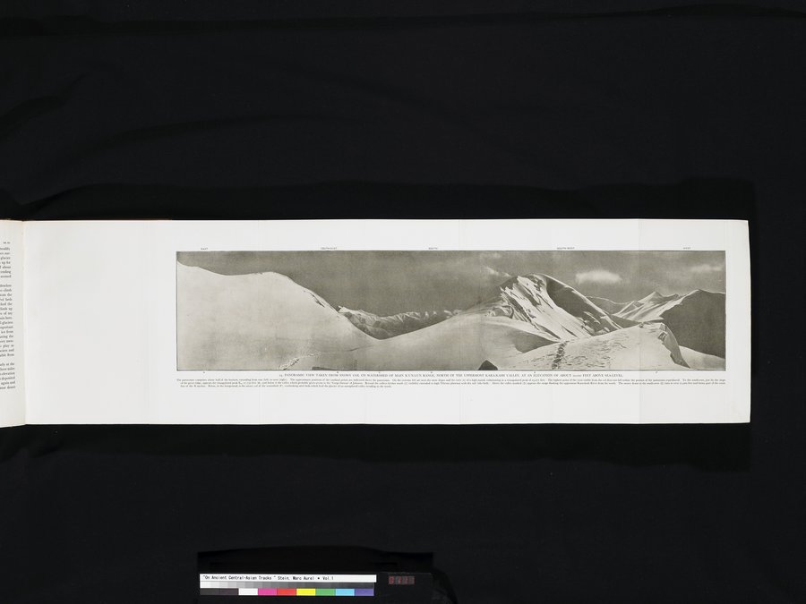
カラカシュ渓谷北部の,雪で覆われた崑崙山脈主部の分岐点にあたる鞍部から撮影した全景写真,高度は海抜約20,000フィート。この全景写真には地平線の約半分が写っており,東(左)から西(右)にのびている。基本方位のおおよその位置は全景写真の上部に表示している。左端には,雪の斜面と高い山塊の尾根(A)が見え,その末端は高度23,071フィートの三角形の頂上になっている。鞍部から見える頂上の最も高い部分はこの全景写真の枠外にある。南東方向には,まさに大きな峰の斜面のそばに,高度21,750フィート三角形をしたK1の頂上(B)が見えており,またその下方に,おそらくジョンソンの「ヤンギ・ダワン」に接近できる谷がある。その谷を越えてさらに南方(C)の視界は干上がった塩湖およびチベット高原にのびている。(D)のマークのある谷の上方には,南からカラカシュ河(黒玉河)最上流に隣接する山脈が見える。南西(E)方向の雪に覆われたドームは海抜21,100フィート以上あり,崑崙の頂上線の一部を形づくる。手前の下方にあるのは、分岐点にあたる雪で覆われた鞍部。また粒状氷雪の層を見下ろす。この粒状氷雪は北に向かう未踏の谷の氷河を形成する。PANORAMIC VIEW TAKEN FROM SNOWY COL ON WATERSHED OF MAIN K`UN-LUN RANGE, NORTH OF THE UPPERMOST KARA-KASH VALLEY, AT AN ELEVATION OF ABOUT 20,000 FEET ABOVE SEA-LEVEL. The panorama comprises about half of the horizon, extending from east (left) to west (right). The approximate positions of the cardinal points are indicated above the panorama. On the extreme left are seen the snow slopes and the crest (A) of a high massif,culminating in a triangulated peak of 23,071 feet. The highest point of the crest visible from the col does not fall within the portion of the panorama reproduced. To the south-east, just by the slope of the great ridge, appears the triangulated peak K1, 21,750 feet (B), and below it the valley which probably gives access to the ‘Yangi Dawan’ of Johnson. Beyond the valleys farther south (C) visibility extended to high Tibetan plateaux with dry salt lake-beds. Above the valley marked (D) appears the range flanking the uppermost Kara-kash River from the south. The snowy dome to the south-west (E) rises to over 21,100 feet and forms part of the crest-line of the K'un-lun. Below, in the foreground, is the snowy col of the watershed (F), overlooking névé beds which feed the glacier of an unexplored valley trending to the north.
|