国立情報学研究所 - ディジタル・シルクロード・プロジェクト
| |||||||||
|
| Serindia : vol.3 | |
| セリンディア : vol.3 |
 |
Sec. ii] THROUGH AK-SU AND UCH-TURFAN i3oi
north,24 to Ku-mo, or Ak-su, and to Wei-t`ou , 300 li westwards. The latter place is mentioned
by the Later Han Annals as on the road leading from Su-lé or Kashgar north-eastwards to Wên-su, Ku-mo, and Kuchä,25 and may be located with much probability about Akche on the upper Tushkandarya (Map No. 14. A. 2). This place is passed by the much-frequented summer route between Ak-su and Kashgar, and the adjoining area shows now a good deal of Kirghiz cultivation.26
SECTION III.—THROUGH THE MOUNTAINS TO KELPIN
The inquiries made during my stay at Uch-Turfan had failed to produce any information about old remains in the valley. But from villagers and Kirghiz alike I had heard vague stories about ruins of some mysterious town or castle, which was said to be sighted on clear days far away in the high mountains to the south, but to disappear whenever search for it was made. The statement that all those who had set out to seek the ruined town and to find its treasures had failed. to discover it was enough to suggest that these stories were but the local reflex of that Kölek-shahr, Sizahri-barbar, etc., which popular imagination is ever eagerly looking for in the desert near most oases round the Taklamakan. I was glad, all the same, when I found from what Akal-yolchi, an old hunter, told me that there would be a chance of following up this piece of local folk-lore on my way to Kelpin. Some ten years before, he with another Muhammadan had by the Amban's order accompanied a Chinaman, who was anxious to search for what he 'called ` the palace of. the Tang chief' and for some hidden inscription there, to the foot of certain peaks known as Kaka jcide and rising above the Kelpin route. The Chinaman after a three days' absence in the mountains had come back without revealing the result of his quest. Akal-yolchi himself had climbed up later on, but he had found nothing except rocky crags and a grassy plateau beyond the crest of the range.
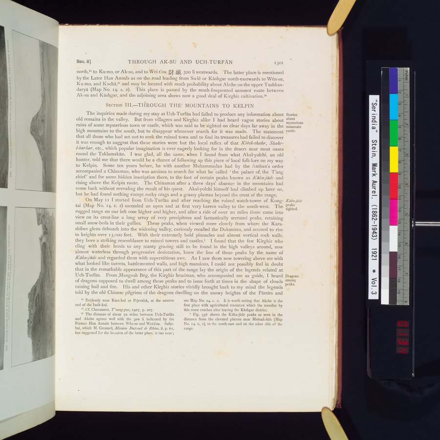
On May I I I started from Uch-Turfän and after reaching the ruined watch-tower of Kong-tai (Map No. 14. E. 2) ascended an open and at first very barren valley to the south-west. The rugged range on our left rose higher and higher, and after a ride of over 20 miles there came into view on its crest-line a long array of very precipitous and fantastically serrated peaks, retaining small snow-beds in their gullies. These peaks, when viewed more closely from where the Karashilwe glens debouch into the widening valley, curiously recalled the Dolomites, and seemed to rise to heights over 13,000 feet. With their extremely bold pinnacles and almost vertical rock walls, they bore a striking resemblance to ruined towers and castles.' I found that the few Kirghiz who cling with their herds to any scanty grazing still to be found in the high valleys around, now almost waterless through progressive desiccation, knew the line of these peaks by the name of Kdka jcide and regarded them with superstitious awe. As I saw them now towering above me with what looked like turrets, battlemented walls, and high mansions, I could not possibly feel in doubt that in the remarkable appearance of this part of the range lay the origin of the legends related at Uch-Turfân. From ,Mangush Beg, the Kirghiz headman, who accompanied me as guide, I heard of dragons supposed to dwell among these peaks and to issue forth at times in the shape of clouds raining hail and fire. His and other Kirghiz stories vividly brought back to my mind the legends told by the old Chinese pilgrims of the dragons dwelling on the snowy heights of the Pamirs and
Stories about mysterious mountain castle.
Kâka jade peaks sighted.
Dragons among peaks.
24 Evidently near Kara-kul or Prjevalsk, at the eastern end of the Issik-kul.
25 Cf. Chavannes, T `oung pao, 1907, p. 207.
26 The distance of about 7o miles between Uch-Turfân and Akche agrees well with the 300 li indicated by the Former Han Annals between Viên-su and Wei-fou. Safarbai, which M. Grenard, Mission Dulreuil de Rhins, ii. p. 6i, has suggested for the location of the latter place, is too near;
see Map No. 14. c. 2. It is worth noting that Akche is the first place with agricultural resources which the traveller by this route reaches after leaving the Kashgar district.
Fig. 336 shows the Kâka-jade peaks as seen in the distance from the elevated plateau near Moinak-kâk (Map No. 14. r., 2), to the south-east and on the other side of the range.
|
Copyright (C) 2003-2019
National Institute of Informatics(国立情報学研究所)
and
The Toyo Bunko(東洋文庫). All Rights Reserved.
本ウェブサイトに掲載するデジタル文化資源の無断転載は固くお断りいたします。