国立情報学研究所 - ディジタル・シルクロード・プロジェクト
| |||||||||
|
| Results of a Scientific Mission to India and High Asia : vol.5 | |
| インドおよび高地アジアへの科学調査隊派遣の成果 : vol.5 |
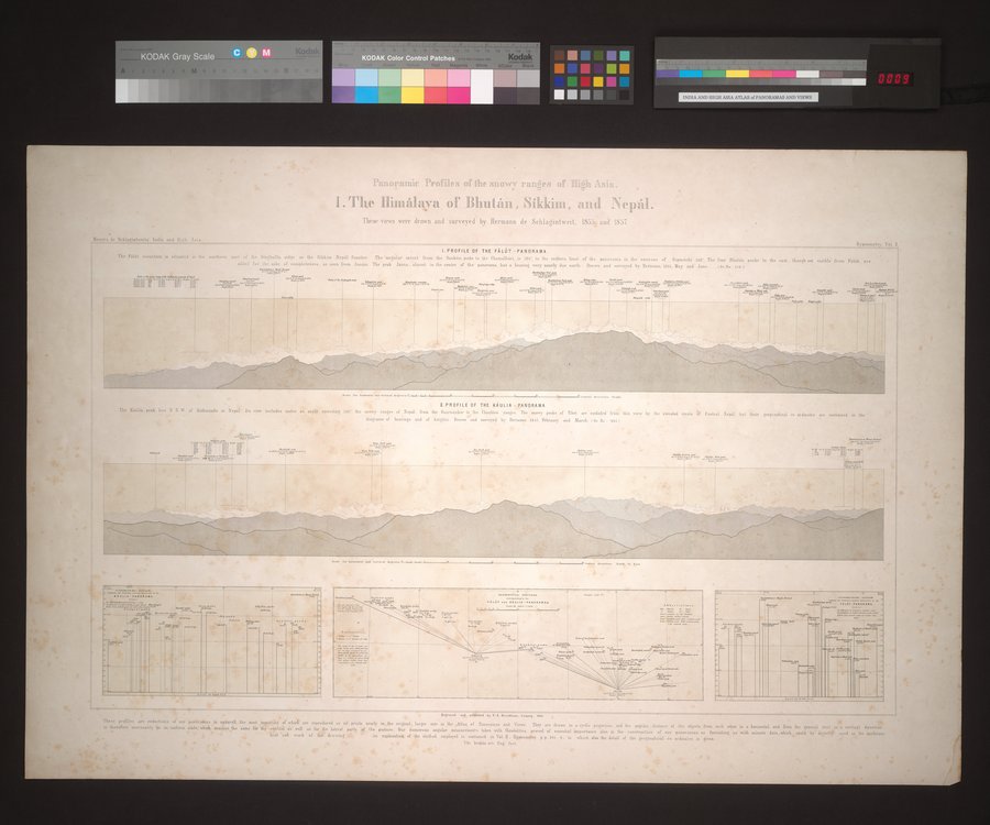 |
| 高地アジアの降雪地帯の外観図。 I. ヒマラヤとブータン、シッキム、そしてネパール。これらの眺望はヘルマン・ドゥ・シュラーギントヴァイトによって1855年から1857年にかけて素描・調査された。Panoramic Profiles of the snowy ranges of High Asia. I. The Himálaya of Bhután, Síkkim, and Nepál. These views ware drawn and surveyed by Hermann de Schlagintweit, 1855 and 1857. |
'L~ .. ~ •.
: ;►r.
, .w' ,~f=L71D11'HIIIlfl~C Profiles of the 9II1D`J~'~' l'ElI1~PS DlÎ ~Illl t'~S7El,
1IU.
I. The Ilinuilaya of Bhutân , Sikkim, and iNei ûl.
These views were drawn and surveyed by Hermann de Schlagintweit. 1855, and 1857
,` huts de Sehlalinlweiti. India and Iligh Asta.
I. PROFILE OF THE FÂLÛT -PANORAMA.
The Paldt mountain is situated in the northern port of the Singhallla ridge on the Sikkim •Sepil frontier The angular estent from the Sankdsi peaks to the Cbamalhdri is ¢5•. to the eastern limit or the panorama in the environs of Gtpmdchi in. The four Bhutan peaks to the rail. though not n front mm.: fro. arbearingadded for the nake of eompleten... as seen from Assam. The peak Jannu. almost in the rentre of the panorama. lus • bearing very nearly due north Brawn and surveyed by Hermann. toss. May und June. 1pr.Ne. aie t
aillareetar
B r ".'1'. ~<9 ,..,:r .... as rr wow. .. .btlitE.'7!J. ~ •• e.y~, ..fin. ~4 `W'>YxiYi^'.. --.2.-:'e44."'. .•'.r a• SYIY., .....: C , !•fx~td`
c ^'...h ,sir' s "J —+`d°°
~.+Yl••~ r ,,,,,,yy~;.
Y. PROFILE OF THE KliULIA • PANORAMA
The Kmoiia peak lie. N N w of Kathmandu in Nepal Its view includes under N anti,, exceeding Ise! the snowy ranger el Nepal from the Gaurisankar te the fhaubi.ù ranges The snowy peak. of Tibet an excluded front this view by the elevated
diagrams of beannga and of heights Drawn and surveyed by Ilermann. 1557 February and March On No ses
r — - l Ant ,..,s ..d ..Mabee y "A. ..AL., Legs:p. saw - -- - , - -- •--_ -
These profiles are redactions of our paubramas in atgear ell . the most w~,.el 4 of whir a reproduced a oil prints early m the ongin.l, lutes m the ,Atb o of Panoramas and Views. They are drawn tot projection, and the angular, distance of the objects. from each oatr m a honrontal. and from • the general lens • rnrtiwl dq.cu~
IA therefore necessarily tan an uniform seal,. whit oeouna the same fee dtpy opb i a well n. for the lateral parrs .f n the piston,. Our numerous use mess ante taken + with Ch aioliles. proved of that importance also m the onslrneüan of o panoramas. s famishing u with minute data. which sanld be' drçectl# card as the toothrm
1 Ord 'nil • work as Oat drawing 4 An explanation of the method employed is e ronlalned in Vol. H. Uyp.om,Ry pp. tat 5, in which also the detail of +the geographical no- ordinates is sgiven.
a• ? , . Th. hat . are Gag. feet
nati
t• X• «..
':.........
|
Copyright (C) 2003-2019
National Institute of Informatics(国立情報学研究所)
and
The Toyo Bunko(東洋文庫). All Rights Reserved.
本ウェブサイトに掲載するデジタル文化資源の無断転載は固くお断りいたします。