国立情報学研究所 - ディジタル・シルクロード・プロジェクト
| |||||||||
|
| Results of a Scientific Mission to India and High Asia : vol.5 | |
| インドおよび高地アジアへの科学調査隊派遣の成果 : vol.5 |
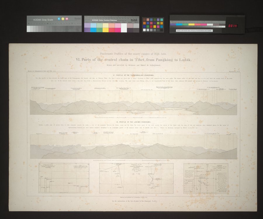 |
| 高地アジアの降雪地帯の外観図。 VI. チベット中央部の部分、Pangkóng からラダックまで。ヘルマンおよびロベール・ドゥ・シュラーギントヴァイトによって素描と調査が行われた。Panoramic Profiles of the snowy ranges of High Asia. VI. Parts of the central chain in Tibet, from Pangkóng to Ladák. Drawn and surveyed by Hermann and Robert de Schlagintweit. |
Messes, de Sehlagintwetts Ina., and Ilt4b A513
r
S••••••••• • • •
T
........... w.O.
sA•em• RR.
6•••••■■■•■■•
r•- sew ••• moms
T
'T • .00
! 9
6 • •
••••
so ••••• e • •
•
•
If vpsom ele y. Val 11
W..
RR, •■•■p(......
ft• ••
-•
s.
A. • .,
•
4 • Fen Profiles of Ole snow ranges of Bien Asia.
VI. Parts of the- central chain in Tibet ,from Pangkôlig to Ladâk. •
. Drawn and surveyed by Hermann and Robert de Sehlagintweit.
*
13. PROFILE OF THE TSOMOGNALARI-PANORAMA.
Per 04. profile we have selected the lowe,r port of the Tsomognolarl. the largest salt lake of Western Tibet The chief 1. serves ss • good type of minor elevations in Tibet with comparatively few snow peaks . The former outlet • of the /aim now dry, is to be sesn shove the present level of Um water,
also one of the lateral rivers shows a dry bed, they form a characteristic feature of the salt lake ...ell. The view taken near. sTikung, close to the considerable bead of the lower lake. embraces 250! Dracut and surveyed by Ifern.s 'eoN.. 363 6,33.
s•aft::.....17.••• 4.0 ...A...v=7
•••••,-,.'
0•••■•••••■■•• swag.
••••••••■•■•td.,/•11•••••
14. PROFILE OF THE LARIMO-PANORAMA.
Lirisso. o peak easy of acre., close to Leh. rostmaad. towards the south II view of the mountains between the Brisna ramie and the Indus The lower ports of the new include the shores of the Inds.. with the town of Lek and numerous other inhabited places. In this series of
representations. however. we have limited ourselve, throughout to the orographie profile of the mountain strains only. It extends over MS..— Drawn by Rertminn, surveyed by Robert t Oc Nog 367 5 36R
••••••••••
'
•••••, I•••■•••
1•• •••
Id=
43:P••••••
r,
Lograrel R3.1 yabb•164 by ? etnielham.leip'sig. 1661
Meter ..14.11,6
See the explanations at the foot of plate I of the .Panorrunie Profiles'. •
•
OR
•
••••••■;..;:n
|
Copyright (C) 2003-2019
National Institute of Informatics(国立情報学研究所)
and
The Toyo Bunko(東洋文庫). All Rights Reserved.
本ウェブサイトに掲載するデジタル文化資源の無断転載は固くお断りいたします。