国立情報学研究所 - ディジタル・シルクロード・プロジェクト
| |||||||||
|
| Results of a Scientific Mission to India and High Asia : vol.5 | |
| インドおよび高地アジアへの科学調査隊派遣の成果 : vol.5 |
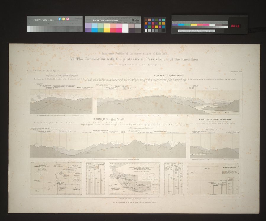 |
| 高地アジアの降雪地帯の外観図。VII. カラコルム、トルキスタンの高原および崑崙をともなう。 ヘルマンおよびロベール・ドゥ・シュラーギントヴァイトによって素描と調査が行われた。Panoramic Profiles of the snowy ranges of High Asia. VII. The Karakorúm, with the plateaux in Turkistán, and the Kuenlùen. Drawn and surveyed by Hermann and Robert de Schlagintweit. |
D•1norElnn]; IPtrofles 'tho snowy r)uises m!' 1jith
1~LThe Karakorilm,with the plateaux in Turkislian, nnd the Kuenliien.
Drawn and surveyed by Hermann and Robert de Sthlagintweil.
IN. PROFILE OF THE DAPSANO-PANORAMA. 16. PROFILE OF THE AKTAGH-PANORAMA.
Drava mail surveyed by Hermann tor. No 37oî Brawn and surveyed by Ilernienn.lac. No 371,
The Dipaaag and the »184k profiles combined include the principal objects to the north and south of the Karakordm erect_rasi deserted plateaux !probably the most elevated of our globe' and snowy peaks of unexpected height. Ar the principal peaks we mention the the latter I187T6 Itt being the second in height as yet known of all the peaks of Bith Asia. The total area of both profiles combined exceeds 410°
The Sdmgal and Yurungkish profiles
18. PROFILE OF THE YURUNOKi1SH -PANORAMA.
Drawn and annoyed by Bormann. la Ro*a711
1T. PROFILE OF THE SUMGAL - PANORAMA.
Drawn by'Ilrrmann, surveyed by hobo Se .ev.
enpeerrn outline of the Kneelrien Though the number of peaks comprised w Imsited by the short distance of the southern foot of the Kuenlden from ils crest, yet the general ehar.der of the prig
ridge is apparent. We could not. however. find upon il a peak excerdtnd :8000 ft. The Sr mdal panorama include, Dearly 9" of the entire horizon, 190"
AAAAA V••
WO(111/1,11041. 1.114710•16 Or T. meow..
Sec the explanations al the rod of plate I â the -Panoramic Profiles-
|
Copyright (C) 2003-2019
National Institute of Informatics(国立情報学研究所)
and
The Toyo Bunko(東洋文庫). All Rights Reserved.
本ウェブサイトに掲載するデジタル文化資源の無断転載は固くお断りいたします。