国立情報学研究所 - ディジタル・シルクロード・プロジェクト
| |||||||||
|
| Results of a Scientific Mission to India and High Asia : vol.6 | |
| インドおよび高地アジアへの科学調査隊派遣の成果 : vol.6 |
 |
CI
sA, , •
,„
OF A SC IENT 1 F IC 11 1S101\ 1 ()
N A. • ..±1-'N'--1) HIGH
r
x •
•
is
RY
HERMANN, ADOLPHE, AN]) ROBERT DE SCHLIGINTWEIT,
•
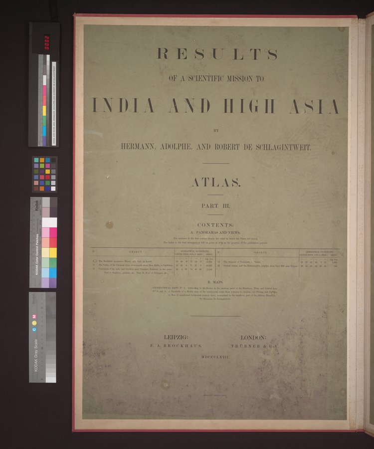
ATLAS.
a
•
PART III.
CONTENTS:.
A. PANORAMAS AND VIEWS.
The nutubers in the first column denote the order in which the Plates are issued.
The Index to the final arrangement will be given as crin as the progress of the publication permits.
| GEOGRAPHICAL CO-ORDINATIX N° LATITUDE EMIL corn E. OWL HEIGHT. | OBJECT. |
1,11.1En I.
•
•
. A
ii•-•!•
!!
tan
GEOGRAPHICAL 00-03DINA
LATITUDE NORTE. LONG. L '4111Gif.
•
33 59 0
35 49 0
31 4 36
77 16 0
77 81 0
74 48 30
o • .1 • • F.1
23 57 48 I 86 6 54 4,469
26 34 36 92 46 48 199
i The Buddhist monastery Hines, ova. Leh, in Leda
17 The Valley of the Ytirkand river, downwards from Dire Bello, in Turkistan
18 Panorama of the Lake and Gardens near Srinagar. Kashmir, in two parts:
Part In Shalimar gardens, six, Part I/: Fort of Srinagar,
' •
Eng. Feet.
12,324 19 The Summit of Parisnith, hailer
1083 20. Central Assam and the Braluttapetra juorles, from Ogrl Hill near Texpur
5,146 I
B. MAPS.
GEOGRAPHICAL MAPS: N° 2. Index-Map 6, the Routes in the western parts of the Himalaya, Tibet, and Central Agia.
N. 3 and 4. u) Vacs' le of a Rhetia map of the commercial route from Lhassa to Assam, rid Tdvang and Narlen.
h) Map of equidistant horizontal contour lines, determined in the southern part of the Sikkim Ilinuilsyn.
By Hermann de Schlagintweit.
an
'-.` • '-fitt••
t"
bitp c
44 .1.,
.4 • •
LEIPZIG: LONDON: 4 s •
. •
•
1 ".
h A,
* * ; • •
••.;•
' 4
N. •
-
•
F. A. B It 0 C K II A U s. TROBNER
•
1,7,,,• ;0
NEDCCCLXIII. s*;4''
•
|
Copyright (C) 2003-2019
National Institute of Informatics(国立情報学研究所)
and
The Toyo Bunko(東洋文庫). All Rights Reserved.
本ウェブサイトに掲載するデジタル文化資源の無断転載は固くお断りいたします。