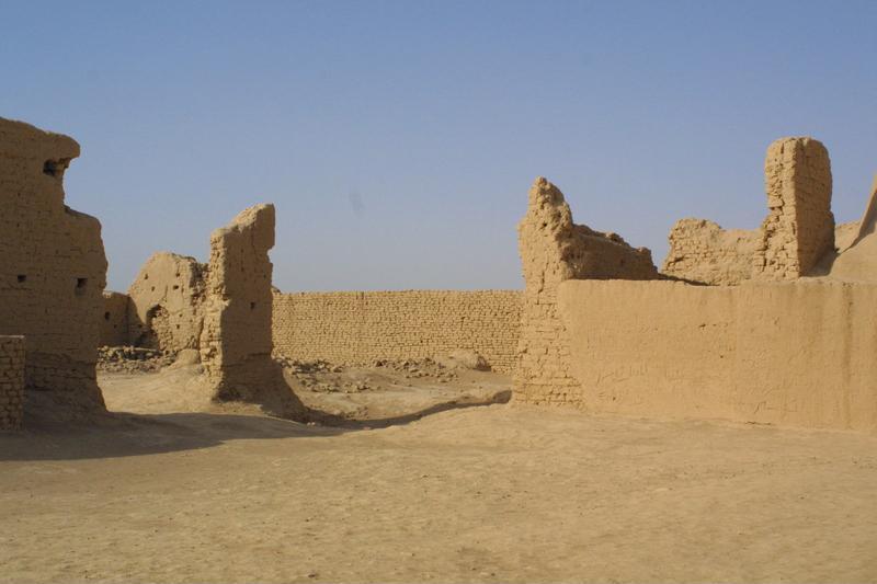
寺院址。高昌国は古代シルクロードの玄関口であり、火焔山近く、トルファンの南西40Kmに位置している。前漢時代には高昌壁といったような砦が築かれ、後代には政治・経済・文化面での中心となっていった。唐時代には、天竺取教途中に立ち寄った玄奘三蔵が国王麹文泰に請われて一ヶ月に渡る説法を行っている。国王ni仏教の信心が篤く、故城内にはいくつもの寺院址が見られる。遺跡は外城、内城、宮城の三つの部分から構成されており、城壁などがよく保存されている。 / Temple ruins. / Gaochen Kingdom was an important gateway on the ancient Silk Road, situated near the Flaming mountains 40 km southwest of Turfan. In the first century, military units of the eastern Han Dynasty doing farm work there established a rampart called Gaochangbi. Later it developed into a political, economic and cultural center along with historical changes. The monk XuanZang (602-664) of the Tang Dynasty preached in the city for the King of Gaochang during his pilgrimage to India for Buddhists scriptures. The ancient city of Gaochang consists of three parts: the outer city, the inner city and the palace city. The city walls are fairly well preserved and some other remains can still be seen.
カード情報
クラス
画像カード
資源識別子/Identifier (dcterms:identifier)
http://dsr.nii.ac.jp/photograph/iiif/gaochang0007.tif/full/full/0/default.jpg
空間的範囲/Spatial Coverage (dcterms:spatial)
高昌故城
地名カード
部分である/Is Part Of (dcterms:isPartOf)
http://dsr.nii.ac.jp/photograph/manifest/gaochang0007
番号/number (bibo:number)
http://dsr.nii.ac.jp/photograph/iiif/canvas/gaochang0007
ソース (dcterms:source)
画像
地図
- スタイン地名 - Innermost Asia / Kara-Khoja
- 未照合
- ヘディン地名 - Central Asia Atlas
- 照合済み
- ドイツ隊地名 - Idikutschari
- 未照合(画像カードあり)
- 黄文弼地名 - 塔里木盆地考古記 / 吐魯番考古記
- 照合済み(画像カードあり)
- DSR地名 - 写真でつなぐシルクロード
- 遺跡カード
リンク元カード
プロパティでフィルター
| タイトル | 代替ラベル | クラス |
|---|---|---|
| Canvas Indexer search result | キュレーションカード |
関連カードグラフ
遺跡カード
画像カード
画像照合カード
地名カード
地名照合カード
文献カード
キュレーションカード