National Institute of Informatics - Digital Silk Road Project
| |||||||||
|
| Explorations in Turkestan 1903 : vol.1 |
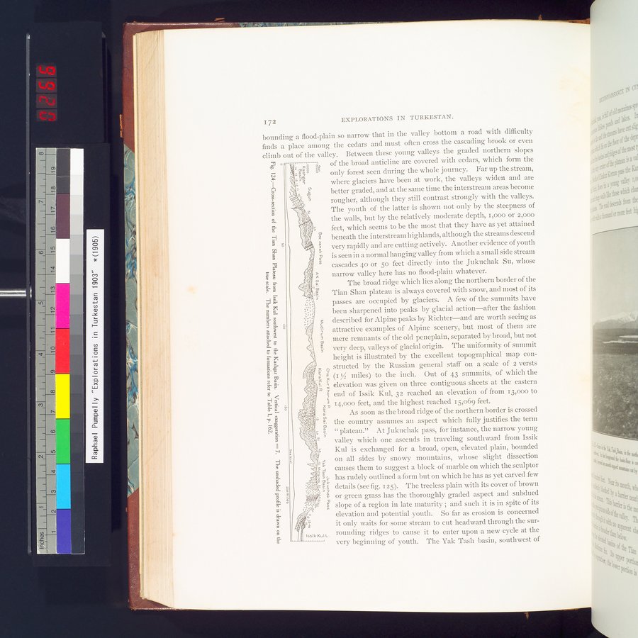 |
| Cross-section of the Tian Shan Plateau from Issik Kul southwest to the Kashgar Basin. Vertical exaggeration= 7. The unshaded profile is drawn on the true scale. The numbers attached to formations refer to Table I, p. 162. |
~ 72 EXPLORATIONS IN TURKESTAN.
bounding a flood-plain so narrow that in the valley bottom a road with difficulty finds a place among the cedars and must often cross the cascading brook or even climb out of the valley. Between these young valleys the graded northern slopes
°c ,. : xo N, of the broad anticline are covered with cedars, which form the
N ,- â Tg .. only forest seen during the whole journey. Far up the stream,
-51
-, here glaciers have been at work, the valleys widen and are
0 - s better graded, and at the same time the interstream areas become
x ' rougher, although they still contrast strongly with the valleys.
~
5. The youth of the latter is shown not only by the steepness of
0 ,'l ; the walls, but by the relatively moderate depth, i,000 or 2,000
' feet, which seems to be the most that they have as yet attained
5- Y Y
~~ beneath the interstream highlands, although the streams descend
w
g' very rapidly and are cutting actively. Another evidence of youth
m is seen in a normal hanging valley from which a small side stream
I. o cascades 4o or 5o feet directly into the Jukuchak Su, whose
0.
c narrow valley here has no flood-plain whatever.
The broad ridge which lies along the northern border of the
Fr § l % 'N W
H Tian Shan plateau is always covered with snow, and most of its
'
passes are occupied by glaciers. A few of the summits have
been sharpened into peaks by glacial action—after the fashion
c 3 described for Alpine peaks by Richter—and are worth seeing as
a ` r a attractive examples of Alpine scenery, but most of them are
-â mere remnants of the old peneplain, separated by broad, but not
s very deep, valleys of glacial origin. The uniformity of summit
d height is illustrated by the excellent topographical map con-
w ; ...structed by the Russian general staff on a scale of 2 versts
~, ; (/f â z (1 IZ miles) to the inch. Out of 43 summits, of which the
s•>!A, c , elevation was given on three contiguous sheets at the eastern eÇ: A s
Ó~ t'., g end of Issik Kul, 32 reached an elevation of from 13,000 to
~. f`; ' â , 14,000 feet, and the highest reached 15,069 feet.•
_> a As soon as the broad ridge of the northern border is crossed
t;~, W the country assumes an aspect which fully justifies the term
N Â , t4 plateau." At Jukuchak pass, for instance, the narrow young
?c.. valley which one ascends in traveling southward from Issik
II
i; Kul is exchanged for a broad, open, elevated plain, bounded
.-.1 _
7. 11{ on all sides by snowy mountains, whose slight dissection
$` ; F. causes them to suggest a block of marble on which the sculptor
co .. _ L has rudely outlined a form but on which he has as et carved few
WC Y Y
"s I ;"s details (see fig. 125). The treeless plain with its cover of brown
N
11 or green grass has the thoroughly graded aspect and subdued
" = N slope of a region in late maturity ; and such it is in spite of its
Li- „'. ti elevation and potential youth. So far as erosion is concerned
a r'r_ a
:~..N;, it only waits for some stream to cut headward through the sur-
I66ik Kul L. rounding ridges to cause it to enter upon a new cycle at the
ç very beginning of youth. The Yak Tash basin, southwest of
LI!
|
Copyright (C) 2003-2019 National Institute of Informatics and The Toyo Bunko. All Rights Reserved.