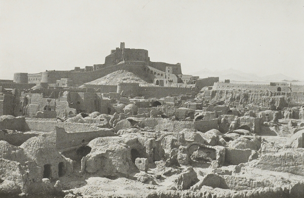
イラン・バムの城塞
| |||||
|
この写真は、オーレル・スタインがおよそ70年ほど前に、北西インドと南東イランにおける考古学的探険の途中で撮影したものである(参照)。
この写真は、バム城塞を取り囲む南側の城壁から、北および北西方向を眺望しており、統治者地域と、2番目、3番目、4番目の防御壁が写っている。また写真の左側には、城塞の最高地点である望楼と、遠くには行政区画の第二門が見えている。
スタインがバムの城塞を探険した時の記述に以下のような一節がある。
More interesting was a visit to large Arq of Bam. Once considered as the strongest fortress of Persia. Since its abandonment in the last century it is slowly crumbling to ruins. (テキスト)
このスタインの記述によると、城塞はガージャール朝(1795-1925)の19世紀末あるいはもう少し後の頃には放棄されたようである。写真からもわかるように、城塞はすでにこの時期でもかなり大規模に崩れはじめている。これが地震等の自然災害に起因するのか、それとも人間の破壊活動に起因するのかは、今後の調査が待たれる。
Copyright (C) 2004-2015 National Institute of Informatics and the Owner of the Data.
このウェブサイトは、アンダルーディ・エルハム、北本 朝展、およびディジタル・シルクロード・チームが管理しています。