| [Figure] |
粛州
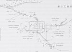
粛州。壁は高さ7-8尋で焼きレンガで出来ており、銃眼付き胸壁があり、たくさんの壁の突出部があり、そのうち門を保護するもののみ様々な大きさで出来ている。外側の防御区域は無い。堀は実際には埋められている。東の角の突出部にのみ小さな塔がある。門の上は12ヤード、門の突出部は奥行きが20ヤード、そして内門は40ヤードある。門の近くの北や南には小さな家屋の集まりがあって、東のほうには高さ3 1/2-4尋の泥土か日干しレンガで出来た手入れされていない壁で囲まれたかなり大きな郊外がある。壁の内側の区域は、通りがとても規則的に走っている。最西端部分は一部は人が居住しておらず、一部は大きな寺院の建物で占められている。道台と鎮台の衙門は、南東の角にあって、Tsouguanの衙門は街の北部の中央にある。- 西・南・南南西の土地は様々な平地に耕作された畑から成っており、数多くの小さな水路が走り、樹木や家屋が点在している。家屋は西に最も多く、地面はわずかに高い。北では地面はほとんど完全に開けている。砂利で覆われていて幅は2/3マイルある北大河の河床はそこにあり、地面はそのほうへとごくわずかに傾斜している。河床の北では、地面はわずかに上り坂になり、所々で急な傾斜を作っている。東・南東では、地面はまたとても開けていて低い。南では、地面はわずかに上り坂になっている。峡谷のような勾配は、高さが最大2尋あり、西・南・東の要塞のすぐそばまで走っている。西と一部東のの道路は地面の中に深く沈んでいる。筆者による作図。SUCHOW
Suchow. Wall 7-8 fathoms high of baked bricks with a crenellated parapet and many wall projections, of which only those protecting the gates are of any size. No outer protected space. Fosse practically filled up. Small towers only on the E corner projections. Over gate 12 yds, gate projection in depth 20 yds and inner gate 40 yds. Small groups of houses in the N and S near the gates; in the E a fairly large suburb surrounded by a neglected wall of clay or unbaked bricks, 3 1/2-4 fathoms high. The space inside the wall fairly regularly intersected by streets. The westernmost part is partly uninhabited, partly occupied by large temple buildings. The yamens of the Djentai and Taotai are in the SE corner, the Tsouguan's in the centre of the N part of the town. - The land in the W, S and SSE consists of tilled fields at various levels, intersected by a great many small ariqs and strewn with thin trees and scattered houses. The houses are most numerous in the W and the ground is slightly higher, in the N it is practically entirely open. The bed of the Pei-ta-ho, covered with gravel and 2/3 of a mile wide, lies there and the ground slopes towards it almost imperceptibly. N of the river bed it rises slightly and forms a steep incline in some places. In the E and SE the ground is also very open and low, in the S it rises very slightly. A ravine-like incline, up to 2 fathoms in height, runs close to the fortress in the W, S and E. The roads in the W and partly in the E are deeply sunken in the ground. - Drawn by the author.
|

