National Institute of Informatics - Digital Silk Road Project
| |||||||||
|
| Explorations in Turkestan : Expedition of 1904 : vol.1 |
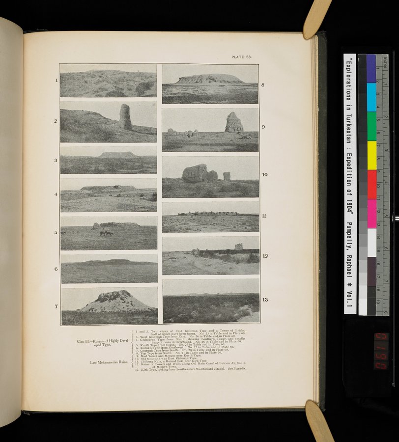 |
| Class III.-Kurgans of Highly Developed Type. Two views of East Kishman Tepe and a Tower of Bricks, half of which have been burnt. No. 23 in Table and in Plate 60. | |
| Class III.-Kurgans of Highly Developed Type. West Kishman Tepe from East. No. 24 in Table and in Plate 60. | |
| Class III.-Kurgans of Highly Developed Type. Gechekran Tepe from South, showing Southern Tower, and smaller heap pf ruins in foreground. No. 26 in Table and in Plate 60. | |
| Class III.-Kurgans of Highly Developed Type. Kurtili Tepe from South. No. 27 in Table and in Plate 60. | |
| Class III.-Kurgans of Highly Developed Type. Kurukli Tepe from Northwest. No. 22 in Table and in Plate 60. | |
| Class III.-Kurgans of Highly Developed Type. Churnuk Tepe from South. No. 28 in Table and in Plate 60. | |
| Class III.-Kurgans of Highly Developed Type. Top Tepe from South. No. 21 in Table and in Plate 60. | |
| Late Mohammedan Ruins. Mud Tower and Mosque near Kurtli Tepe. | |
| Late Mohammedan Ruins. Old Mosque (?) at East Kishman Tepe. | |
| Late Mohammedan Ruins. Chilburg Kala, a Ruined Fort near Kirk Tepe. | |
| Late Mohammedan Ruins. Ruins of Towers and Walls along Old Main Canal of Bairam Ali, South of Modern Town. | |
| Kirk Tepe, looking from Southeastern Wall toward Citadel. See Plate 60. |
PLATE 58.
1
1 and 2. Two views of East Kishman Tepe and a Tower of Bricks, half of which have been burnt. No. 23 in Table and in Plate 60. 3. West Kishman Tepe from East. No. 24 in Table and in Plate 60.
Class III.—Kurgans of Highly Devel- 4. Gechekran Tepe from South, showing Southern Tower, and smaller
heap of ruins in foreground. No. 26 in Table and in Plate 60.
oped Type. 5. Kurtli Tepe from South. No. 27 in Table and in Plate 60.
6. Kurukli Tepe from Northwest. No. 22 in Table and in Plate 60. ' 7. Churnuk Tepe from South. No. 28 in Table and in Plate 60.
Top Tepe from South. No. 21 in Table and in Plate 60.
Mud Tower and Mosque near Kurtli Tepe.
' 10. Old Mosque (?) at East Kishman Tepe.
Late Mohammedan Ruins. j 11. Chilburg Kala, a Ruined Fort near Kirk Tepe.
112. Ruins of Towers and Walls along Old Main Canal of Bairam Ali, South
of Modern Town.
13. Kirk Tepe, looking from Southeastern Wall toward Citadel. See Plate 60.
|
Copyright (C) 2003-2019 National Institute of Informatics and The Toyo Bunko. All Rights Reserved.