国立情報学研究所 - ディジタル・シルクロード・プロジェクト
| |||||||||
|
| Explorations in Turkestan : Expedition of 1904 : vol.2 | |
| トルキスタンの調査 1904年 : vol.2 |
 |
| ゼラフシャン渓谷にある氷河に圧迫された沖積層の断面 氷河の45マイル下Section of Glacier-thrusted Alluvium in the Zerafshan Valley, 45 Miles below the Glacier. |
DESERTS.
279
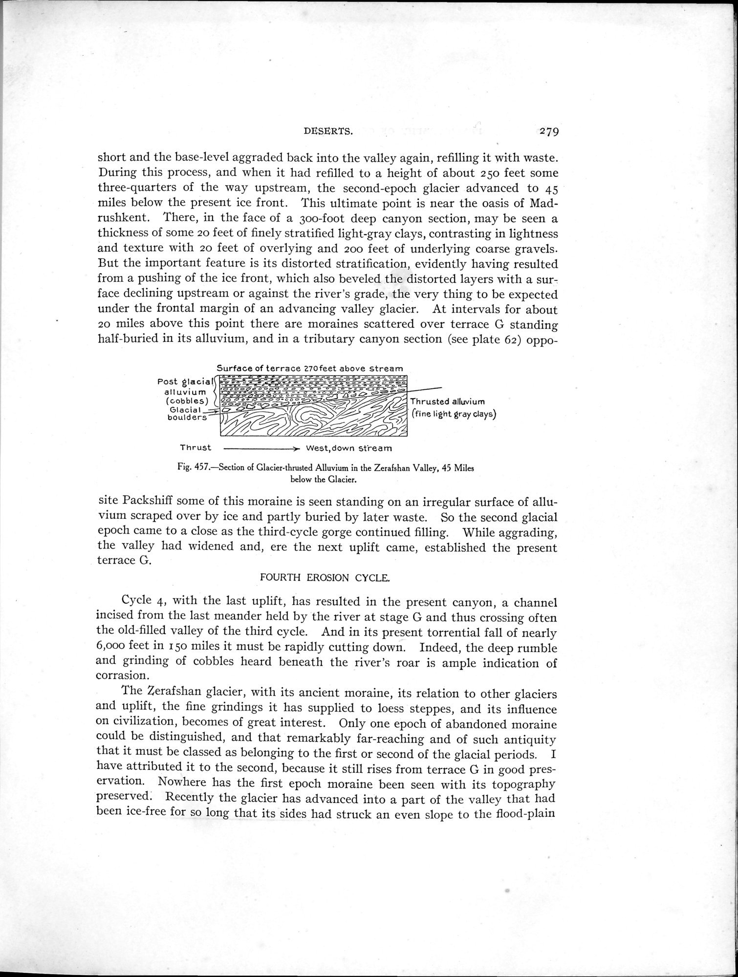
short and the base-level aggraded back into the valley again, refilling it with waste. During this process, and when it had refilled to a height of about 25o feet some three-quarters of the way upstream, the second-epoch glacier advanced to 45 miles below the present ice front. This ultimate point is near the oasis of Madrushkent. There, in the face of a Soo-foot deep canyon section, may be seen a thickness of some zo feet of finely stratified light-gray clays, contrasting in lightness and texture with zo feet of overlying and 200 feet of underlying coarse gravels. But the important feature is its distorted stratification, evidently having resulted from a pushing of the ice front, which also beveled the distorted layers with a surface declining upstream or against the river's grade, the very thing to be expected under the frontal margin of an advancing valley glacier. At intervals for about 20 miles above this point there are moraines scattered over terrace G standing half-buried in its alluvium, and in a tributary canyon section (see plate 62) oppo-
Surface of terrace 270feet above stream
Post glacial
alluvium
(cobbles)
Glacial_ ..
boulders
°- .~'~ r •—"sg— ~~~~
_ . oo, -~ _
_s. _~_ é ~aä ~ 4•.iT--'..`~ â 0 oa~
ss~ `~ ~ ~ Thrusted alluvium
° (fine light gray clays)
° a • ä==~ ve
Thrust West,down stream
Fig. 457.—Section of Glacier-thrusted Alluvium in the Zerafshan Valley, 45 Miles
below the Glacier.
site Packshiff some of this moraine is seen standing on an irregular surface of alluvium scraped over by ice and partly buried by later waste. So the second glacial epoch came to a close as the third-cycle gorge continued filling. While aggrading, the valley had widened and, ere the next uplift came, established the present terrace G.
FOURTH EROSION CYCLE.
Cycle 4, with the last uplift, has resulted in the present canyon, a channel incised from the last meander held by the river at stage G and thus crossing often the old-filled valley of the third cycle. And in its present torrential fall of nearly 6,000 feet in 15o miles it must be rapidly cutting down. Indeed, the deep rumble and grinding of cobbles heard beneath the river's roar is ample indication of corrasion.
The Zerafshan glacier, with its ancient moraine, its relation to other glaciers and uplift, the fine grindings it has supplied to loess steppes, and its influence on civilization, becomes of great interest. Only one epoch of abandoned moraine could be distinguished, and that remarkably far-reaching and of such antiquity that it must be classed as belonging to the first or second of the glacial periods. I have attributed it to the second, because it still rises from terrace G in good preservation. Nowhere has the first epoch moraine been seen with its topography preserved. Recently the glacier has advanced into a part of the valley that had been ice-free for so long that its sides had struck an even slope to the flood-plain
|
Copyright (C) 2003-2019
National Institute of Informatics(国立情報学研究所)
and
The Toyo Bunko(東洋文庫). All Rights Reserved.
本ウェブサイトに掲載するデジタル文化資源の無断転載は固くお断りいたします。