国立情報学研究所 - ディジタル・シルクロード・プロジェクト
| |||||||||
|
| On Ancient Central-Asian Tracks : vol.1 | |
| 中央アジア踏査記 : vol.1 |
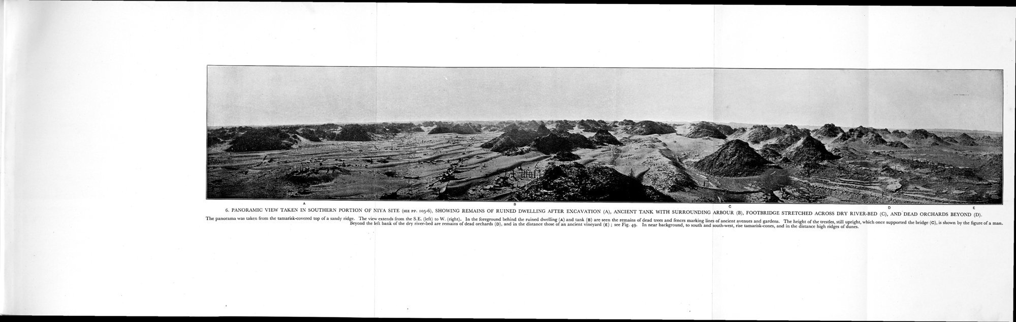 |
| ニヤ遺跡南部(105-6頁参照)で撮影した全景,発掘後の住宅の遺跡(A),古代の貯蔵槽と周囲のあずまや(B),干上がった川床の向こう側まで伸ばされた歩道橋 (C),そして向こうに荒れた果樹園が見える。この全景写真はタマリスクで覆われた砂山の頂上から撮影したもの。南東(左)から西(右)に広がる眺め。手前には,住宅跡(A)と貯蔵槽(B)の後方に古代の通りと庭との境界線を示す枯れ木と柵の残骸が見える。かつて橋を支えていた橋脚(C)は今なおまっすぐ立っており,その高さは男性の姿を指標に知ることができる。干上がった川床の左岸の向こうに荒れた果樹園跡(D)があり,さらにその遠方に古代のブドウ園跡(E)がある(図49参照)。近い背景では,円錐形に盛り上がったタマリスクがあり、その遠方に高い砂丘の尾根が見える。PANORAMIC VIEW TAKEN IN SOUTHERN PORTION OF NIYA SITE (SEE PP. 105-6), SHOWING REMAINDS OF RUINED DWELLING AFTER EXCAVATION (A), ANCIENT TANK WITH SURROUNDING ARBOUR (B), FOOTBRIDGE STRETCHED ACOSS DRY RIVER-BED (C), AND DEAD ORCHARDS BEYOND (D). The panorama was taken from the tamarisk-covered top of a sandy ridge. The view extends from the S. E. (left) to W. (right). In the foreground behind the ruined dwelling (A) and tank (B) are seen the remains of dead trees and fences marking lines of ancient avenues and gardens. The height of the trestles, still upright, which once supported the bridge (C), is shown by the figure of a man. Beyond the left bank of the dry river-bed are remains of dead orchards (D), and in the distance those of an ancient vineyard (E); see Fig. 49. In near background, to south and south-west, rise tamarisk-cones, and in the distance high ridges of dunes. |
y. l':\\VR:\\IIC: N'lI.)\"L\Rb.N IN SOCTHERN PORTION OF NITA SITE (,EE re. toy.6). SHOWING REMAINS OF RUINED I)Wb.b.I.IM; .\I ILK EXCAVATION (A). ANCIENT TANK WITH SURROUNDING ARBOUR (B), FOOTBRIDGE. STRETCHED ACROSS DRY RIVERBED ,c:), AND DLAI) ()RLII.\RI)S HEWN!) (I)).
The panoean o was taken lions the tamarisk-covered top of a sandy ridge. 'Ile view extends from the S.E. (left) to W. (right). In the horDgeDund behind the ruined dwelling (a) and tank (e) are seen the remains of dead ,rem and fences marking lines of anniint avenues and gardens. Tho height of the tresrlcs.,ill upright, which once supported the bridge (C), is shown by the figure of a man. Beyond the left bank of the dry rioenbed are remains of dead orchards (I)). and in the distance thou of an ancient vineyard (E) ; ses Fig. 49. In near background, to south and ,wth.weat, rie tamarisk-cones. and in the distance high ridges of dune,.
|
Copyright (C) 2003-2019
National Institute of Informatics(国立情報学研究所)
and
The Toyo Bunko(東洋文庫). All Rights Reserved.
本ウェブサイトに掲載するデジタル文化資源の無断転載は固くお断りいたします。