| [Photo] X. |
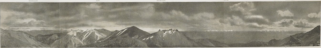
フオニントー峠上方の分水嶺の頂上から撮られたパノラマ写真.リヒトフォーフェン・托来山・アレクサンダーIII.の各山脈の一部が見える.このパノラマ写真は峠の北西、標高15、500フィート地点から撮られた.峠自体は岩の多い前景に隠れている(D; ii、 pp. 314以下と地図III参照).この景色は北東(左)から南西(右)に広がる.パノラマ上部の見出しは近い方角を表す.フンシュイパ河の西(A)と東(B)にある18、000フィート以上の高さの峰がそびえるリヒトフォーフェン山脈の一部である.峠が続いている托来山山脈の高い峰は、隣の尾根(C)に隠されている.北大河の幅広の渓谷を越えて、遠くにおよそ19、000フィートの高さであるウゲ山連峰(E)が見えている.そして、それ以外の雪をかぶったアレクサンダーIII.山脈の一部が見えている.我々がこの山脈を越えてきた峠の近接地は(G)で示されている.同じ地点の北西側の景色に関しては、図版237参照.PANORAMIC VIEW TAKEN FROM CREST OF WATERSHED ABOVE HUO-NING-TO PASS, SHOWING PORTIONS OF THE RICHTHOFEN, TO-LAI-SHAN AND ALEXANDER III RANGES OF NAN-SHAN. The panorama was taken at an elevation of circ. 15,500 feet to the north-west of the pass, which itself is hidden by rocky foreground (D; see ii pp. 314 sqq. and Map III.). The view extends from north-east (left) to south-west (right); the entries above the panorama indicate only the approximate bearings. It shows portions of the Richthofen Range west (A) and east (B) of Hung-shui-pa Ho, rising to peaks of over 18,000 feet. The high peaks of the To-lai-shan Range, over which the pass leads, are masked by neighbouring ridges (C). Across the wide valley of the Pei-ta Ho are seen in the distance the Uge-shan group (E), rising to close on 19,000 feet, and other snowy portions of the Alexander III. Range (F to H). The approximate position of the pass by which we crossed this renge is indicated by (G). For a view from the same point to the north-west see Fig. 237.
|