| [Photo] XII |
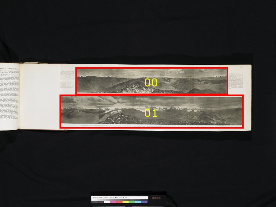
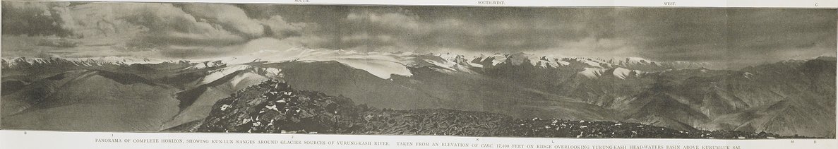
全水平方向のパノラマ.ユルンカシュ河の源流の氷河に囲まれたクンルン山脈が見える.クルムルク上方のユルンカシュ河源の水たまりを見下ろす標高約17、400フィートの尾根の上から撮影.PANORAMA OF COMPLETE HORIZON, SHOWING KUN-LUN RANGES AROUND GLACIER SOURCES OF YURUNG-KASH RIVER. TAKEN FROM AN ELEVATION OF CIRC. 17,400 FEET ON RIDGE OVERLOOKING YURUNG-KASH HEAD-WATERS BASIN ABOVE KURUMLUK SAI.
|
| [Photo] XII.〜t |
パノラマの上部部分は、北西(左)から東(右)まで広がっている.下部部分は、南東(左)から西(右)まで広がっている.全体的な特徴に関しての簡単な記述として、ii. pp. 454以下を参照.それぞれのパノラマ写真の上部に付いている見出しは、ただ大体の方向を示しているだけである.A、 B、 C、 Dは下部パノラマが上部パノラマと重なっている線を示す.その後には、景色は、ユルンカシュ河源とセギズキョル池を分かつ雪を頂いた連峰から、ケリヤとニヤ(F)上方の北クンルン系の遠い峰々まで、そして最も高いユルンカシュの流れ(G)とギュ=グルギュ氷河(H)まで連なる.The upper portion of the panorama extends from north-west (left) to east (right); the lower portion from south-east (left) to west (right). For a brief description of the general features see ii. pp. 454 sqq. The entries above each portion of the panorama indicate only approximate bearings. A B, C D mark the lines where the lower portion overlaps the upper one. In the latter the view ranges from the snowy massif (E), dividing the Yurung-kash head-waters and the Seghiz-köl basin, to the distant peaks of the Northern Kun-lun chain above Keriya and Niya (F), and to the uppermost Yurung-kash course (G) and the Gügrüge Glacier (H).
|
| [Photo] XII.〜b |
下部には連続して、22、000フィート以上の高さにそびえ、ユルンカシュとケリヤ河の源流を分かつ氷を頂いた山脈(I)や、クンルン山脈主峰を覆い、ユルンカシュに最も東方の源流を提供している巨大な氷の表層(J)や、ライテン湖とユルンカシュ河の間の高地にある分水嶺から流れ出す、トゥサイや他の大規模な流氷(K)が見える.後者の深く切り立った渓谷(L; ii. pp. 451以下参照)と我々の三角測量台のあるタルコル山脚(M; ii. p. 450参照).In the lower portion are seen successively the ice-crowned range (l), rising to heights of over 22,000 feet, which separates the Yurung-kash and Keriya River sources; the great ice mantle (J) which covers the main Kun-lun range south and feeds the easternmost head-waters of the Yurung-kash; the Tu-sai and other great ice-streams (K) descending from the high watershed between Lake Lighten and the Yurung-kash River; the deep-cut gorge of the latter (L; see ii. pp. 451 sqq.); and the Tar-kol spur (M; see ii. p. 450) with our triangulation station.
|