National Institute of Informatics - Digital Silk Road Project
| |||||||||
|
| Scientific Results of a Journey in Central Asia, 1899-1902 : vol.1 |
 |
| Usun-Jurt, October 22. |
THE KODAJ-DARJA AND THE KASCHGAR-DARJA. 63
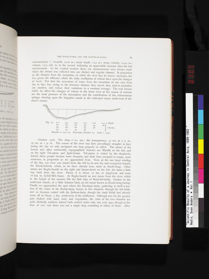
measurements — breadth, 22.86 m. ; mean depth, 1.473 m.; mean velocity, 0.5227 m.; volume, 17.60 cub. m. in the second, indicating an appreciable increase since the last measurement. As the vertical sections show, my measurements were always made where the stream was collected into one distinct and regular channel. In proportion as the distance from the mountains, in which the river has its source, increases, the less grows the influence which the daily oscillations of volume have upon the changes of level. Not that the accessions of water from the mountains do not vary from day to day; but, owing to the immense distance they travel, they tend to neutralise one another, and reduce their variations to a constant average. The real factors which do affect the changes of volume in the lower river at the season of autumn are the local pressure of the atmosphere and the contributions of the subterranean springs, drawing upon the irrigation canals in the cultivated tracts north-west of the river's course.
Fig. 72. 2.96 3.xz 2.04 I.48 0.58 0.14 = depth.
6o 6o 6o 55 40 28
6o 6o 6o 53 36 velocity.
63 52 51 51
Breadth = 22.86 m. Usun-jurt, October 22. Scale 1 : Soo.
October 23rd. The drop = 0.7 cm. ; the transparency, i 5 cm. at 7 a. m., 19 cm. at i p. m. The course of the river was here prevailingly straight; in fact, during the day we only navigated one loop properly so called. The names of the forests and other noteworthy topographical features are Mäsälik on the left, and on the right Tal-satma and Jigde-kotan. Tal-satma is visited by the shepherds; indeed, these people became more frequent, and their huts, occupied or empty, more numerous, in proportion as we approached Avat. Next, at the one large winding of the day, our river was joined from the left by its now dry and overgrown branch, the Kuruk-köbrük, which, as we have already seen, starts at Atschi-dung. Other names are Boghu-baschi on the right and Jaman-dasch on the left, the latter a little way back from the river. Hence it is about i 2 km. to Jangi-avat and some z 6 km. to Aj-köl-Möl-Anam. At Boghu-baschi an arm issues from the river, which in the height of the summer fills the little lake of Bisch-köl-täräk. Farther to the south-east stands, at a little distance back, an old masar known as Kosch-dung-dschaj. Finally we approached the spot where the Kaschgar-darja, gathering to itself a portion of the water of the Kodaj-darja, bursts, in two channels, through the left bank, and so becomes united with the Jarkent-darja, though the canal Bulak had already come off at Sarat, 3 km. north-west of the confluence. Although now for the greater part choked with sand, mud, and vegetation, the ends of the two channels are quite distinctly marked; indeed both carried water only one year ago, though at the time of our visit there was not a single drop remaining in either of them. After
|
Copyright (C) 2003-2019 National Institute of Informatics and The Toyo Bunko. All Rights Reserved.