国立情報学研究所 - ディジタル・シルクロード・プロジェクト
| |||||||||
|
| History of the expedition in Asia, 1927-1935 : vol.3 | |
| 中央アジア探検史 : vol.3 |
 |
| パーカー.C.陳が作成したコンチェ=ダリヤ・クム=ダリヤ分岐点付近の略図。北のダムが壊れたことについては本文で述べた。南のダムはPl.35参照。四つの掘られた水路は徳門堡の「T」字のすぐ下の開口部のように示した。(水流を古い水路に戻そうとする仕事は最少の労働者に与えられる所から始まったが、失敗する運命にあったことは計画から明らかだ。流れを下流のわきへそらす試みは、左へ曲がっている所の方が、より成功するであろう。F.B.)。Sketch-map of the place of bifurcation between the Konche-darya and the Qum-darya drawn by Parker C. Chen. The northern dam is the one whose destruction is mentioned in the text. The southern one is seen in Pl. 35. The four dug passages are here marked as one opening just below the letter ≫T≫ in Temenpu. (It is evident from the plan that the work of forcing the water back into the old channel was started at a spot that afforded the least labour, but that it was doomed to fail. An attempt to divert the river lower down, where it bends to the left, would have been more successful. F. B.) |
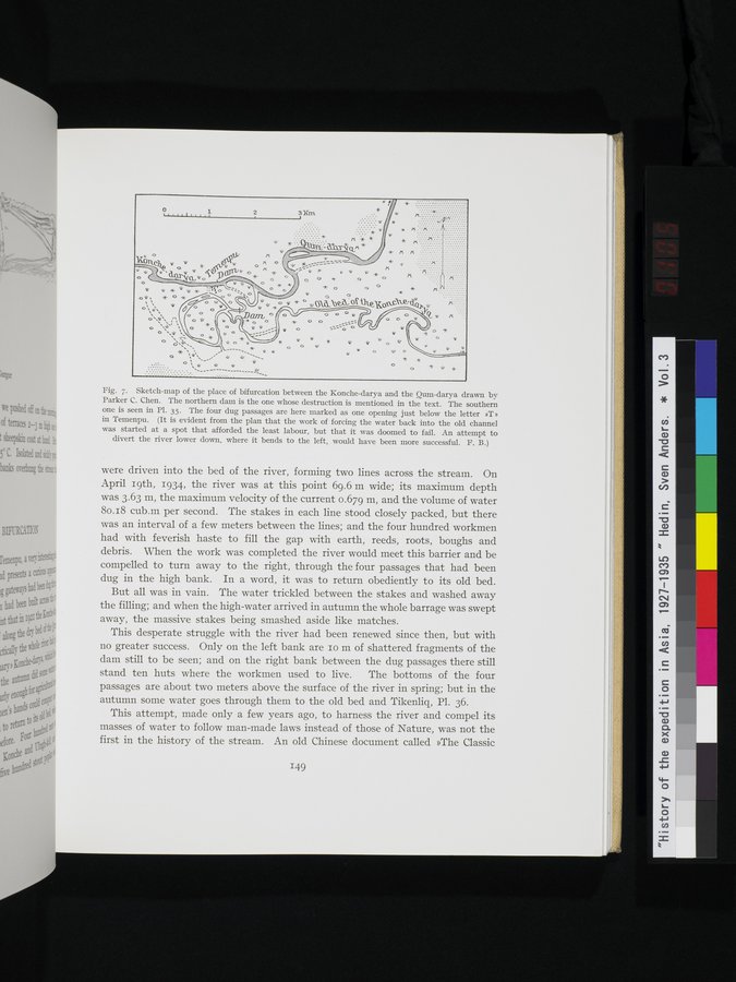
Fig. 7. Sketch-map of the place of bifurcation between the Konche-darya and the Qum-darya drawn by Parker C. Chen. The northern dam is the one whose destruction is mentioned in the text. The southern one is seen in Pl. 35. The four dug passages are here marked as one opening just below the letter »T» in Temenpu. (It is evident from the plan that the work of forcing the water back into the old channel was started at a spot that afforded the least labour, but that it was doomed to fail. An attempt to
divert the river lower down, where it bends to the left, would have been more successful. F. B.)
were driven into the bed of the river, forming two lines across the stream. On April 19th, 1934, the river was at this point 69.6 m wide; its maximum depth was 3.63 m, the maximum velocity of the current 0.679 m, and the volume of water 80.18 cub.m per second. The stakes in each line stood closely packed, but there was an interval of a few meters between the lines; and the four hundred workmen had with feverish haste to fill the gap with earth, reeds, roots, boughs and debris. When the work was completed the river would meet this barrier and be compelled to turn away to the right, through the four passages that had been dug in the high bank. In a word, it was to return obediently to its old bed.
But all was in vain. The water trickled between the stakes and washed away the filling; and when the high-water arrived in autumn the whole barrage was swept away, the massive stakes being smashed aside like matches.
This desperate struggle with the river had been renewed since then, but with no greater success. Only on the left bank are 10 m of shattered fragments of the dam still to be seen; and on the right bank between the dug passages there still stand ten huts where the workmen used to live. The bottoms of the four passages are about two meters above the surface of the river in spring; but in the autumn some water goes through them to the old bed and Tikenliq, Pl. 36.
This attempt, made only a few years ago, to harness the river and compel its masses of water to follow man-made laws instead of those of Nature, was not the first in the history of the stream. An old Chinese document called »The Classic
149
|
Copyright (C) 2003-2019
National Institute of Informatics(国立情報学研究所)
and
The Toyo Bunko(東洋文庫). All Rights Reserved.
本ウェブサイトに掲載するデジタル文化資源の無断転載は固くお断りいたします。