国立情報学研究所 - ディジタル・シルクロード・プロジェクト
| |||||||||
|
| Innermost Asia : vol.1 | |
| 極奥アジア : vol.1 |
 |
Position of watchtowers
T. xxII. d-f.
Clearing of
watch-post
T. xxu. d.
Sec. i] THE LIMES LINE NORTH-WEST OF TUN-HUANG 345
remains of the wall could be traced over the space, about ten miles in direct distance, which extends from the tower T. xxii. c, near the outflow of the Khara-nôr, to the vicinity of the station T. xxIII. b. The Khara-nôr, as seen in Map No. 38. A. 4, attains here its greatest width, and in March, 1914, was an open sheet of water, over two miles wide in most places and fringed by a marshy belt on the south. It must have offered adequate protection against attack almost throughout the year ; for it may be doubted whether the Khara-nôr, on account of the salinity of the water left in it after the spring and summer flood has passed, is ever covered with solid ice for very long.
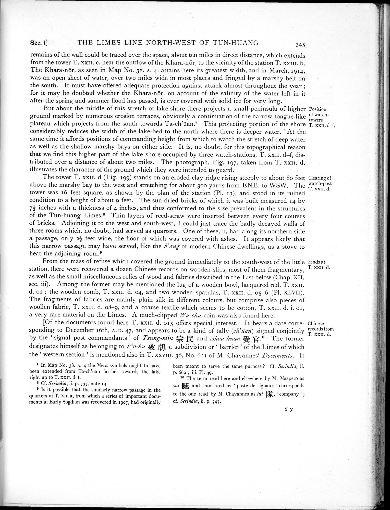
But about the middle of this stretch of lake shore there projects a small peninsula of higher ground marked by numerous erosion terraces, obviously a continuation of the narrow tongue-like plateau which projects from the south towards Ta-ch`üan.7 This projecting portion of the shore considerably reduces the width of the lake-bed to the north where there is deeper water. At the same time it affords positions of commanding height from which to watch the stretch of deep water as well as the shallow marshy bays on either side. It is, no doubt, for this topographical reason that we find this higher part of the lake shore occupied by three watch-stations, T. xxii. d—f, distributed over a distance of about two miles. The photograph, Fig. 197, taken from T. xxii. d, illustrates the character of the ground which they were intended to guard.
The tower T. xxii. d (Fig. 199) stands on an eroded clay ridge rising steeply to about 8o feet above the marshy bay to the west and stretching for about 30o yards from ENE. to WSW. The tower was 16 feet square, as shown by the plan of the station (Pl. 13), and stood in its ruined condition to a height of about 9 feet. The sun-dried bricks of which it was built measured 14 by 71 inches with a thickness of 4 inches, and thus conformed to the size prevalent in the structures of the Tun-huang Limes.8 Thin layers of reed-straw were inserted between every four courses of bricks. Adjoining it to the west and south-west, I could just trace the badly decayed walls of three rooms which, no doubt, had served as quarters. One of these, ii, had along its northern side a passage, only 2-- feet wide, the floor of which was covered with ashes. It appears likely that this narrow passage may have served, like the k`ang of modern Chinese dwellings, as a stove to heat the adjoining room.9
From the mass of refuse which covered the ground immediately to the south-west of the little station, there were recovered a dozen Chinese records on wooden slips, most of them fragmentary, as well as the small miscellaneous relics of wood and fabrics described in the List below (Chap. XII. sec. iii). Among the former may be mentioned the lug of a wooden bowl, lacquered red, T. xxii. d. 02 ; the wooden comb, T. xxII. d. 04, and two wooden spatulas, T. xxii. d. 05-6 (Pl. XLVII). The fragments of fabrics are mainly plain silk in different colours, but comprise also pieces of woollen fabric, T. xxii. d. 08-9, and a coarse textile which seems to be cotton, T. xxii. d. i. 01, a very rare material on the Limes. A much-clipped Wu-chu coin was also found here.
[Of the documents found here T. xxii. d. 015 offers special interest. It bears a date corresponding to December 16th, A. D. 47, and appears to be a kind of tally (eh`üan) signed conjointly
by the ` signal post commandants ' of Tsung-min ; and Shou-kuan '-.10 The former
designates himself as belonging to Po-lau j, a subdivision or ` barrier ' of the Limes of which
the ` western section ' is mentioned also in T. xxv1I1. 36, No. 621 of M. Chavannes' Documents. It
Finds at T. xxu. d.
Chinese records from T. xxu. d.
7 In Map No. 38. A. 4 the Mesa symbols ought to have been extended from Ta-ch`üan farther towards the lake right up to T. xxll. d-f.
8 Cf. Serindia, ii. p. 737, note 14.
9 Is it possible that the similarly narrow passage in the quarters of T. xi'. a, from which a series of important documents in Early Sogdian was recovered in 1907, had originally
been meant to serve the same purpose ? Cf. Serindia, ii. p. 669 ; iii. Pl. 39.
10 The term read here and elsewhere by M. Maspero as
sui and translated as ` poste de signaux ' corresponds
to the one read by M. Chavannes as lui I, ` company ' ; cf. Serindia, ii. p. 747.
Yy
|
Copyright (C) 2003-2019
National Institute of Informatics(国立情報学研究所)
and
The Toyo Bunko(東洋文庫). All Rights Reserved.
本ウェブサイトに掲載するデジタル文化資源の無断転載は固くお断りいたします。