国立情報学研究所 - ディジタル・シルクロード・プロジェクト
| |||||||||
|
| Serindia : vol.1 | |
| セリンディア : vol.1 |
 |
Old cultivation near Langar.
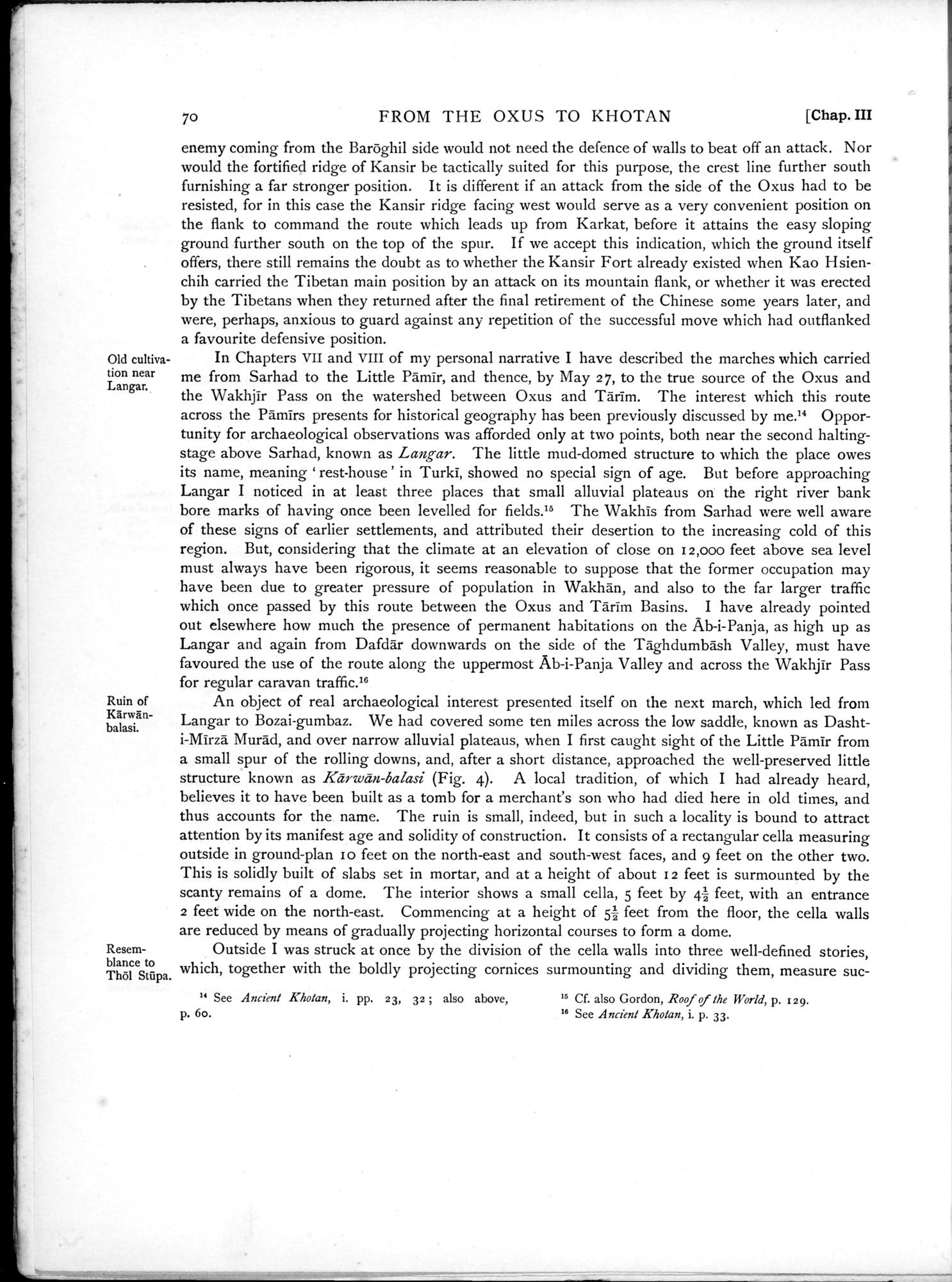
Ruin of Kârwanbalasi.
Resemblance to Th61 Stûpa.
70 FROM THE OXUS TO KHOTAN [Chap. III
enemy coming from the Baroghil side would not need the defence of walls to beat off an attack. Nor would the fortified ridge of Kansir be tactically suited for this purpose, the crest line further south furnishing a far stronger position. It is different if an attack from the side of the Oxus had to be resisted, for in this case the Kansir ridge facing west would serve as a very convenient position on the flank to command the route which leads up from Karkat, before it attains the easy sloping ground further south on the top of the spur. If we accept this indication, which the ground itself offers, there still remains the doubt as to whether the Kansir Fort already existed when Kao Hsienchih carried the Tibetan main position by an attack on its mountain flank, or whether it was erected by the Tibetans when they returned after the final retirement of the Chinese some years later, and were, perhaps, anxious to guard against any repetition of the successful move which had outflanked a favourite defensive position.
In Chapters vii and VIII of my personal narrative I have described the marches which carried me from Sarhad to the Little Pamir, and thence, by May 27, to the true source of the Oxus and the Wakhjir Pass on the watershed between Oxus and Tarim. The interest which this route across the Pamirs presents for historical geography has been previously discussed by me.14 Opportunity for archaeological observations was afforded only at two points, both near the second halting-stage above Sarhad, known as Langar. The little mud-domed structure to which the place owes its name, meaning ` rest-house ' in Turki, showed no special sign of age. But before approaching Langar I noticed in at least three places that small alluvial plateaus on the right river bank bore marks of having once been levelled for fields.15 The Wakhis from Sarhad were well aware of these signs of earlier settlements, and attributed their desertion to the increasing cold of this region. But, considering that the climate at an elevation of close on 12,000 feet above sea level must always have been rigorous, it seems reasonable to suppose that the former occupation may have been due to greater pressure of population in Wakhan, and also to the far larger traffic which once passed by this route between the Oxus and Tarim Basins. I have already pointed out elsewhere how much the presence of permanent habitations on the Ab-i-Panja, as high up as Langar and again from Dafdar downwards on the side of the Taghdumbash Valley, must have favoured the use of the route along the uppermost Ab-i-Panja Valley and across the Wakhjir Pass for regular caravan traffic."
An object of real archaeological interest presented itself on the next march, which led from Langar to Bozai-gumbaz. We had covered some ten miles across the low saddle, known as Dashti-Mirza Murad, and over narrow alluvial plateaus, when I first caught sight of the Little Pamir from a small spur of the rolling downs, and, after a short distance, approached the well-preserved little structure known as Keirwân-balasi (Fig. 4). A local tradition, of which I had already heard, believes it to have been built as a tomb for a merchant's son who had died here in old times, and thus accounts for the name. The ruin is small, indeed, but in such a locality is bound to attract attention by its manifest age and solidity of construction. It consists of a rectangular cella measuring outside in ground-plan r o feet on the north-east and south-west faces, and 9 feet on the other two. This is solidly built of slabs set in mortar, and at a height of about i 2 feet is surmounted by the scanty remains of a dome. The interior shows a small cella, 5 feet by 42 feet, with an entrance 2 feet wide on the north-east. Commencing at a height of 51- feet from the floor, the cella walls are reduced by means of gradually projecting horizontal courses to form a dome.
Outside I was struck at once by the division of the cella walls into three well-defined stories, which, together with the boldly projecting cornices surmounting and dividing them, measure suc-
" See Ancient Kholan, i. pp. 23, 32 ; also above, 'b Cf. also Gordon, Roof of the World, p. 129.
p. 6o. 16 See Ancient Kholan, i. p. 33.
|
Copyright (C) 2003-2019
National Institute of Informatics(国立情報学研究所)
and
The Toyo Bunko(東洋文庫). All Rights Reserved.
本ウェブサイトに掲載するデジタル文化資源の無断転載は固くお断りいたします。