国立情報学研究所 - ディジタル・シルクロード・プロジェクト
| |||||||||
|
| Innermost Asia : vol.4 | |
| 極奥アジア : vol.4 |
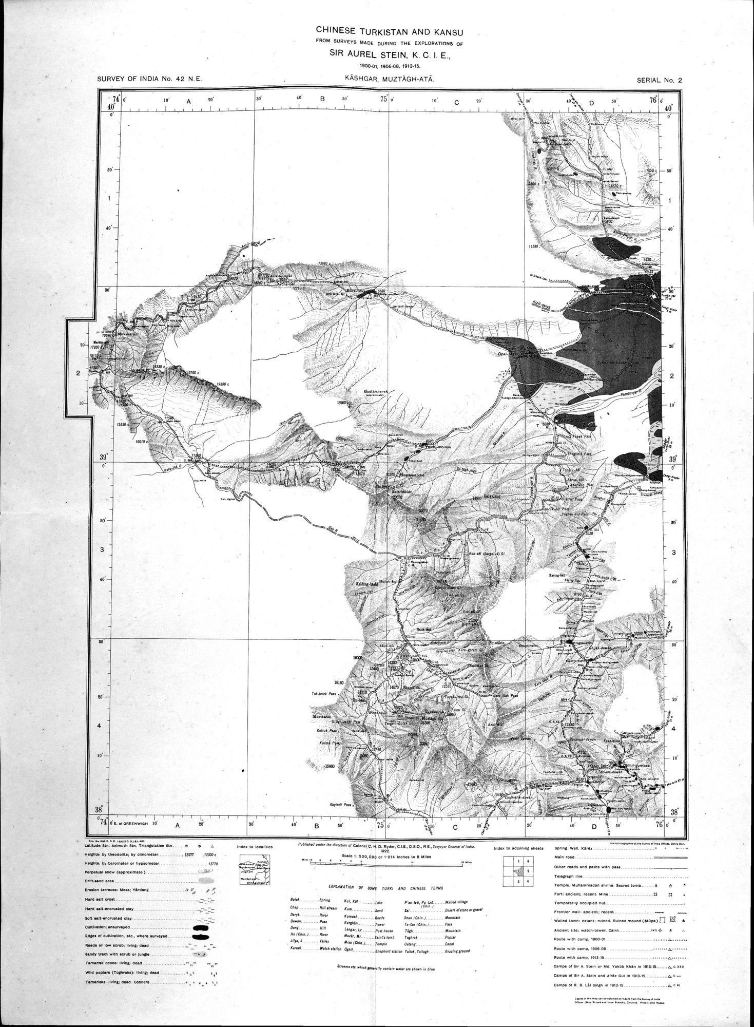 |
| オーレル・スタイン卿(インド勲章上級爵士)の3度にわたる探検(1900-01、1906-08、1913-15)で実施された調査にもとづく、中国領トルキスタンおよび甘粛の地域別地図 カシュガル、ムスター・アタ峰CHINESE TURKISTAN AND KANSU FROM SURVEYS MADE DURING THE EXPLORATIONS OF SIR AUREL STEIN, K.C.I.E., 1900-01, 1906-08, 1913-15. KĀSHGAR, MUZTĀGH-ATĀ |
| SURVEY OF INDIA No. 42 N. E. | CHINESE TURKISTAN AND KANSU FROM SURVEYS MADE DURING THE EXPLORATIONS OF SIR AUREL STEIN, K. C. I. E., 1900-01. 190000 1913-10 KASHGAR, MUZTAGH-ATA. | SERIAL No. 2 |
| 14. • ■••••••• • nato• Was. Un. Manta Stn. ,M•IntIt. Un. t • • NORM by ...DM Dy Ceamatas MS HOP. by Is* Or hytteœnete. MIM tatild0 amt. snow (appreMat.) Prataa,o w* —felb CreOen tamseM ML Sltdaaa 4 44 • ft nanl salt cnott sart.enent.M OA/ CortnatIon.onsusseyea Ega Cages or oultnation. Ns , Mere May. MI" or W. son. isong.øn .. _7-May Mtn Mtn ana O, panlie •••..2 Tarnanolt cones. Wing, ma yod 'swan (Toplooka), PAM OM • jo | IndOs IC | INMAN? +NW so Artetio. d Colo* O. H. IX Roar, WE, 080, RE.$.RIlIL fORL Sow h 100.08/ Or 1.014 moos to I MOM | pd. IM AMRlatad SNOM |
Slain n.d. Canoe we. end Ma seal pm* Mega. S. Tamp.. Munarnmadan $AMS. Ilaceed WM.. d â 14 10•1: ancient: taunt. Y. 13
Woe. Ms, aslant, M.O. Ruined mound (1.0.1/1 ig • Meant sae; saleaMses. Reste wile amp. 1100.0I Route tote camp. 9060e . a. AAA. vota csonts. MS-IS 0.• Camps M SW A. 'WA 0. be vudo NM,. M ..... Cam. or Or A. Stain and APIs OW M 190.1S SC- C.p. el R. • UI Men R IRIS-IS Se so | ||||||||
| "PU•An°N Of SOME IEIRA I AND CNIMISE TERMS | ||||||||||||
| /obi SO6M CA KW La. I'L5.10,rxre, 11,114.alme Cil• Ilia stream RN. . SANS SM .. DANN of owe, ErANE OmDA Rim ye.. ReLd. SW (4...) Rowels le.., TL.LLA feast., Ps. Dom MN E.Agm, LI Rot .....• 74. ...L.* _(aW) ... -Nob N. al, i,,,,,,,,A ',Von IsSe kV. A TAIMA Mat ( CAIN.) TANAN Own, Canal "."' -W.4. '6" 4. SNAANAAA 141.• 1,1a. rsdagt Ouzo, paged | ||||||||||||
| Moot meets II. NAN• *le tioss alur | ||||||||||||
*Pen .040 IAN. 6. •■•• ••••••■• Corm. ...Ow 1.10..
|
Copyright (C) 2003-2019
National Institute of Informatics(国立情報学研究所)
and
The Toyo Bunko(東洋文庫). All Rights Reserved.
本ウェブサイトに掲載するデジタル文化資源の無断転載は固くお断りいたします。