National Institute of Informatics - Digital Silk Road Project
| |||||||||
|
| Eine Routenaufnahme durch Ostpersien : vol.2 |
 |
t
Fg
»
»
»
»
»
»
»
»
»
»
»
20
S 70
2.4
19.91
20
2.8
S 80
5 S 40 0.3
25 S 80 3.5
20 S 80 2.8
20 S 110 3.8
7 S 270 3.2
5 S 33 0 2.7
4 S 15 0 1.0
6 S 50 0.5
10
S 120
10 S
10 S
5 S 70
7 S 16W
3
S 4W
5
5
S 20 0 1.7
S 200 1.7
4 S 15 0 1.0
5 S 400 3.2
5 600 2.6
5700 2.8
40.0 6.7
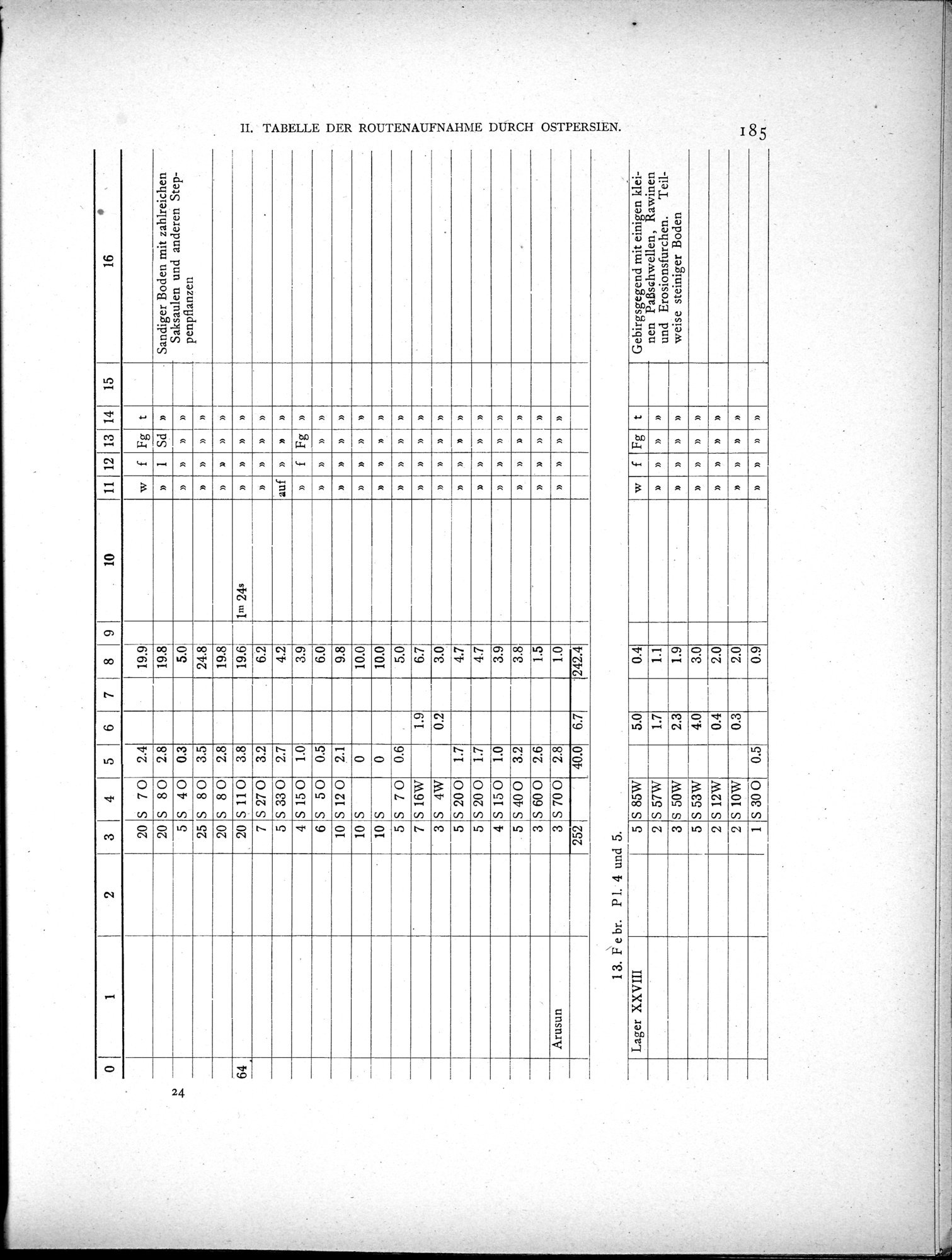
13. F e br. P 1. 4 und 5.
Sd
Arusun
» »
» »
Fg
»
»
»
»
»
»
» »
»
H. TABELLE DER ROUTENAUFNAHME DURCH OSTPERSIEN.
» »
f
1
19.8e
5.0
24.8
19.8
19.61 1n' 24s
6.2
4.2
3.9
6.0
9.8
10.0
10.0
5.0
6.7
3.0
4.7
4.7
3.9
3.8
1.5
1.0
242.4
»
auf
f
f
5.0
t
5
0.4
Fg
Lager XXVIII
»
2
1.7
1.1
1.9
»
»
2.3
3
3.0
»
4.0
» »
»
5
2
0.4
2.0
2
~ »
0.3
2.0
0.9
»
0.5
» » »
1
S 85W
S 57W
S 50W
S 53W
S 12W
S 10W
S 30 0
Gebirgsgegend mit einigen kleinen PaBschwellen, Rawinen und Erosionsfurchen. Teilweise steiniger Boden
1 2
3 4 5 6 7 8 9 . 10 11 12 13 14 15 16
•
Sandiger Boden mit zahlreichen Saksaulen und anderen Steppenpflanzen
»
2.1
0
0
0.6
1.9
0.2
3
3
252
|
Copyright (C) 2003-2019 National Institute of Informatics and The Toyo Bunko. All Rights Reserved.