National Institute of Informatics - Digital Silk Road Project
| |||||||||
|
| Eine Routenaufnahme durch Ostpersien : vol.2 |
 |
16
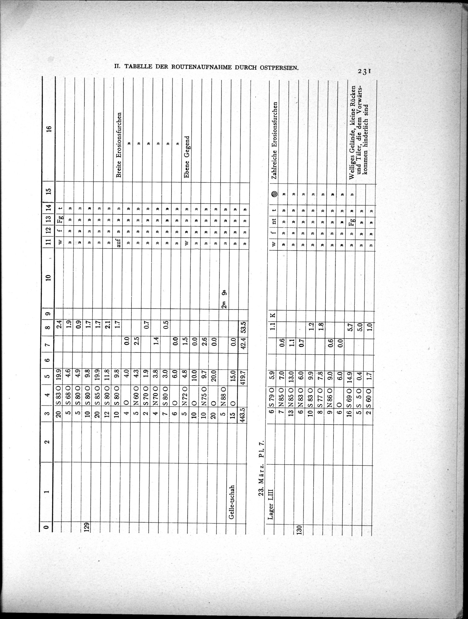
0 1 2 3 4 5 6 7 8 9 10 11 12 13 14 15
20 S 83 0 19.9 2.4 w f Fg t
4.6
S 68 0
1.9
5
»
»
»
4.9
S 80 0
5
0.9
D
D
»
D
9.8
S 80 0
10
1.7
129
D
n
»
19.9
20
S 85 0
1.7
»
»
»
11.8
12
S 80 0
2.1
»
D
»
1.4
Breite Erosionsfurchen
9.8
auf
10
S 80 0
1.7
»
»
»
4.0
0.0
4
0
»
n
n
»
D
4.3
2.5
5
N600
n
»
»
»
n
1.9
2
S 70 0
0.7
n
n
3.8
4
N700
1.4
n
n
n
»
»
3.0
7
0.5
S 80 0
n
n
n
n
6.0
6
0
0.0
n
n
»
»
»
5
10
10
4.8
Ebene Gegend
N72 O O
1.5
n
n n
n
w
10.0
0.0
n
»
D
9.7
2.6
N75 O
n
n
n
20
20.0
o
N88 0
0.0
n
n
n
5
2m 9s »
n
n
n
Gelle-tschah
15
15.0
0.0
O
n
n
n
»
443.5
419.7
42.4
53.5
n
n
n
n
23. März. P1. 7.
Lager LIII
6 S 79 0
7 N85 0 13 N85 O
6 N83 0 10 S 83 0
5.9 7.0 13.0 6.0
f nt
n n
1.1
K
Zahlreiche Erosionsfurchen
t
0.6
1.1
0.7
n
n
130
»
n
9.9
1.2
»
S 77 0
8
7.8
1.8
»
N86 O O
9
9.0
0.6
»
n
6
6.0
0.0
S 69 0
16
14.9
5.7
Fg
Welliges Gelände, kleine Rücken und Täler, die dem Vorwärtskommen hinderlich sind
n
S 50
5
0.4
5.0
»
S 60 0
2
1.7
1.0
»
D
|
Copyright (C) 2003-2019 National Institute of Informatics and The Toyo Bunko. All Rights Reserved.