National Institute of Informatics - Digital Silk Road Project
| |||||||||
|
| In Tibet and Chinese Turkestan : vol.1 |
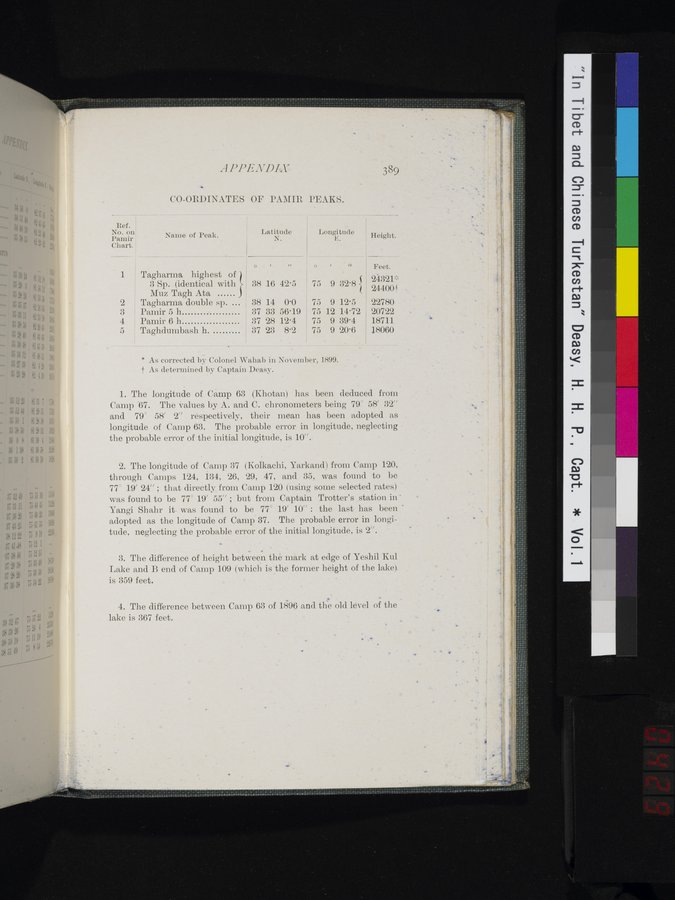 |
APPENDIX
3 S9
CO-ORDINATES OF PAMIR PEAKS.
| Ref. No. on Name of Peak. Pamir Chart. |
| Latitude N. | Longitude E. O , ,/ • 75 9 32.8 { 75 9 12.5 75 12 14.72 75 9 39.4 75 9 20.6 | Height. | ||
| 1 2 3 4 5 | Tagharma highest of 3 Sp. (identical with Muz Tagh Ata Pamir 5 h Pamir 6 h Taghdumbash h. | O 38 38 37 37 37 | I 16 14 33 28 23 | „ 42.5 0.0 56.19 12.4 8.2 | Feet. 24321* 24400-1- 22780 20722 18711 18060 | |
* As corrected by Colonel Wahab in November, 1899. t As determined by Captain Deasy.
The longitude of Camp 63 (Khotan) has been deduced from Camp "67. The values by A. and C. chronometers being 79° 58' 32" and 79° 58' 2" respectively, their mean has been adopted as longitude of Camp 63. The probable error in longitude, neglecting - the probable error of the initial longitude, is 10".
The longitude of Camp 37 (Kolkachi, Yarkand) from Camp 120, through Camps 124, 134, 26, 29, 47, and 35, was found to be 77° 19' 24" ; that directly from Camp 120 (using some selected rates) was found to be 77° 19' 55" ; but from Captain Trotter's station in • Yangi Shahr it- was found to be 77° 19' 10" : the last has been • adopted as the longitude of Camp 37. The probable error in longitude, neglecting the probable error of the initial longitude, is 2".
The difference of height between the mark at edge of Yeshil Kul Lake and B end of Camp 109 (which is the former height of the lake). is 359 feet.
The difference between Camp 63 of 1896 and the old level of the lake is 367 feet.
...
|
Copyright (C) 2003-2019 National Institute of Informatics and The Toyo Bunko. All Rights Reserved.