国立情報学研究所 - ディジタル・シルクロード・プロジェクト
| |||||||||
|
| Serindia : vol.1 | |
| セリンディア : vol.1 |
 |
Chinese oc-
cupation of
Little
Identification of Kao Hsien-chih's route.
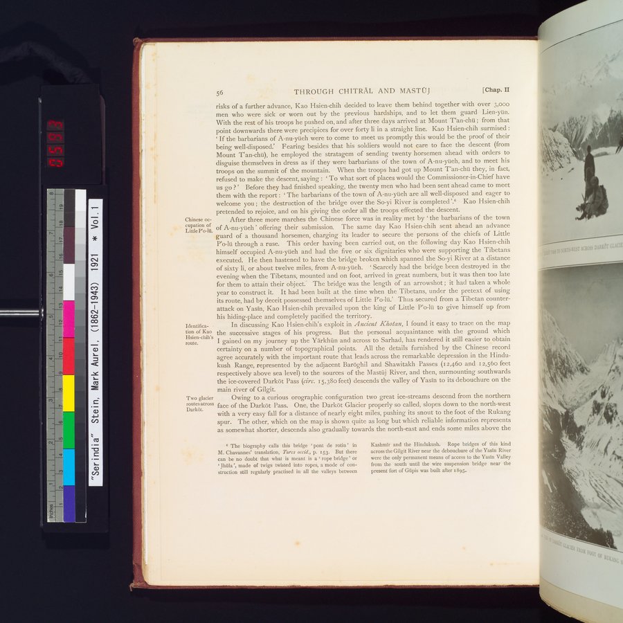
Two glacier routes across Darkôt.
56 THROUGH CHITRAL AND MASTOJ [Chap. II
risks of a further advance, Kao Hsien-chih decided to leave them behind together with over 3,000 men who were sick or worn out by the previous hardships, and to let them guard Lien-yün. With the rest of his troops he pushed on, and after three days arrived at Mount Tan-chü ; from that point downwards there were precipices for over forty li in a straight line. Kao Hsien-chih surmised : ` If the barbarians of A-nu-yüeh were to come to meet us promptly this would be the proof of their being well-disposed.' Fearing besides that his soldiers would not care to face the descent (from Mount Tan-chü), he employed the stratagem of sending twenty horsemen ahead with orders to disguise themselves in dress as if they were barbarians of the town of A-nu-yüeh, and to meet his troops on the summit of the mountain. When the troops had got up Mount Tan-chü they, in fact, refused to make the descent, saying : ` To what sort of places would the Commissioner-in-Chief have us go ? ' Before they had finished speaking, the twenty men who had been sent ahead came to meet them with the report : ` The barbarians of the town of A-nu-yüeh are all well-disposed and eager to welcome you ; the destruction of the bridge over the So-yi River is completed '.6 Kao Hsien-chih pretended to rejoice, and on his giving the order all the troops effected the descent.
After three more marches the Chinese force was in reality met by ` the barbarians of the town of A-nu-yüeh' offering their submission. The same day Kao Hsien-chih sent ahead an advance guard of a thousand horsemen, charging its leader to secure the persons of the chiefs of Little P`o-lü through a ruse. This order having been carried out, on the following day Kao Hsien-chih himself occupied A-nu-yüeh and had the five or six dignitaries who were supporting the Tibetans executed. He then hastened to have the bridge broken which spanned the So-yi River at a distance of sixty li, or about twelve miles, from A-nu-yüeh. ` Scarcely had the bridge been destroyed in the evening when the Tibetans, mounted and on foot, arrived in great numbers, but it was then too late for them to attain their object.' The bridge was the length of an arrowshot ; it had taken a whole year to construct it. It had been built at the time when the Tibetans, under the pretext of using its route, had by deceit possessed themselves of Little P`o-lü.' Thus secured from a Tibetan counterattack on Yasin, Kao Hsien-chih prevailed upon the king of Little P`o-lii to give himself up from his hiding-place and completely pacified the territory.
In discussing Kao Hsien-chih's exploit in Ancient Kholan, I found it easy to trace on the map the successive stages of his progress. But the personal acquaintance with the ground which I gained on my journey up the Yârkhûn and across to Sarhad, has rendered it still easier to obtain certainty on a number of topographical points. All the details furnished by the Chinese record agree accurately with the important route that leads across the remarkable depression in the Hindukush Range, represented by the adjacent Baroghil and Shawitakh Passes (i 2,460 and 12,560 feet respectively above sea level) to the sources of the Mastûj River, and then, surmounting southwards the ice-covered Darkôt Pass (circ. 15,38o feet) descends the valley of Yasin to its debouchure on the main river of Gilgit.
Owing to a curious orographic configuration two great ice-streams descend from the northern face of the Darkôt Pass. One, the Darkôt Glacier properly so called, slopes down to the north-west with a very easy fall for a distance of nearly eight miles, pushing its snout to the foot of the Rukang spur. The other, which on the map is shown quite as long but which reliable information represents as somewhat shorter, descends also gradually towards the north-east and ends some miles above the
° The biography calls this bridge pont de rotin ' in M. Chavannes' translation, Turcs occid., p. 153. But there can be no doubt that what is meant is a ` rope bridge ' or Jhula', made of twigs twisted into ropes, a mode of construction still regularly practised in all the valleys between
Kashmir and the Hindukush. Rope bridges of this kind across the Gilgit River near the debouchure of the Yasin River were the only permanent means of access to the Yasin Valley from the south until the wire suspension bridge near the present fort of Gupis was built after 1895.
|
Copyright (C) 2003-2019
National Institute of Informatics(国立情報学研究所)
and
The Toyo Bunko(東洋文庫). All Rights Reserved.
本ウェブサイトに掲載するデジタル文化資源の無断転載は固くお断りいたします。